
|
|
Mountain/Rock |
|---|---|
|
|
55.49770°N / 3.3533°W |
|
|
Scottish Borders |
|
|
Hiking |
|
|
Spring, Summer, Fall, Winter |
|
|
2756 ft / 840 m |
|
|
Broad Law is a Scottish Corbett summit at 840metres
| “Broad Law, a large, open, bleak and barren landscape. This is a peaceful summit, rarely touched giving a feeling or sense of total loneliness. The summit has a haunting silence. This allows you to sit and take your thoughts to another level. With these thoughts in your mind, relax, sit calm, breathe deep and take in the wonderful views it has here to offer you.” The feelings I had whilst on this summit (David Neale) – Broad Law Trek (5th May 2007) |
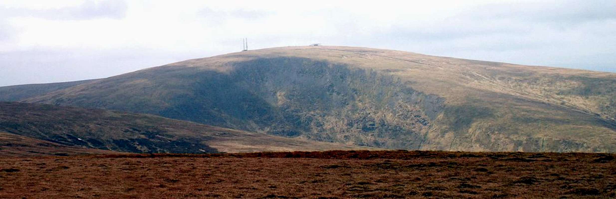
 Broad Laws northern ridge as seen from the A701 near Hearthstane
Broad Law is one of the highest mountains or in real terms large hills within the southern counties of Scotland. It dominates the landscape in the shape of a giant whale back and reaches a height of 840 metres at its Ordnance Survey trig point.
Broad Law is the highest summit in the Southern Upland region known as the Manor Hills. It has two other big neighbors as part of its large mass. These being the tops of Cramalt Craig at 831 metres and Dollar Law at 817 metres, both of these tops are to the east. The next nearest mass of summits over 800 metres are those of the Moffat Hills across the valleys of Talla and Megget to the west.
The summit of Broad Law or shall I say the mass is a pleasant set of hills to climb. Its summit consists of bleak and barren open grassland and is crowned with various telecoms related structures. Its steep western banks overlook the valleys of the Talla and Megget Reservoirs and are dappled with many different coloured heathers along with thick growths of bracken in there lower reaches. The long northern ridges that drop to the great Tweed valley are planted with commercial forestry consisting of Spruce and Fir trees. This forestry area has some brilliant access tracks running through it which are great for mountain biking. Broad Law itself has a track to its very summit so engineers can gain vehicle access to the telecoms related structures by 4x4.
On the eastern face of the summit overlooking the valley of Polmood Burn there is an impressive screed of rocks and debris that scar the valleys upper reaches. This is known as Polmood Craig. This screed of rocks was created like many of the valleys in this area by glacial action back in the last ice age.
The hill has the status of a Scottish Corbett and a UK Marylin:-
A Corbett is the collective name given to the mountains in Scotland which are between 2,500 feet and 3,000 feet high, and which have a re-ascent of 500 feet on all sides.
A UK Marylin is a mountain or hill in the British Isles (including Ireland) with a relative height of at least 150 metres (492 ft), regardless of absolute height or other merit.
 From Cappercleuch
 The summit trig
 From Hearthstane
Broad Law is famous for its height above sea level and there is only one other summit in the south of Scotland that is higher. This is the summit of The Merrick in the county of Dumfries and Galloway reaching a height of 843 metres making a difference of just 3 metres. Not Much…! The main Southern Upland summits and tops that are over 800 metres are those of Corserine in the Galloway Forest, Hart Fell and White Coomb in the Moffat Hills and The Cheviot in the Cheviot Hills and just across the border in England.
| Summit - Name | Height m | County:- | Grid Ref and Streetmap Links:- | Corbett:- | Marylin |
| 1 - THE MERRICK | 843 m | Dumfries and Galloway | NX427855 (Streetmap Link) | Yes | Yes |
| 2 - BROAD LAW | 840 m | Scottish Border | NT146235 (Streetmap Link) | Yes | Yes |
| 3 - WHITE COOMB | 821 m | Dumfries and Galloway | NT163150 (Streetmap Link) | Yes | Yes |
| 4 - THE CHEVIOT | 815 m | Northumberland | NT909205 (Streetmap Link) | No | Yes |
| 5 - CORSERINE | 814 m | Dumfries and Galloway | NX497870 (Streetmap Link) | Yes | Yes |
| 6 - HART FELL | 808 m | Dumfries and Galloway | NT113135 (Streetmap Link) | Yes | Yes |
There are many different routes to the summit of Broad Law. I will when I can add a detailed route page as a child to this page.
 From Garalet Hill
 From Cramalt Craig
 From White Coomb
  |
Broad Law is certainly a favourite of mine. I have been to its summit many times in total now. I can remember going up three times on foot and at least twice by vehicle in other words cheating. The times I accessed this by car where back in my days a telecoms surveyor doing detailed site surveys for the UK mobile phone network company Orange or OPCS who has antennas on the police radio tower.
I advise you seriously not to drive up here. Partly because it is only suitable for certain 4x4 vehicles in that it is very rough with deep ruts that you could lose your wheels in and bottom the car out. Not good...! The other reason is that the local landlord here is not the nicest of people. I have had problems in the past when driving to the towers. I have also met other hill walkers who have told me about there problems. There should be no issues about accessing this summit from any direction as the Scottish free to roam rule applies round here. I think there attitude towards walkers is to try and scare them away.
The track that leads to the summit does though pass through there farm but as an escape route off the summit in the worst of weather or an emergency there it is a clear route down with the houses at the farm if an alarm needs to be raised.
 Panorama WEST - NORTH - EAST
 Panorama EAST - SOUTH - WEST
The above panorama images are from the web site called Panoramas. This is a web site dedicated to graphical detailed panoramas from various summits all over the world. More information via this link Panoramas
What amazed me was whilst on a trek up to the summit of Lochnagar back in 2007 there is a viewing plate on Lochnagar that gives details of all the main summits which are visible from there. I could not believe this when I saw Broad Law was marked on there and even The Cheviot can be seen. That is a long way…!
 The Air Traffic Control Beacon looking more like a flying saucer
The telecoms related structures that crown this summit are a 40 metre radio tower, property of the Border and Lothian Police Authority, a smaller tower supporting a directional VHF antenna for the National Air Traffic Services. Then there is the bizarre flying saucer looking VOR-DME Air Traffic Control Beacon pictured above. There is also a large substation transformer that stands out in the open near to the summit trig point which supplies the electricity to all this bizarre kit. These telecoms related structures are some of the highest above sea level in Scotland beaten by the radio towers that crown and scar the rather sad Munro summit of The Cairnwell in the Glen Shee region of the Grampian Mountains.
 Both towers
 Old tower
 New tower
 VHF Antenna
Getting There:-
 Section from Ordnance Survey Landranger Sheet 72. Upper Clyde Valley - Biggar & Lanark
Wether heading south from Glasgow or north from Carlisle come off at Junction-15 and head into the cosy town of Moffat this has many cafe's and is a good snack stop when heading on your way. From Moffat take the A708 road signposted for Selkirk. This is a fantastic road up through Moffat Dale and it takes you through some stunning scenery flanked by high mountains and deep gorged corries on either side such as the summits of Saddle Yoke and the gorge of Black Hope Scar. Also on this route you pass one of Scotlands stunning waterfalls called the Grey Mare's Tail. When taking this road you come to a set of large lakes called Loch of Lowes and St Mary's Loch. When following round the north side of St Mary's Loch there is a small unclassified road to the left with an AA-Phone box beside it. Take this road towards Megget where you pass a gigantic man made lake / reservoir. Once past this lake the road slowly climbs and when you reach a cattle grid there is a small standing stone on the left called Megget Stone. Park here for the interesting route...!
For the not so interesting route follow the road as given above from the Megget stone and head on past another large lake called Talla. From Talla you come to a village called Tweedsmuir. Cross the River Tweed and when you reach the main A701 road take a right turn towards Peebles and Edinburgh. Follow the A701 for a short distance until you reach a farm and some houses called Heartstane. If you reach the Crook Inn Hotel you have gone too far. Park on the A701 not in the farm area and there is a strait forward access track right to the top of the Broad Law summit. This access track states 4x4 Vehicles only and is the access track for the Air Traffic Beacon and Police radio towers that crown the summit. Another route to this same parking place is via the A701 road all the way from the town of Moffat up and over the Devils Beef Tub and on through Tweedsdale to the spot.
Ordnance Survey Maps for Broad Law:-
1:50 000 Landranger Series
Sheet 72 Upper Clyde Valley – Biggar and Lanark
The Broad Law mass is in the very south-east corner of the map
1:25 000 Explorer Series
Sheet 330 Moffat and St Mary’s Loch – Megget Reservoir
The Broad Law mass is in the very north reaches of the map
Sheet 336 Biggar and Broughton – Culter Fell and Dollar Law
The Broad Law mass is in the very south-east corner of the map
1:250 000 Travel Map Series
Sheet 3 Southern Scotland and Northumberland
The Broad Law mass is in the centre of the bottom half of the map
More information from this link:-
Ordnance Survey
Streetmap link to – Megget Stone
Streetmap link to - Hearthstane
View Larger Map Of Area
Local geology:-
The geology of this area has many similarities to the region of the Moffat Hills. Follow the link in the section below called, Associated links for Moffat Hills link giving more information about this area. Below is a geological map of the Southern Uplands. A geological map representing the South Scotland area of Dumfries and Galloway and the Scottish Border
The Manor Hills like the neighbouring Moffat Hills have a rich and varied landscape. This is the result of aeons of geological activity combined with the relatively recent impact of man. Continents have collided, volcanoes have erupted, ice ages have come and gone and mighty rivers like the River Tweed have eroded the landscape. On a miniature scale, and in the last few moments of this story, farmers and forester’s have begun to scratch away at the surface of the land.
In the Southern Uplands of Scotland, Devonian and Carboniferous rocks are found mostly in the south and east. A typical scene in Devonian times is thought to be that of powerful, fast flowing rivers bringing sediment into lakes. By Carboniferous times Scotland was near the equator and our landscape was one of rainforest and tropical seas. Thick red sandstones show that by Permian times the area had become a desert.
The last part of the ice age was relatively recent, lasting from about 70,000 to 12,000 years ago. At one stage the whole of Scotland was under a great sheet of ice. Latterly the main ice accumulations in south Scotland were north of Glentrool, the Moffat Hills and nearby Tweedsmuir. Examples of glacially eroded valleys can be seen at Annan Dale, Black Hope, Carrifran Glen and the Valley of Moffat Dale, especially at The Grey Mare’s Tail and Tail Burn. Glacial valleys that surround Broad Law are those of the Talla and Megget Reservoirs and the valley of Polmood Burn that runs off north then cuts deep into the hills to join with the River Tweed at Tweedsdale.
Access and red tape:-
 Purple heathers growing on Broad Laws lower reaches.
There is no red tape out on the hills of Scotland.
The only thing I will say is respect the lower reaches of the valleys around the local farms and peoples gardens.
Camping and accomadation:-
The area surrounding these Manor Hills has many market towns that offer the services of hotels and bed and breakfasts etc:-These are just some links for the nearest market town of Moffat:-
Moffat Bed and Breakfast GOOGLE Search:-
BedandBreakfast-Directory.co.uk ( Moffat )
Moffat Camping GOOGLE Search:-
ukcampsite.co.uk ( Moffat )
Camping is also available in the wilds of the hills but look after the countryside whilst out there.
More about wild camping by searching on this site:-
Other towns within easy reach of Broad Law and the Manor Hills are as follows:-
Dumfries
Biggar
Galashiels
Hawick
Lockerbie
Peebles
Selkirk
Add these towns into a search engine such as Google also include bed and breakfast or camping in the search and the list should be endless...!
Mountain conditions and weather:-
Mountain Conditions:-The conditions on these mountains like any other can change very quick.
The main reason these summits can be nasty in the wrong weather is that all the interconnecting hills and ridges are of a large round undulating character and in the low cloud line or thick fog one can easily look like another. This if you do get lost and take the wrong route off can take you down into some of the really deep and isolated valleys that are a long way from any roads or population.
Although with plenty of forward planning along with the skills of a compass, map reading and a GPS you should, and I hope. Not have any problems...!
Weather Information:-
Below are a number of web links to sites that cover weather forecasts. I cannot say if there forecasts are all the same but its your choice what web site you decide choose. Even better take a look at all of them then compare there forecasts...!
This site covers weather for all mountain areas and has Broad Law as one of its primary areas...!
Winternet-Scotland
Accuweather Link:-
Accuweather Forecast
BBC 5-Day weather forecast:-
BBC 5-Day forecast for Moffat
Although Moffat is a distance away from the site most of this areas weather comes in from the west and north west via the Irish Sea and Moffat is to the west of Broad Law so the weather that hits Moffat is bound to hit Broad Law.
 In cold heavy snow
 Clear skys and sun
Useful and associated web links:-
 Standing under the VOR-DME Air Traffic Beacon
Links to Associated SP Pages:-
These are links to all the hills, mountains, ranges and albums that have been mentioned in this page and that have an associated SP page of there own.
Corbetts:-
Lochnagar:-
Marilyns of the British Isles:-
Merrick:-
Moffat Hills:-
Munros:-
Radio masts and towers Album:-
Saddle Yoke:-
Scotland:-
Summits from Summits album:-
The Cairnwell:-
White Coomb:-
Useful Links:-
Local Councils:-
Dumfries and Galloway Council
Scottish Borders Council
Websites:-
Gazetteer for Scotland
A web site with more about Moffat
Moffat Mountain Rescue Team
National Trust For Scotland
National Trust Scotland