
|
|
Mountain/Rock |
|---|---|
|
|
38.87360°N / 112.2526°W |
|
|
Millard |
|
|
10222 ft / 3116 m |
|
|
Overview
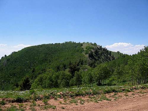
Mine Camp Peak
Tucked away in the Pahvant Mountains of central Utah, but visible from I-15 if you know where to look, is relatively unknown Mine Camp Peak, notable mainly for being the highest peak in Millard County and hence sought after by county highpointers. It also ranks #38 on the Utah prominence peak list thanks to having over 3000 feet of prominence. This part of the Pahvant mountain range also is part of Fishlake National Forest.
This is an often visited peak and a lot of great trip reports, some with GPS tracks can be found at peakbagger.com's excellent site. As of August 2015, peakbaggers lists over 64 ascents of this mountain. LINK.
Getting There & the Hike
From Salt Lake City, there are two ways to access Mine Camp Peak.I-15 Via Fillmore. Thanks to Dale Milsap for these directions provided in his COHP.org trip report

Topo of area
From Fillmore:
Take exit 167 off I-15 in Fillmore and travel south on Main Street for 1.7 miles. Turn left on 200 South Canyon Road and travel 0.8 mile east.
Turn right on 700 East Sand Rock Ridge and travel 0.4 mile south until pavement ends. Continue south and then east on a well-maintained gravel road 1.5 miles to a cattle guard and a sign indicating entry into the National Forest.
Continue up the gravel road an additional 2.5 miles. Here there is a parking area and minor roads to the left and a sign warning you that the road ahead is for jeep travel only. If you have 4WD and high clearance, take the main jeep road to the right (straight)and follow it 5 miles up the mountain to the cattle guard at the saddle and find a spot nearby to park and do the hike as presented below. It is rough and steep in places but is a good route. If you don't have high clearance and a 4WD vehicle, the Richfield route may work best if you at least have a high clearance vehicle.
Note: We saw several vehicles & ATV's go down the road from the saddle and it looked satisfactory. If I'm in the area again, I'll try the road up from
Fillmore, just to see how it goes. This area is hugely popular with ATV's and we saw tons of them so be aware of their presence. The Piute ATV trail is very popular in this area.
From Richfield:

I-70 Via Richfield (the way I went in)
How to get there: From Main Street in Richfield, turn west onto 300 North. Drive a short ways to the I-70 underpass. Zero the odometer (but as noted below, remember that your mileage may vary from mine).
0.0: I-70 underpass. Road turns to gravel.
0.3: Water Tank. Road continues to left, turns to hard pack.
1.2: FS Gate. Road can get rocky and steep
4.4: Junction, stay straight.
7.6: Junction, turn right onto Paiute ATV Trail.
11.0: Road gets rough. 4WD is nice to have.
13.7: Junction, turn right toward White Pine (Peak). Mine Camp Peak is visible as well.
15.3: Junction/Fork, turn left onto access road.
17.5: After a cattle grate, the road starts down west side of range. Park before the road drops. A space to the east of the road makes a good place.
Note: See rmjwinters summit log comment as he found the above mileage off by a tenth or two in places. Odometers may vary just a bit due to differences in tire sizes so be aware that the above mileage might vary for your vehicle. However, you shouldn't have a problem as he certifies.

The Hike (choices, always choices)
The EASY:
From the cattle grate, assuming you've driven to this point, Mine Camp is just across a small saddle. From the cattle grate, drop 200 feet or so, then gain 400 feet up the other side amid aspen and mint brush to the highpoint. A cairn and register was found and the view of the Fillmore valley was excellent. A note concerning the road from Richfield, as mentioned elsewhere, high clearance recommended as this is not a road for a passenger car and the road is part of the popular Paiute ATV trail (see map). A 2WD vehicle would make it but only in good weather. Avoid this road if it is raining and be wary of snow blocking the road if you go before July. Best to check at the local ranger station for more info. The road from Fillmore is much more challenging although shorter in length.
The HARD:
For those who want to truly make a solid hike out of this mountain, this hike is described in the High in Utah book as beginning from Fillmore and in the book, this hike is listed as 12 miles round trip, difficult, and has an elevation gain of 3,782 feet. The trailhead is listed as approached from Fillmore by heading south on 200 south (which will become Chalk Creek Road). Travel on this road for 9.5 miles and head to just beyond a picnic area. The Trailhead is listed as the Bear Canyon/Pine creek trail and the description of the hike is listed in the book (for more on the book, see links below) In a trip report by cohp'er Scott Casterlin, he describes his experience with this hike in this TRIP REPORT.
In the other Utah county highpoint book, Hiking Utah's Summits, the same hike is mentioned from the picnic area but I'll add just a bit more information. Neither book lists doing the hike from the cattle grate. Both mention the picnic area (the Pistol Rock Picnic area). Its mentioned that the TH is 0.2 miles beyond the picnic area and that a spur going right is what you are after when the main road goes to the left. This spur is the Bear Canyon/Pine Creek trailhead. Rather than divulge the authors hike information, I will refer you once again to the book, and again I have a link to the book down below.
Red Tape and weather
Fishlake National ForestRichfield Ranger Station
115 E. 900 North,
Richfield 84701,
435-896-9233
See their map of the area HERE.
WEATHER
 Camping
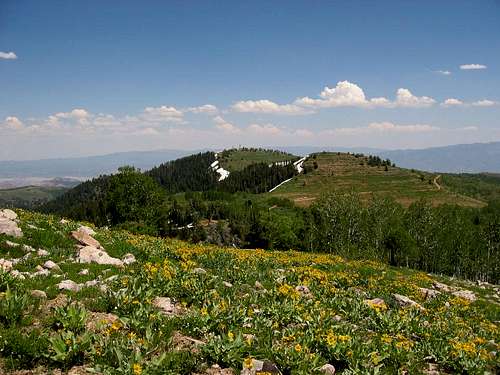
Motels in Richfield and Fillmore of course, and there are many places near Mine Camp Peak where primitive camping would be possible.
Fillmore KOA for those who want to rough it.
Millard County
Since the highpoint of this county has been well discussed, here are a fewtidbits about the county itself.
It was found that in 2000 (census) the population was 12,405. It was named for Millard Fillmore, thirteenth President of the United States of America.
They had named the main settlement Fillmore already so it was necessary to use President Fillmore's first name in naming the county. Who the heck was President Fillmore anyway. It looks like I'll have to go back to the history book and find out more about this relatively unknown president. Notice that the county seat is Fillmore and the largest city is Delta. Now Delta is out west in the Utah desert and one element of Millard County's economy is the digging of fossils. Trilobite fossils are relatively common in the region west of Delta (part of the Wheeler Shale) and at least one company, located near Antelope Springs, allows visitors to dig their own fossils for a fee.
15% of Millard county's economy is from farming.
External Links
BOOKSTwo books on Utah's county highpoints are available and both approach Mine Camp Peak via a hike from the Fillmore (I-15) side to the west.
High in Utah by Miller and Weibel
Hiking Utah's Summits by Paula Huff and Tom Wharton
Of the two books, High in Utah is the better of the two but the Hiking Utah's Summit book has a good background about the area.
A third book with useful information is Utah Byways by Tony Huegel (see pg 86)
Utah Byways
The County Highpoint website also has some very helpful trip reports
HISTORY OF RICHFIELD UTAH
MORE RICHFIELD HISTORY
EVEN MORE RICHFIELD HISTORY
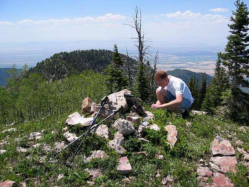
Summit cairn of Mine Camp Peak