
|
|
Mountain/Rock |
|---|---|
|
|
39.63658°N / 105.22259°W |
|
|
Jefferson County |
|
|
Hiking, Bouldering |
|
|
Spring, Summer, Fall, Winter |
|
|
7851 ft / 2393 m |
|
|
Overview
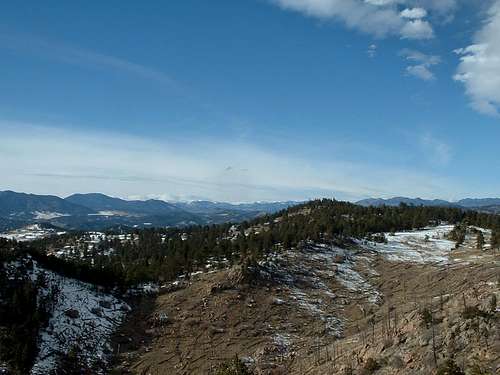 Beautiful Mt Falcon Views
Mount Falcon is located along the front range and is only a few minutes away from Morrison. This beautiful peak offers views of the city, Mount Evans, and even all the way to Pikes Peak. Mount Falcon is a great place to vist when you need to kill lazy weekends and to wind down after a long day of stress. Mount Falcon is a carefree mountain that offers many hidden suprises.
Who would have thought that you could eat lunch at a shelter overlooking beautiful valleys and the high country, then visit the historical ruins of John Brisben Walker's home. John Brisben Walker owned 4,000 acres of land in the area back in the early 1900's. Unfortunatly in 1918 his house burned down, and only the stone pillars and fireplaces remain. These remains will transport you to a different time when you visit.
Mount Falcon isn't as simple as it sounds, it includes 9 different trails that each lead to different areas. These 9 trails cover over 11.1 miles of amazing views. Mount Falcon also includes 2,248 acres of forest and one of Mount Falcon's trails (Devil's Elbow) actually enters the Denver Mtn. Park, but loops back in.
Mount Falcon unfortunatly bears a terrible scar, in the late 80's some of Mt. Falcons western slopes were scorched by a forest fire. This destruction can be viewed from the Parmalee and Castle Trails. It is amazing to see how much the area has recovered sinced the trajedy. Mount Falcon also includes a few bouldering opportunities for anyone who is willing to look hard enough.
When it comes down to it, Mount Falcon is for anyone looking to have a great time with great views!
Getting There
 Road To Western Trailhead
To reach the western trailhead, turn North off of Highway 285 onto Palrmalee Gulch Road, this is also known as the Indian Hills turnoff, it is near Tinytown. Follow Parmalee Gulch Road for 2.5 miles to Picutis Road that takes you east. On Picutis Road just follow the signs that will lead you up the mountain to the West Parking Area.
For Eastern Access to Mount Falcon take Colorado Highway 8 south of Morrison, then you need to turn west on Forest Avenue then turn North onto Vine Avenue.
- Mount Falcon Park Map used
Both Trailheads offer parking, restrooms, some wheelchair accesible facilities, drinking water, picnic shelters and areas.
*As of now, I have never visited the eastern trailhead, but I can still roughly tell you how to reach the summit. When I do visit that area I will be able to provide more beta when I do. Take either Castle Trail or Turkey Trot Trail (Turkey Trot trail is open to hikers Only, and will link back up with Castle Trail.) Continue all the way to the Meadow Trail turnoff, take this for .3 miles to another junction. At this junction you will then want to ascend the Tower Trail to the summit. For better directions from the Western Trailhead just check out the route.
Red Tape

*Park Open One Hour Before And After Sunset
*Dogs Must Be Leashed At All Times
*NO FIRES ALLOWED! Unless In Designated Areas, Use Only Charcoal
*Bikes Yield To Everyone
*No Feeding Wildlife
*No Hunting Or Shooting Of Firearms
*No Camping
-Mount Falcon Park Map used
Camping
Not Allowed
External Links
Jeffco Open Space: 303-271-5925
Open Space Web Site: Open Space Web Site
Emergencies: Call 911 or Sheriffs Office at 303-271-5975
Trails Hotline: 303-271-5922
Volunteer Opportunities: 303-271-5922
Hearing Impaired/TDD: 303-271-5926
Trail Information
| Name | Point of Origin | Distance | Elevation G/L | Description |
| Old Ute Trail | Junction w/Meadow Trail | .5 miles long | +165'/-113' | Pleasant Forrested Loop |
| Devil's Elbow Trail | Junction w/Old Ute Trail | 1.1 miles long | +289'/-351' | Forrested, Good View of 285 Coor. |
| Walker's Dream Trail | Junction w/Castle Trail | .3 miles long | +185'/-109' | Short Trail To Historical Ruins |
| Two-Dog Trail | Junction w/Castle Trail | .3 miles long | +102'/-76' | Short but Steep |
| Turkey Trot Trail | East Parking Lot | 1.7 miles long | Hiker Only Trail | |
| Castle Trail | West Parking Lot | 3.8 miles long | +323'/-2095' | Long and Steep |
| Parmalee Trail | Junction w/Castle Trail | 2 miles long | +862'/-980' | Forested and Steep At Times |
| Meadow Trail | Junction w/Castle Trail | .8 miles long | +225'/-87' | Open Meadow Trail |
| Tower Trail | Junction w/Castle Trail | .6 miles long | +176'/-258' | Summit Trail |
-Taken From Mt Falcon Park Map