
-
 51585 Hits
-
 79.78% Score
-
 11 Votes
|
|
Mountain/Rock |
|---|---|
|
|
52.36600°N / 8.178°W |
|
|
Limerick/Tipperary |
|
|
Hiking |
|
|
Spring, Summer, Fall, Winter |
|
|
3015 ft / 919 m |
|
|
Overview
Located in southern Ireland, Galtymore is the pinnacle of the Galtees range - the highest inland range on the island, and is also the highest point in both counties Tipperary and Limerick. Rising from a base nearly at sea level, the range lords over you as you drive the N7 between Cork and Dublin. The oft-clouded tops and relative height to the road gives Galtymore and the Galtees a majestic appearance that disguises its modest height of 919 meters.
It is thought that the Galtees once were in excess of 5000-6000 meters in elevation, but many millions of years of erosion has reduced that significantly. During the last ice age, however, Galtymore was still tall enough to act as a nunatak, or a summit above the glaciers. Evidence of this last ice age can be found on the steep cliffs carved out of
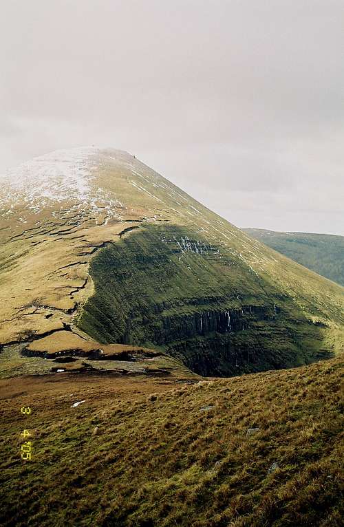
Galtymore’s north flanks, as well as three glacial lakes: Borheen Lough, Lough Dineen and Lough Curra. These three dark, quiet lakes seem to have an air of mystery about them. They also contain arctic char, fish deposited in the lakes during the last ice age.

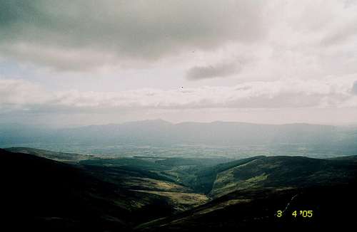
Why climb Galtymore? If you’re a peakbagger, you can tick off one on your list of “Irish Munros” – peaks in Ireland attaining 3000 feet. As mentioned earlier, Galtymore is also a two-fer county high point and is also the fourth most prominent summit on the isle of Eire. For those of you out for a nice day on the hills, Galtymore has a lot to offer. Finicky and often severe weather, steep hills (some in excess of 35% grade), impressive cliffs and deep dark lakes. The views from the summit on a clear day also seem to stretch forever.
Getting There
The Galtees are a small range; about 20 km east to west and 8 km north to south, so there are many approaches. The N8 is the main highway, cutting through the Galtees to the north and the slightly shorter (794m)
Knockmealdowns to the south. Mitchelstown is at the west end of the Galtees on the N8, Cahir on the east end of the N8. There are three main access points. Relations between hillwalkers and farmers are still good here, so please stick to these three. Below are directions to the three points:
Southern access #1: Youth hostel.
From either Mitchelstown or Cahir, drive on the N8 towards the opposite town. About 12 km north of Mitchelstown or 13 km south of Cahir, head north just south of the Burncourt River crossing. There is a parking area about 200m north of here. Depending on vehicle clearance, you may also drive to the hostel, 2 km north on a dodgy road (not sure of the condition, I haven’t approached this direction). From here it’s about 7 km to the summit, with about 720m elevation gain one way via a network of paths and bog trotting.
Southern access #2: The Black Road
From the Kilbeheny post office on the N8, drive east 5 km then turn north on a paved road. Take until it dead ends, about 3.5 km. Park. From here you follow a path roughly north, but you’ll need to divert NW after 3-4 km across some bog to get to the summit. A map and compass help here, or a GPS…especially in foul weather. One way from the Black Road TH gives roughly 4.7 km with 600m elevation gain.
Northern access: Cush approach
From Mitchelstown, take R513 north about 6.5 km to a turnoff towards Anglesborough. Go through this town (blink and miss it), following the country road 5 km to the Barna Cross Roads. Turn right here, and proceed about 5.5 km to the Clydagh bridge, where you’ll see signs for the Galtymore climb. Park here. There’s a bit of information on a plaque there, as well as a sign requesting that no dogs be taken on the mountains to avoid disturbing livestock.
Red Tape
A prominent sign at the start of the northern approach forbids dogs. Landowner-hillwalker relations are still quite good here; please keep it that way and leave your pooch at home. Otherwise, respect the land and enjoy yourself.
Camping
Camping isn't necessary; the Galtees are a small range and can be covered in a day. The range is also on private land, so I'm not sure that camping would be welcomed with open arms.
External Links
Simon Stewart maintains MountainViews, an excellent page cataloging all Irish summits over 500 meters. The link to Galtymore itself is here, and has a few pictures of Galtymore that are much nicer than mine (especially the winter images).
Crappy Pictures Alert!
My digital camera was on the fritz during my visit to Galtymore, and so my images were captured by a 35mm camera with condensed vapor in the lens. Anyone with better images is encouraged to submit!
Challenge Walk
There are several "challenge walks" around Ireland every year, and the Galtees has one of its own each June. It generally involves a 24 km (15 mile) walk with about 1600m (5200 feet) elevation gain. Pretty tame as far as challenge walks go but you'll still break a sweat.
For more information, see this site