
|
|
Mountain/Rock |
|---|---|
|
|
44.33685°N / 118.8887°W |
|
|
Grant |
|
|
Hiking, Scrambling |
|
|
Summer, Fall |
|
|
7999 ft / 2438 m |
|
|
Overview
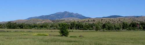
Canyon Mountain looms over the settlements of Canyon City and John Day, Oregon. It is the westernmost summit of the Strawberry Mountains, which are a sub-range of the Blue Mountains of eastern Oregon.
Although now residing at 7999 feet above sea level, the rock comprising Canyon Mountain once resided below the ocean floor. Canyon Mountain is composed of gabbro and greenstone that is underlain by peridotite. These rocks are about 275 million years old. According to Bishop, the gabbro here is believed to represent the magma chamber of an island arc volcano. The peridotite is representative of the Earth’s upper mantle. This sequence of rocks is known as an ophiolite complex, and it has since been accreted to the advancing North American continent and been uplifted by a compression of the Earth’s crust. Several million dollars of chrome ore were mined from the peridotite here in the first half of the twentieth century. The arêtes, cirques, U-shaped valleys, and hanging valleys here were produced by glaciers.
Gold was found in placer deposits at Canyon Creek in 1862, and brought a rush of gold miners to the slopes of Canyon Mountain and to the boomtown of Canyon City.
The forest is mostly lodgepole pine, ponderosa pine, and Douglas fir with a few junipers at the lower elevation beginning of the trail. The wild strawberries for which nearby Strawberry Mountain were named are also found here. The Canyon Mountain area provides habitat Rocky Mountain elk, deer, bear, bobcat and coyotes. There has been an effort to reintroduce bighorn sheep here, but the sheep population has been eliminated by disease.
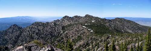
The summit features a benchmark, summit register dating back to the early 1970’s, and an excellent view. The view from the summit includes the John Day Valley, the remainder of the Strawberry Range, The Aldrich, Elkhorn and Greenhorn Mountains, and on a clear day the Wallowas. Judging by the Summit register, Canyon Mountain is usually climbed by fewer than 20 parties a year.
Canyon mountain is located in the western portion of the Strawberry Mountain Wilderness. There is no trail access to the summit, but the Canyon Mountain Trail Crosses its northern flanks. This trail features a few open meadows where wildflowers bloom after the snow melts. The shortest non-technical way to the summit is via Dean Creek. This route is about 13.5 miles round trip and gains 2600 feet in elevation. An ascent via Dean Creek is an easy class 3 scramble. A more challenging yet still non-technical route of ascent is via the northeast ridge. Another route that is longer but more scenic and gently graded is the one recommended by Bond. This class 2/3 route follows the Canyon Mountain Trail an additional mile beyond Dean Creek and follows a ridge over a few highpoints including Green Mountain. Round trip distance via this route is 17.6 miles and has a cumulative elevation gain of 4674 feet.
Getting There
First, you will need to find your way to John day, Oregon.From The junction of US Highway 26 and US Highway 395 in John Day, take US 395 south for approximately 2 miles. Turn left onto County road 52 (Marysville Road) in Canyon City. Drive 1.9 miles, and then take a right on County road 77. After approximately 0.3 mile, take another right on Forest Service Road 7700-333, where there is a sign for Canyon Mountain Trail #218. Drive approximately 2.7 miles uphill to somewhat of a four-way junction (the left turn will be slightly uphill) ignoring any less traveled side roads. At this point, you should have traveled 6.7 miles from the junction of US 26 and US 395. Turn left here and drive about 0.1 mile to the trailhead, where there is a brown forest service sign that says nothing. The coordinates for the trailhead are 44.3625°N, 118.9261°W (NAD27).
Red Tape
As of June 2006, there were no signs at the trailhead stating that a permit of any kind is needed.Camping
There are a few good spots at Dean Creek where you can camp.Lodging is available in nearby John Day.
Conditions
Malheur National ForestBlue Mountain Ranger District
P.O. Box 909
John Day, OR 97845
(541)575-3000