
|
|
Mountain/Rock |
|---|---|
|
|
39.40519°N / 120.62829°W |
|
|
Nevada |
|
|
Hiking |
|
|
Spring, Summer, Fall |
|
|
7490 ft / 2283 m |
|
|
Overview
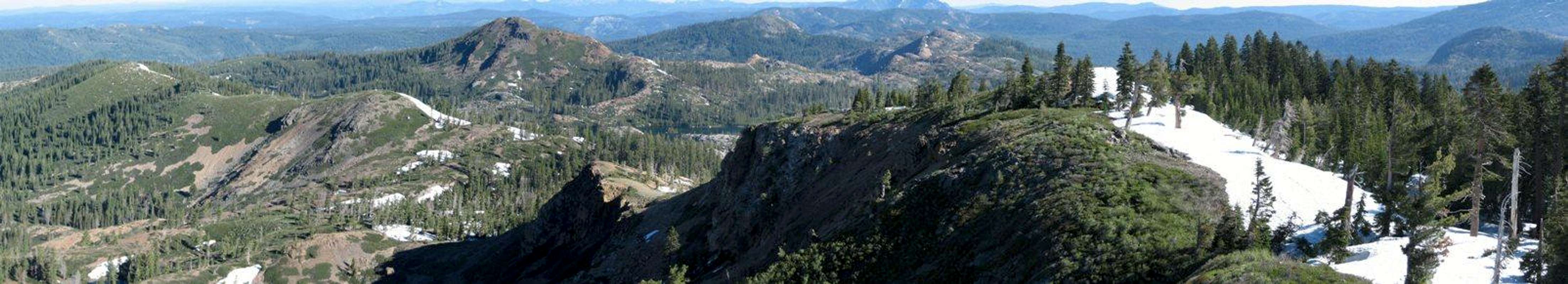  |
Fall Creek Mountain is located in the Tahoe National Forest between Bowman and Spaulding Lakes. It is nestled in the Grouse Ridge area and is surrounded by many charming alpine lakes, smooth granite and forested slopes. The forest is typical upper montage, consisting of Red Fir and Lodgepole Pine trees. The area really is a gem, but due to its relative easy of access, expect to share it with others.
The peak itself is an easy class 2 climb from either the west or east ridges or the south face. For those looking for more climbing adventure, both the east ridge and south face have some potential easy class 3 sections. They can, however, be easily bypassed. The peak would make a nice easy dayhike for those not yet into peak climbing.
While Fall Creek Mountain is not the tallest peak in the area (that title belongs to Black Butte), it's vista's compensate. Being situated 14 or so miles from the Sierra Crest, the summit views take in most of the major peaks in the area. On a clear day, Lassen Peak is visible to the north and the major peaks of Desolation Wilderness can also be seen. Of course, many Sierra peaks ranging from the Sierra Buttes to Castle Peak to Granite chief are also visible.
Given the fact that the main access road (Bowman Lake Road) is not plowed in the winter, most ascents are made in the summer and fall months. There are restrictions on snowmobiles and OHV in the Grouse Ridge Vehicle Closure Area.
Getting There and Trailheads
The most direct route to the area is via the Bowman Lake Road. Take Hwy 80 from either the west (Sacramento/Bay Area) or East (Reno) and exit at exit #161- SR 20/Nevada City. The signage on the interstate is well noted. Head west on Hwy 20. After approximately 4.2 miles, take a right on Bowman Lake Road. Continue north on this road for another 8.25 miles, passing Fuller Lake on the right.Carr Lake Trailhead.
Drive on Bowman Lake Road for 8.25 miles until you reach an intersection for Carr Lake. Take a right and continue on the dirt road to the trailhead (another 2.75 mi). The road is generally in good shape and should be passable by passenger vehicles. High clearance is not required, except in the late spring when there can be sizeable snow drifts. There is plenty of parking and a campground at the trailhead. The peak from this trailhead is a very easy 2 miles via the southeast ridge and only 800 feet of elevation gain.
Grouse Ridge Trailhead
As an alternate, one can begin hiking from the Grouse Ridge area which is to the southeast of the peak. To reach this trailhead, follow the above directions. Once on Bowman Lake Road, drive 6.25 miles to the intersection of the Grouse Ridge Road. Again, the road is a well maintained dirt track that is easily navigable in a passenger car. Drive the 5 miles or so to the trailhead. There is plenty of parking and a small campground. The trail from Grouse Ridge descends 700 feet, heading to the northeast and passing by Milk Lake before turning westward towards the peak. Total roundtrip distance is about 7 miles and elevation gain is about 700 feet up to the peak and another 700 feet back up to the trailhead.
Red Tape
The peak lies within the Tahoe National Forest. There are few restrictions to abide by. You will however need to obtain a campfire permit for any open flames, including gas stoves and BBQ's. These permits can be picked up at any ranger station.A list of ranger stations can be found here at Tahoe National Forest- Ranger Districts. According to the Tahoe National Forest's website, one permit is valid for any location in the forest and is good for one year.
Camping
There are three National Forest campgrounds in the immediate area. The most accessible one is at the primary trailhead, Carr Lake. Another is at the Grouse Ridge trailhead and the third is located at Lindsey Lakes, slightly further up Bowman Lake road.Campground Information
| Campground | # of Sites | Fee | Water | Toilets | Elevation | Comments |
|---|---|---|---|---|---|---|
| Carr Lake | No Fee | lake-boil | Vault | 5,900' | Walk-in sites | |
| Grouse Ridge | No Fee | None | Vault | 7,400' | Typically Closed until Early July | |
| Lindsey Lake | No Fee | lake-boil | Vault | 5,900' | . |
Information on camping can be found at the Tahoe National Forest- Camping website.
Additional information on camping and the forest in general can be found on the publications page of the same site.
Mountain Conditions
Current conditions can be found on the Tahoe National Forest- Conditions webpage. The snow melt report is particularly helpful if you plan of heading out in the early spring.If you plan on heading to the area in winter, keep in mind that avalanches are a distinct possibility. Check the Sierra Avalanche Center for more information.