
|
|
Mountain/Rock |
|---|---|
|
|
36.77400°N / 118.716°W |
|
|
Fresno |
|
|
Hiking, Bouldering, Scrambling |
|
|
Summer, Fall |
|
|
8531 ft / 2600 m |
|
|
Overview
Lookout Peak is on the border of Sequoia National Forest and Kings Canyon National Park. Immediately to the north and east of Lookout Peak is the glacially carved Kings Canyon. From the top of Lookout Peak you have a splendid view looking right down into Kings Canyon, similar to the view you get of Yosemite Valley from Glacier Point. Unlike Glacier Point, though, chances are you'll have Lookout Peak all to yourself if you visit.
In a recent article in the San Francisco Chronicle, the hike to Lookout Peak was named one of the top 5 "Hikes to Prettiest Views" in the entire state of California! It rated as #4. Click here to read the article.
Getting There
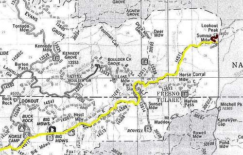
Lookout Peak is accessible from the Big Meadows Road (Forest Road 14S11) off of the General's Highway. The Big Meadows Road takes off from the General's Highway almost exactly half-way between Grant Grove in Kings Canyon National Park and Lodgepole in Sequoia National Park. Take Road 14S11 about 15 miles northeast. It is mostly paved but will turn to dirt so a high clearance vehicle is recommended. Within 1/4 mile of the road's end where the road turns south is large dirt turnout and from here it is a short but steep 1/2 mile to the top of the peak where you'll see a couple of radio towers. The route to the top is via a non-maintained trail that switchbacks a couple of times and then with a little bit of rock scrambling you can get to the very top.
You can also hike to Lookout Peak on the Don Cecil Trail which originates in Kings Canyon. The roundtrip hike is about 14 miles and climbs 4,000 feet and goes back down again.
Red Tape
There is a $20 fee charged for entrance into Sequoia & Kings Canyon National Park. This fee will get you a pass good for 7-days. You can also buy a $80 America the Beautiful Federal Lands Recreation Pass good for entrance to all National Parks, National Forests, BLM, US Fish & Wildlife, and Bureau of Reclamation sites for one year from date of purchase. If you're disabled, you may want to get an Access Pass which are free and good for a lifetime. If you're 62 years of age or older, a Senior Pass can be purchased for $10 and they're also good for a lifetime. Click here for more info on fees and passes.
Please practice Leave No Trace ethics during your visit to Lookout Peak to help preserve this beautiful area.
Camping
The nearest campground is Big Meadows. It does not have potable water so bring your own!
You can also disperse camp in Sequoia National Forest. Don't drive off road, bring your own water, and pack out what you pack in! You'll need a campfire permit if you plan on having a campfire or charcoal barbeque. They can be picked up free of charge from any Forest Service, BLM, or CA Department of Forestry office.
If you don't feel like roughing it, there is a historic cabin you can rent at Big Meadows. It rents for $100/night and has electricity, a woodstove, a bathroom complete with hot shower, a kitchen with refrigerator and stove/range, and sleeping room for 6 people.

Campsite at Big Meadows
External Links
Link to the webcam at Buck Rock that's pointed towards Lookout Peak
Link to my friend Cris's great photos of his hike to Lookout Peak on the Don Cecil Trail
Sequoia National Forest & Giant Sequoia National Monument
Sequoia & Kings Canyon National Parks
Tulare Mountains Weather Forecast
Yosemite to Kings Canyon Weather Forecast
Etc.
Native Americans traveled to Kings Canyon via a route that the Big Meadows Road now follows then connecting with what is now the Don Cecil Trail. Nowadays visitors to Kings Canyon drive on Hwy 180 which follows the river east into the canyon. This road was tough and expensive to build due to the rugged and rocky canyon terrain. The route via Big Meadows follows gentler terrain and is the more natural route.
Nearby Buck Rock is a fun place to visit. Also, there are several nearby giant sequoia groves that hardly anyone visits. The Evans Grove is a nice one and you can access it via trail 13S25 (see map above).
A great jumpoff point for backcountry hikes is from the Rowell Meadow Trailhead (see map above).
Visit nearby Horse Corral Packstation if you'd like to go for a horseback ride or backcountry pack trip!

Giant Sequoias in the Kennedy Grove

Buck Rock