|
|
Mountain/Rock |
|---|---|
|
|
40.74700°N / 110.81944°W |
|
|
Hiking, Mountaineering, Scrambling |
|
|
Summer, Fall |
|
|
12284 ft / 3744 m |
|
|
Overview
East Hayden Peak is actually an unnamed mountain on the USGS topo maps. The name 'East Hayden Peak' is given in relation to its popular neighbor 'Hayden Peak'. East Hayden Peak is a rugged and beautiful mountain located in the western region of the High Uinta Wilderness. The mountain's location forms a sharp division between the the West Basin and the Middle Basin of the Stillwater Fork. From the summit you have an incredible view of the surrounding basins and lakes, and a great panoramic view of Hayden Peak, Kletting Peak, A-1 Peak, Mount Agassiz, Spead Eagle Peak, Ostler Peak, and Lamotte Peak. East Hayden Peak's location gives it a secluded, remote feeling although it can be climbed as a single day trip.East Hayden Peak can be approached as a single day trip or a backpacking trip. The day trip route climbs the Hayden/Agassiz Ridge, from the Mirror Lake area, then ascends the south ridge. The backpacking route follows the Stillwater Fork and ascends the north ridge.
East Hayden Peak is within the jurisdiction of the Kamas Ranger District of the Wasatch-Cache National Forest.
Click for the Full Trip Report on my photography website.
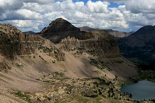
![East Hayden Peak]()
View of East Hayden Peak from the Hayden/Agassiz Ridge.
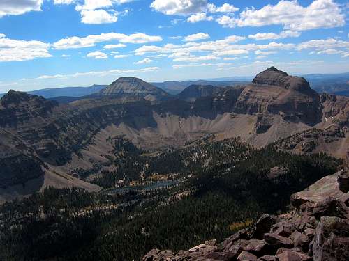
![A-1 Peak Summit View]()
View of East Hayden Peak (far left) from the summit of A-1 Peak.
To reach this Highway use the following instructions: from Salt Lake City, go south on Highway 40 out of Park City. From Provo, go north on Highway 40 out of Heber City. On Highway 40, go to the Park City/Kamas Exit (exit 4). At the stop sign turn right (onto Highway 189), and go roughly 12 miles to the town of Kamas. In Kamas, follow the road to Center Street and turn right (east) onto Highway 150. Highway 150 is the Mirror Lake Highway and will take you up into the Uinta Mountains.
If you wish to travel the backpacking route through the Stillwater Fork, the trailhead begins at Christmas Meadows. To reach Christmas Meadows, take Utah Highway 150 (Mirror Lake Highway) into the Uintas. Travel 0.6 miles south of Bear River Ranger Station, and you will see an east exit off the highway onto a dirt road. A sign at that exit reads "Christmas Meadows". Simply follow this road to a small parking lot at the Christmas Meadow Campground. The majority of the road is well-maintained, but the last half-mile gets a little rough.
If you wish to travel the single day trip route, take Utah Highway 150 (Mirror Lake Highway) to the Highline Trailhead which is roughly 1/4 to 1/2 mile north of Mirror Lake. There is a large sign on the side of the road marking the parking lot to the trailhead.
Fees are $3.00 per day, $6.00 per week, or $25.00 annually.
(text borrowed from Joseph Bullough's A-1 Peak mountain page).
![East Hayden Peak - south ridge route]()
Camping terrain in the Middle Basin of the Stillwater Fork. East Hayden Peak on the left.
(text borrowed from Joseph Bullough's A-1 Peak mountain page).
View of East Hayden Peak from the Hayden/Agassiz Ridge.
View of East Hayden Peak (far left) from the summit of A-1 Peak.
Getting There
East Hayden Peak is most accessible from the Utah Highway 150 (Mirror Lake Highway) that travels through the western region of the Uinta Mountains.To reach this Highway use the following instructions: from Salt Lake City, go south on Highway 40 out of Park City. From Provo, go north on Highway 40 out of Heber City. On Highway 40, go to the Park City/Kamas Exit (exit 4). At the stop sign turn right (onto Highway 189), and go roughly 12 miles to the town of Kamas. In Kamas, follow the road to Center Street and turn right (east) onto Highway 150. Highway 150 is the Mirror Lake Highway and will take you up into the Uinta Mountains.
If you wish to travel the backpacking route through the Stillwater Fork, the trailhead begins at Christmas Meadows. To reach Christmas Meadows, take Utah Highway 150 (Mirror Lake Highway) into the Uintas. Travel 0.6 miles south of Bear River Ranger Station, and you will see an east exit off the highway onto a dirt road. A sign at that exit reads "Christmas Meadows". Simply follow this road to a small parking lot at the Christmas Meadow Campground. The majority of the road is well-maintained, but the last half-mile gets a little rough.
If you wish to travel the single day trip route, take Utah Highway 150 (Mirror Lake Highway) to the Highline Trailhead which is roughly 1/4 to 1/2 mile north of Mirror Lake. There is a large sign on the side of the road marking the parking lot to the trailhead.
Red Tape
All motor vehicles parked along Utah Highway 150 (Mirror Lake Highway) must display a valid recreation pass. These passes may be purchased at the trailead (self-service), or at various other self-service locations along Highway 150.Fees are $3.00 per day, $6.00 per week, or $25.00 annually.
(text borrowed from Joseph Bullough's A-1 Peak mountain page).
Camping
The closest official campgrounds are Christmas Meadows on the north side, and Mirror lake and Moosehorn on the west side. Backcountry camping is permissible on all flanks of the mountain. A particular favorite is the Middle Basin which includes McPheters Lake and Ryder Lake. This area is a slice of heaven!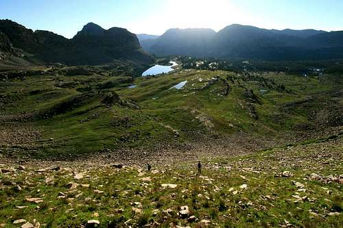
Camping terrain in the Middle Basin of the Stillwater Fork. East Hayden Peak on the left.
Mountain Conditions
Links to local weather, road conditions, and fire information can be found on the Wasatch-Cache National Forest website.(text borrowed from Joseph Bullough's A-1 Peak mountain page).