
|
|
Mountain/Rock |
|---|---|
|
|
38.95267°N / 77.07686°W |
|
|
Hiking |
|
|
Spring, Summer, Fall, Winter |
|
|
409 ft / 125 m |
|
|
Overview
Probably the only highpoint, to which you can take a subway. I wasn't sure if I should classify this as hiking, but that was the least strenuous of the choices. The climb out of the subway was pretty grueling. :oP
At 409 ft., Fort Reno really does stand high above most of Washington, DC, which is mostly around 20 ft. above sea level.
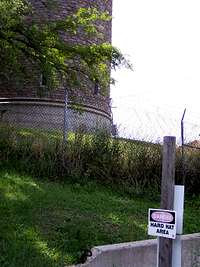
It is supposedly in a National Park; however, most of the highpoint is operated by the District of Columbia Department of Transportation. The DOT portion is off limits and surrounded by no trespassing signs and barbed wire.
In 2007, the Highpointers Club in conjunction with the National Park Service had Fort Reno surveyed for the highest natural point of land within Fort Reno Park. The result was a new USGS-style survey marker dated 2007 that is in an open field off of Nebraska Avenue NW between Wilson High School and Deal Junior High School. The official height of the DC highpoint at Fort Reno is 409 feet, which is about 20 feet lower than the artificial highpoint of approximately 429 feet in the area of the reservoir.
A ceremony was held in April 2008, commemorating this updated HP location. For details, Click Here to find this information, map, and several photos.
Washington, D.C. is considering officially naming the HP as "Point Reno". This name ("Point Reno") is already shown on the newer disk/marker that was created by the D.C. Association of Land Surveyors and the Highpointers Club in 2007.
Getting There
Red Line to Tenleytown-AU. Once you are out of the Metro, turn left (North) on 40th St. Head to the right of the soccer field in Fort Reno Park and turn left on a gravel trail.
This will take you around the fenced off portion of the park and near the Department of Transportation salt depot. Go up to the gate, and you are at the natural highpoint.
There is an earthen mound that encloses a reservoir, which rises about 8 ft. higher, but it is closed off from the public.
Puma Concolor provided the following directions to the National Park Service marker:
"OK, this thing was surprisingly easy to find. I was expecting to be doing a grid search in the middle of a flat field but it was nothing like that.
If you have the first quarter 2007 Apex to Zenith, the map on the cover was very useful once you figured out which streets were depicted on the small map. If you don't have the A to Z issue (or even if you do), this link really helps you zero in on things:
Click Here
In terms of directions, I'm going to use the intersection of Wisconsin and Nebraska (in the Northwest quadrant of DC) as the main point of reference. From this intersection, which basically forms an "X", head northeast on Nebraska (driving up the upper right portion of the "X"). As you drive northeast, the first intersection you pass will be with Albemarle Street NW. You will then pass Wilson High School and its large outdoor track/football field on your left. Next is the intersection with Chesapeake Street NW.
After you pass Chesapeake, look to your left and you will see the open field for which you're looking. I passed by the field and turned left onto Fort Drive NW, which is really just the entrance for Deal Junior High School. As long as school is out, parking along Fort Drive is no problem. Then just basically walk WSW up the small hill (with the Junior High at your back and angling away from Nebraska). The 2007 marker is huge by USGS standards and is a "can't miss" type of thing.
Please note that if you're driving southeast on Wisconsin from I-495, you cannot turn left onto Nebraska so you'll have to figure out a way to get yourself pointing the right way on Wisconsin or make a few turns and work your way over to Nebraska. If you hit it at the wrong time, traffic can be a nightmare in this area. Off hours are best for your visit.
Also, even though the "artificial" area along the reservoir is not the true natural HP, it's not a bad idea to visit it IMO. It really feels more like the HP than where the marker is even if there is a crappy fence along the artificial "summit plateau." Lots of folks seem to do this as there is a well-worn path around the fence.
Let's be safe out there."
Directions from I-495
1) From I-495, head south along Wisconsin Avenue for nearly five miles.
2) Take a left at Albemarle Street NW. A "Tenleytown-AU" indicator is located near this intersection.
3) Drive two blocks. Then take a left onto Nebraska Avenue NW.
4) Fort Reno Park will be on the left side of the road, within a few blocks.
For driving, this appears to be the most direct route to the HP, with only two turns needed from the Interstate.
Red Tape
A barbed-wire fence surrounds most of the highpoint, but there is a small section near the Department of Transportation's salt dome where one can reach ground equal to that inside the fence.

Camping
Probably not allowed or desired, but who knows.
External Links
National Park Service - Fort Reno
rematore - Nov 25, 2007 10:59 am - Hasn't voted
Re: National Park Service markerThanks Puma!! I tried to incorporate your information.
Redwic - Aug 5, 2008 9:27 am - Hasn't voted
Directions from I-495...1) From I-495, head south along Wisconsin Avenue for nearly five miles. 2) Take a left at Albemarle Street NW. A "Tenleytown-AU" indicator is located near this intersection. 3) Drive two blocks. Then take a left onto Nebraska Avenue NW. 4) Fort Reno Park will be on the left side of the road, within a few blocks. For driving, this appears to be the most direct route to the HP, with only two turns needed from the Interstate.
Redwic - Aug 5, 2008 9:36 am - Hasn't voted
Info About The Summit Marker...Several things worth noting: 1) Washington, D.C. is considering officially naming the HP as "Point Reno". This name ("Point Reno") is already shown on the newer disk/marker that was created by the D.C. Association of Land Surveyors and the Highpointers Club in 2007. 2) Speaking of which, SP member "Puma concolor" is correct. The actual surveyed highpoint is at a much different location at Fort Reno Park than the reservoir (and from where people had been going previously). A ceremony was held in April 2008, commemorating this updated HP location. For details, visit http://highpointers.org/archives/2008/01/28/dc-2/ to find this information, map, and several photos.
rematore - Sep 28, 2008 12:11 am - Hasn't voted
Re: Info About The Summit Marker...Thanks. Just updated it.