
-
 31202 Hits
-
 82.48% Score
-
 15 Votes
|
|
Mountain/Rock |
|---|---|
|
|
36.10690°N / 82.1036°W |
|
|
Carter |
|
|
Hiking |
|
|
Fall |
|
|
5826 ft / 1776 m |
|
|
Overview
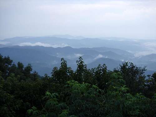
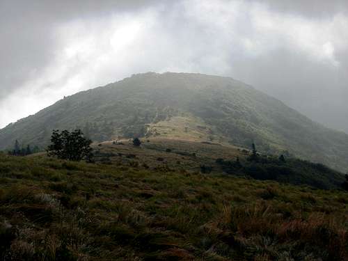
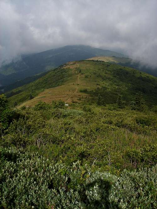
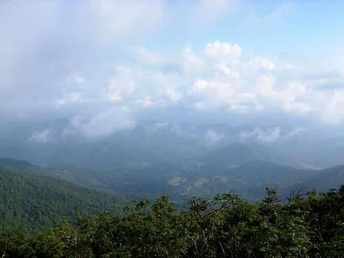
Round Bald raises its crown above Carvers Gap (5512’) on the border of Tennessee and North Carolina. Just a ½ mile from Highway 143, the hill is a popular destination for visitors to the Roan Mountain area. The Appalachian Trail traverses its summit, where breathtaking views can be had in all directions. On a clear day, one can see north into the Virginia highlands, west to the Clinch Mountains and plains of Tennessee, east to Mount Mitchell and the Black Mountains, Grandfather Mountain, Sugar Mountain and beyond. South lies 6285’ Roan High Knob.
Round Bald is the first of a series of balds and grassy ridges that extend north to 5587’ Hump Mountain. This is one of the most scenic parts of the Appalachian Trail, a welcome change for thru hikers from the thick broadleaf forests that lie north and south.
Dr. Elisha Mitchell, a professor at the University of North Carolina (for whom Mt. Mitchell, the highest peak east of the Black Hills is named) once said, "[Roan Mountain] is the most beautiful of all the high mountains. The top of the Roan may be described as a vast meadow without a tree to obstruct this prospect, where a person may gallop his horse for a mile or two with Carolina at his feet on one side and Tennessee on the other, and a green ocean of mountains rising in tremendous billows immediately around him" (1836).
No doubt he had the slopes of Round Bald in mind when making this claim.
Getting There
Tennessee – From Interstate 26 in Johnson City exit US Highway 321 to Elizabethton. Follow 321 to 19E (in Elizabethton) and turn right. Take 19E southeast to Roan Mountain. Turn right on Highway 143 in Roan Mountain. Follow 143 south to Carvers Gap. A parking lot is located on your right.
North Carolina – From Asheville take the Blue Ridge Parkway to 226 North (NE of Little Switzerland).
Take 226 to Bakersville and turn north on 261/143. Take 261/143 to Carvers Gap. A parking lot will be on your left.
This mountain is extremely accessible. This makes it a somewhat crowded destination. The path up Round Bald was recently improved. Covered with coarse gravel, it winds gently up the western slope to the summit. On the way, visitors pass through the remnants of an old conifer forest.

When To Climb
In mid-June, Rhododendrons bloom throughout the Roan Mountain region, most spectacularly at the Rhododendron Gardens near Tollhouse Gap, 2 miles from Round Bald.
The best vistas can be had in autumn when the moisture is retained in the forest floor. In summer, clouds, rain and haze often obscure the horizons. In late July, flies, bumblebees and honeybees are common on the balds.
Camping
Backpackers and hikers can camp at designated spots along the trail. There is an AT shelter located on Roan High Knob. The Stan Murray Shelter, which sleeps 8 people, sits 3 miles northeast. The Overmountain Shelter, some 5 miles northeast at Yellow Mountain Gap, sleeps 40 and is the largest on the Appalachian Trail.
Camping is also located nearby at:
Roan Mountain State Park
1015 Hwy. 143
Roan Mountain, TN 37687
423.772.0190
www.tnstateparks.com
Red Tape
No permits required. Be advised that vehicles parked at Carver's Gap have been vandalized in the past. It is not wise to leave your car unattended for long periods of time or overnight.
Weather
Please note temperatures on top of Round Bald are at least 5 degrees cooler than in Boone. Cloud cover is common even when most of the region is sunny.
Boone, North Carolina weather forecast.

Eleutheros - Aug 26, 2006 2:48 am - Hasn't voted
Re: weatherLink is good now. Added a little about accessibility and path improvement. Thanks!