
-
 50423 Hits
-
 94.02% Score
-
 45 Votes
|
|
Mountain/Rock |
|---|---|
|
|
47.28800°N / 113.87°W |
|
|
Hiking, Mountaineering, Trad Climbing, Scrambling, Skiing |
|
|
Spring, Summer, Fall, Winter |
|
|
9001 ft / 2744 m |
|
|
INTRODUCTION & OVERVIEW
less than ideal conditions, or when snow is present."
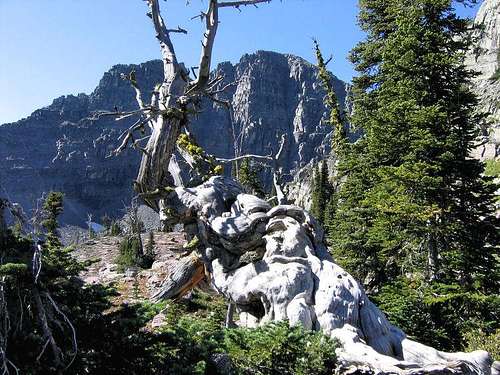 White Pine & the East Face
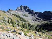
South Face
Those two sentences are how Pat Caffrey chooses to begin the page on this mountain in Climbers Guide to Montana (now out of print); they should get your attention, and with good reason:

Nearing the NE summit ridge
Gray Wolf Peak, by any criteria I know of, is magnificent! Even within the Mission Range, which certainly has no shortage of exceptional mountains, this one is special. Nothing of the true peak is visible from any road to the north or west, but from the south you see a rather distant, enticing, entrancing view of the false south summit, which

Looking past the north face
shows itself, along with some worthy southern Mission companions—first seen at approximately the point at which you enter the Flathead Indian Reservation (there is a sign informing you of this boundary)—for a few miles during the drive north on Hwy 93 towards the town of Arlee, before the whole lot disappears behind ridges, and closer and lower mountains. But what you've seen has been enough, and...(choose your own words here) "the seed has been planted," "the damage done," or maybe, "there's just no help for it:" here is a thing stays in your mind for future climbing reference. It is now highlighted on your "to do" list.
 Gray Wolf's east face, from Upper Scenic Lake
Lowary Peak and Peak Y
There are certain aspects to climbing Gray Wolf which should be understood at the outset, two of which are, for a non-technical mountain it is neither easy nor straightforward, and it is a long day. In good weather it is not quite—but almost—technical, with a choice of several different options, making route-finding a challenge

Looking NW to McDonald Peak
necessary to successfully cultivate. This mountain is not for the inexperienced, and I've never climbed a peak on which I'd less rather get caught in bad weather. Another thing is that if you are doing this around the end of August you'll have to deal with huckleberry patches, which have a tendency to slow both ascent and descent (most of us feel they're worth it). And besides all that, bring your camera—you'll use it on this one.

Neighbors East Saint Marys and Lowary.
Gray Wolf is the southernmost major peak in the Mission Range, slightly more so than its closest neighbor, East Saint Marys Peak (both mountains have stunning views of each other), and shows an excellent vista to several others of the high Missions—McDonald, Mountaineer, and Lowary Peaks are immediately,

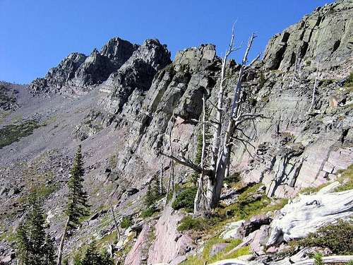
Colorful rocks, but not a couloir to descend!
impressively, front and center, as well as many, many other summits of varying elevation stature. It is obvious from the barren and scoured rock that the Continental Ice Sheet, and its offspring glaciers, have left this area only comparatively recently, and, in addition to the carved terrain, were responsible for the creation of a great many lakes. Gray Wolf Lake is the area's biggest, and is quite large, but there are many,

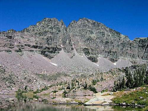
Same basin, different perspective of south face...
many more; the two basins we traversed each had a pair, and as we climbed it became an unfolding vista of yet more lakes, and forests and mountains. There is also an old, sad glacier dying on the north side; Gray Wolf Glacier now looks at times to be only a large snowfield, although, like an iceberg what is visible is only a small percent of an unseen—underground—remnant.

Mountaineer Peak
An interesting aspect of this immediate area of the Missions (including both Gray Wolf and East Saint Marys) is usage for winter activities. Both peaks are accessed via the same road from Saint Ignatius, and it is possible to get within hiking or skiing distance of the Twin Lakes Recreation Area

East Saint Marys Peak
via 4WD, plus the road is open to snowmobiles. See the ESM page for information on winter usage in that area, but Gray Wolf is also used, only quite differently. By those individuals with the necessary skill, desire, and capacity for adrenaline rushes, both the south couloir and west face are used for X-treme skiing! I suppose anyone likely to do this sort of thing is aware of the potential on peaks like this, but avalanche danger in the area is extreme, resulting, in 1998, in the death of an individual—not skiing, but on snowshoes—in the vicinity of the south couloir and Upper Riddell Lake.
GETTING THERE

SE perspective of East Face
The mountain itself is wonderful to look at from any angle, but that doesn't provide climbers with anything more than motivation, and what information can be gleaned by studying the cliffs and couloirs. First you must get there. There are no trail signs in the Mission Mountains Tribal Wilderness, but in this instance the trail is quite good—once you find it. From Twin Lakes (the approximate point and elevation at which you leave your vehicle) to the summit is slightly less than 5000 feet elevation gain; that's enough on its own, but according to the Montana National Geographic CD-ROM Topo Map, by the time you deal with the natural ups and downs of the terrain, plus ascend and descend through two basins, elevation gain for the day on the route we took is in the vicinity of 6500 feet. So you really do want the trail; bushwhacking would be a monster! Anyway, pay attention, and I'll help you with this.
 Enticing afternoon light on a possible route...
Gray Wolf slides into view while ascending East Saint Marys Peak
Follow U.S. Hwy 93 until reaching Saint Ignatius, then take the main turnoff (where you turn, there’s a Sinclair gas station, museum, cafe, and fruit stand on the west side of the highway); go east through town for .3 mile until reaching a "T" junction, whereupon there is no choice but to go either right or left; go right for about a block, cross the small bridge, and immediately turn (at an angle) left. Stay on that street another .3 mile until coming to a stop sign, where you once again must go either right or left, and—again—go left. You are now on the St. Mary’s Lake Rd. After 2.1 miles take a 90 degree right turn (the road is signed, but it’s easy to miss them first time around); after another mile the road takes yet another 90 degree turn, only this time it’s to the left, and now you’re set—no more tricks. Continue two more miles (still St. Mary’s Lake Rd, remember) until the pavement ends, turning into a good gravel road; at that point it is almost exactly 6 miles to Twin Lakes Recreation Area, which is your first serious point of reference (and where, if you have a Reservation Camping Permit—see "Camping & Lodging" section below—you can camp). The Twin Lakes Recreation Area is marked by this sign:
 Twin Lakes Recreation Area —
As of 2012, there was a ROAD CLOSED sign over the sign shown above. Use the following directions from this point: Pass the "Road Closed" sign on your left and continue another mile or so at which point the road Y's. Turn left here and as you turn, you'll notice another Twin Lakes Recreation Area sign on your left. Follow this road down the hill and across a bridge. Turn right immediately after this bridge and follow this road a few hundred yards until you see the logging road closed off by three large boulders. Park here and hike about a mile up this road to the trail, which heads off steeply to the right. The above update is courtesy of SP member urnotreal. (Thank you!) Now...check out the Northeast Ridge Route page, to get the rest of the way.
THE RED TAPE, WILDLIFE, & CAUTIONS SECTION
HIKING PERMITS Most of the western half of the Mission Range—this includes Gray Wolf Peak—is on the Flathead Indian Reservation (also known as the Confederated Salish and Kootenai Tribes—"Flathead" and "Salish" are one and the same), and a Reservation Hiking Permit is required. These are easy to obtain at sporting goods stores throughout the Mission and Flathead Valleys, as well as Missoula and Thompson Falls, or throughout the Seeley-Swan Valley on the range's eastern side—or you can call the Confederated Salish and Kootenai Tribal Recreation Department in Pablo, at (406) 675-2700. The license is $15 per season, and expires every year on the last day of February—whether you purchase yours in March, May, or December, it expires the end of February. (See also "Camping & Lodging" for information on camping permits.) McDONALD PEAK GRIZZLY CLOSURE AREA Another important, and unusual, detail to know about the Missions—which in this case does NOT specifically affect Gray Wolf Peak, but is important enough to mention anyway—is this: The McDonald Peak area on the Salish & Kootenai Reservation side of the Mission Mountains [the west side] is closed annually to allow grizzly bears to feed on a seasonal concentration of lady bugs and cut worms. (They also have fun playing and goofing off on McDonald's permanent snowfields—it cools them off—but unless you join them, that's another matter.) This closure occurs from July 15th through September 30th and minimizes potential confrontations between humans and bear. The closure area is shown on Topozone, as well as the Montana NGS Topo set, but neither source gives definite delineation of boundaries (there are, however, signs posted). I strongly recommend calling the above number in Pablo before finalizing summer plans in the McDonald Peak area, or if you are uncertain as to whether or not the area you are considering entering is affected by the closure. WILDLIFE
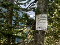
Interesting and unusual sign!
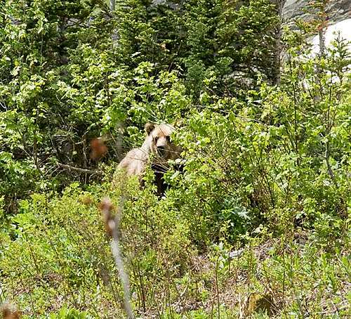
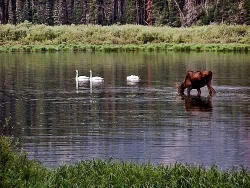
Probably anyone prone to climbing in this part of the country already knows this, but the Northern Rockies are full of wildlife, and considerations should be the same as for Glacier National Park. Always be aware, and don't do anything stupid, like—for example—leave food where bears can get at it, think that a mountain lion is even remotely related to your pet cat, or run up to a moose (moose are quite unpredictable, irritable, and very dangerous). And never, ever, EVER forget you’re in grizzly country; they insist on being left alone—disagreement on that point is not an argument you’ll win! Bear spray and noise should be part of every foray you make into the back country. Black bears will be found in the forests, grizzlies commonly venture onto the above-timberline tundra, sometimes, when in pursuit of such delicacies as ladybugs or cutworm moth larva, even to the summits (see McDonald Peak Grizzly Closure information above)! In addition to the wildlife already mentioned, the Missions are home to elk, Canadian lynx, bobcat, deer, wolves, the occasional grumpy wolverine (all wolverines are grumpy—it's a rule with them), badgers, martens, innumerable rodents large and small, both bald and golden eagles, osprey, and loons (over 50 different species of birds!), and flowers. And to top it all off, in the spring of 2005, a pair of trumpeter swans took up residence on the Mission's eastern flank, nesting on one of the Seeley-Swan Valley's many lakes. The female was killed when she flew into power lines, but the male raised the cygnets, and the fervent hope is that the family will return each summer—trumpeter swans are wonderful!
 |
 |
|---|
WHEN TO CLIMB
July, August, September. Late June (take your ice axe and crampons!) and early October may well be okay, but are iffy, and vary from year to year. The Missions get a lot of snow; don’t be mislead by the comparatively quick melt-off on the precipitous western front—the snow doesn’t stick to the steep slopes, and those western faces get a lot of sunlight. Just be aware: There’s a lot of snow in them thar hills, bucko....
CAMPING & LODGING
There is camping at the Twin Lakes Recreation Area. A Reservation Camping Permit is required, which may be purchased when/where you obtain the Hiking Permit, or may be purchased separately, at a later date. These permits are not site specific, and may be used anywhere in the Mission Mountains Tribal Wilderness (to repeat: one permit per year is all that is necessary, and each is $15.00). The sign at the entrance (see photo above) makes no mention of any length of stay restrictions. Any questions regarding the area? I've found the folks at the Cenex gas station in Saint Ignatius to have been very friendly and helpful in the past—I’d ask them. Also and lastly, the two closest communities to the trail head—Saint Ignatius and Arlee—have motels.
In Tribute
On March 1, 2011, Vernon Garner, Saintgrizzly, left us after losing a bold, inspiring fight against pancreatic cancer. Or maybe he won, for he is at last free of his pain and has "shuffle[d] off this mortal coil." Vernon was an important contributor on SummitPost, but beyond merely making good, informative pages, he actually inspired many who read his work. No one put more work into his or her pages than Vernon did, and many of those pages, especially those related to Glacier National Park, the place he loved above all others, are works of art in both the writing and layout. More than one person has wanted to visit Glacier or go back to Glacier largely due to what he shared about that magnificent place. Many people on SP counted Vernon among their friends, and many more saw him as one of the best, one of those who exemplified the spirit of this site. He was one of the best of us, he will be missed, and he will not be forgotten. As a tribute to him, Vernon's pages will remain in his name. Any member who sees a need for an addition or correction should please contact site management via the "Send PM to the Elves" feature. Rest well and climb on, Vernon.