
-
 18975 Hits
-
 88.19% Score
-
 26 Votes
|
|
Mountain/Rock |
|---|---|
|
|
46.17212°N / 11.59692°E |
|
|
Hiking, Mountaineering, Skiing |
|
|
Spring, Summer, Fall |
|
|
9341 ft / 2847 m |
|
|
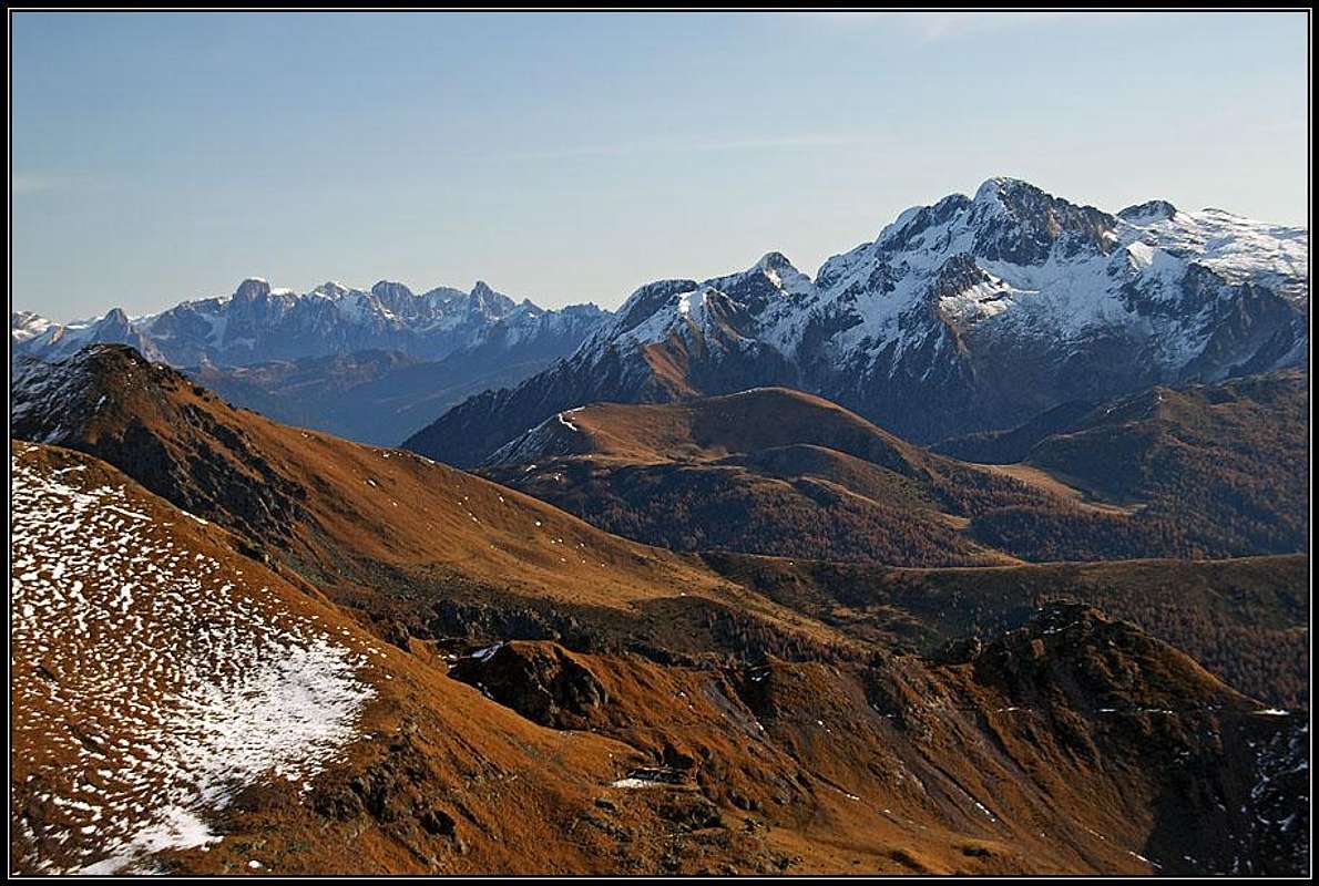
Overview
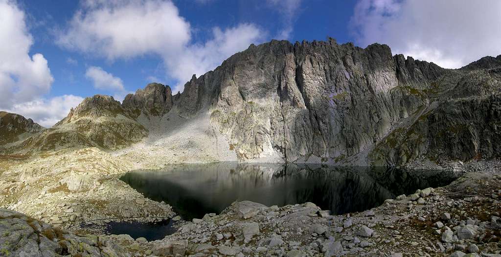
Cima d'Asta 2847 m
 South wall, lake and refuge
Cima d'Asta 2847 m is the main summit of the namesake massif situted in the Eastern part of Trentino region, in the middle of the most extended inhabited zone of the region. It is in fact a part of the wide Lagorai Group, a long chain West-East oriented that extends itself from Cima Panarotta to Passo Rolle for an approximately total lenght of 50 Km. It separates the Val di Fiemme (to the North) from the Valsugana valley (to the South). To the West the border is the Valle dei Mocheni, to the East the Passo Rolle.
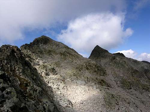
The Cima d'Asta massif occupies the Southern part of the Lagorai Group of which it constitutes a geographical subgroup (geologically different because made of granite and not of porphyr) and from which it is separated and at the same time joined by two valleys: the Val Campelle toward West and the Val Cia toward East. Normally the entire area is also called “Group of Lagorai-Cima d' Asta” in order to emphasize the geographic-territorial unit of the area inside which it is placed the Massif of Cima d'Asta. Moreover the massif is itself distinguished in the subgroups of Cima Tolvà and Cimon Rava and therefore some author prefers to consider it like an autonomous group. In every case from its main top, Cima d'Asta m. 2847, a 360° wide panorama is enjoyed.
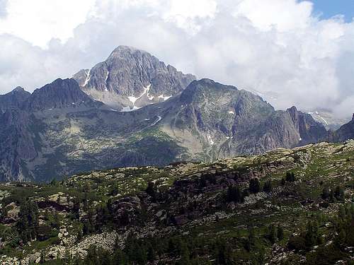
As mentioned Cima d'Asta is made up of granite rocks and this aspect distinguishes it from the nearby peaks of the Lagorai, consisting mainly of porphyries. From the point of view of rock climbing the extended South wall is particularly important, located in the immediate vicinity of the Rifugio Ottone Brentari. It's a beautiful granite wall rising directly from the lake.
Getting There
- By car from Trento: exit the A22 Brennero motorway to Trento Nord and follow the signposts Padova-Venezia, taking the SS 47 of the Valsugana. Continue on SS 47 of the Valsugana, pass Pergine and Borgo Valsugana, then follow the signposts to Strigno and Tesino. In Pieve Tesino follow the signposts "Malga Sorgazza" to the Val Malene valley.
- By car from Bassano del Grappa: take the state road SS 47 in Trento direction. At Grigno, exit and take to right to Castel Tesino. In Pieve Tesino follow the signposts "Malga Sorgazza" in the direction of the Val Malene.
- Nearest airports: in Verona Aeroporto Valerio Catullo; in Venezia Aeroporto Marco Polo; in Bolzano-Bozen Aeroporto di Bolzano.
Cima d'Asta Normal route
 Cima d'Asta from Lasteati
Cima d'Asta Normal route
Summit quote: 2847 m
Difficulty: EE
Difference in level: 1480 m
Exposition: SE
Starting point: Malga Sorgazza
A superb and wild environment. The ascent is long if carried out without staying overnight at the shelter, anyhow very advisable.
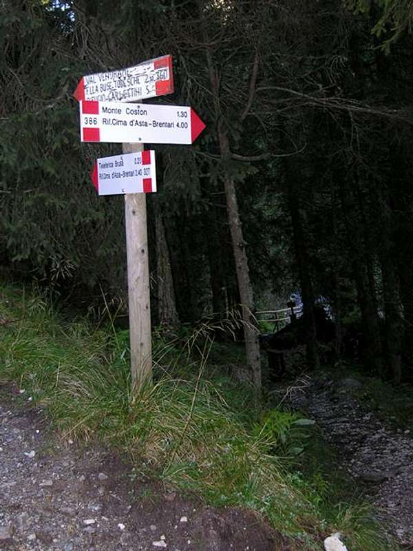
To the North of the village of Pieve Tesino it begins the asphalted road of the Val Malene that penetrates in the subgroup of Cima d'Asta. After 10 kilometers the roads rising along the valley leads to a large parking lot near Malga Sorgazza, at an altitude of about 1450 m.
- Approach to the Refuge Ottone Brentari
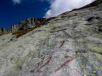
From Malga Sorgazza 1450 m take the forest road along the path SAT 327, leaving on the right the path SAT 386 and reaching the locality “Pont Brusà” 1647 m where it's situated the service cableway of the refuge Ottone Brentari. Here continue on the path SAT 327 rising with several bends along the valley called “bualòn” to an altitude of 2,000 meters where the path meets the path SAT 326 coming from Forcella Magna. Continue along the path SAT 327 until the remains of the old mountain hut "del Pastore" 2131 m. Here it is possible to choose if to continue along SAT 327 (steeper) or to walkon the variant SAT 327b (less steep). Choosing the SAT 327 it is necessary to gain the not dangerous but steep granite slabs rising directly to the lake of Cima d'Asta 2451 m that is situated beside the Refuge Ottone Brentari 2476 m. The variant SAT 327b makes a turn on the right in order to avoid the slabs, but the time does not change: 3,00 hours - difference in level 1040 meters.
 Viewing back to Val Malene Viewing back to Val Malene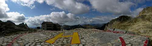 Ottone Brentari refuge Ottone Brentari refuge |
 Along path SAT 327 Along path SAT 327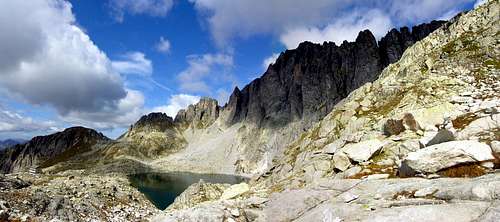 Leaving the refuge Leaving the refuge |
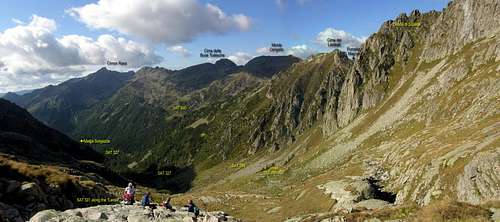
- Route description (East normal route)
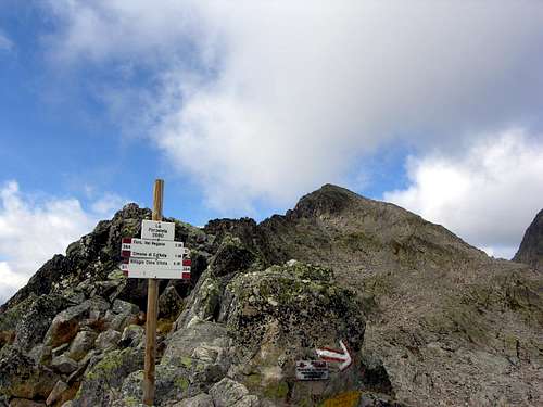
From the refuge follow the path SAT 364 skirting the small lake and rising to reach the deep saddle named “Forzeleta” 2680 m, situated along the East Ridge. From this saddle the path turns to NW (to the left going up) and then it comes down for 80-100 meters to get the "Conca Lastè dei Fiori" . Here ignore the path SAT 364 descending to the Vallon di Cima d' Asta. By a marked path, after leaving right and down the Passo dei Diavoli, continue along the slope getting the summit cross at 2847 m (from the shelter hours 1.15-1.30 - difference in level 375 meters+80 meters in reduction = 454 meters). Some meters to NW of the cross is found, lower, the Bivacco Giuseppe Cavinato 2840 m.
• Note: if the climb is done in a single day without staying at the shelter, the total difference of level from Malga Sorgazza to Cima d' Asta is approximately 1480 meters.
 At the "Forzeleta" saddle At the "Forzeleta" saddle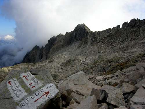 The Lastè dei Fiori The Lastè dei Fiori |
 From "Forzeleta" saddle toward the top From "Forzeleta" saddle toward the top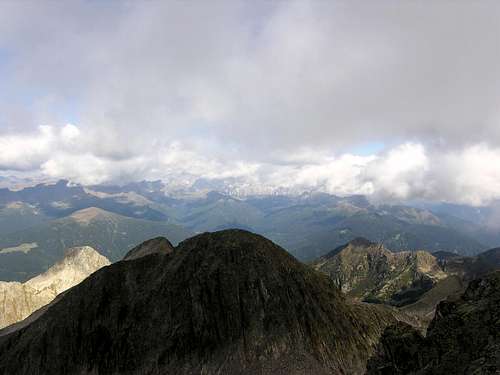 From the top toward Cima dei Diavoli From the top toward Cima dei Diavoli |
Italian version: A nord del paese di Pieve Tesino inizia la strada comunale asfaltata della Val Malene che si addentra nel sottogruppo di Cima d'Asta ed è solcata dal torrente Grigno. Dopo dieci chilometri si giunge alla località Malga Sorgazza (1450 m - aperta nel periodo estivo con servizio di ristorazione e parcheggio). Di qui inizia il percorso a piedi, che dividiamo in due parti:
• prima parte (Malga Sorgazza - Rifugio Ottone Brentari): da Malga Sorgazza m. 1.450, seguire la strada forestale lungo il sentiero sentiero SAT 327 fino alla località "pont Brusà" (m. 1.647) dove parte la teleferica di servizio al rifugio Brentari. Scegliere il sentiero SAT 327 che risale con numerose svolte il vallone chiamato localmente "bualòn" fino a quota 2.000 dove incontra il sentiero SAT 326 proveniente da Forcella Magna. Proseguire lungo il SAT 327 fino ai ruderi della Baita del Pastore (m. 2.131). Qui è possibile scegliere se proseguire lungo il sentiero SAT 327 (più ripido) oppure optare per la variante SAT 327b (meno ripida). Se si prosegue per il SAT 327 occorre vincere le placche in granito non pericolose ma ripide che portano direttamente al Lago di Cima d'Asta (m. 2451) e al vicino Rifugio Cima d'Asta - Ottone Brentari 2.476 m. La variante SAT 327b compie un giro sulla destra per aggirare le placche granitiche, ma il tempo non cambia: 3.00 ore, dislivello 1.040 metri.
• seconda parte (Rifugio Ottone Brentari - via normale dalla cresta est): dal Rifugio Brentari seguire il sentiero SAT 364 che aggira ad est il lago e sale fino a raggiungere la profonda sella ("Forzeleta", m. 2.680) incisa nella cresta orientale di Cima d'Asta. Dalla sella, il sentiero gira a NW (sinistra per chi sale) e scende per 80-100 meters fino alla conca sassosa dei Lastè dei Fiori. Si abbandona il sentiero SAT 364 che scende nel Vallon di Cima d'Asta e si prosegue lungo il pendio E della cima seguendo un percorso intuitivo e segnato che, lasciato a destra e in basso il Passo dei Diavoli, porta alla croce di vetta a m. 2.847 (dal rifugio ore 1.15-1.30, dislivello 375 meters+80 meters in discesa = 454 meters). Qualche metro a NW della croce si trova, leggermente più in basso, il Bivacco Giuseppe Cavinato 2840 m.
• Se il percorso viene compiuto in una sola giornata, il dislivello complessivo in salita Malga Sorgazza-Cima d'Asta è di 1.480 meters circa.
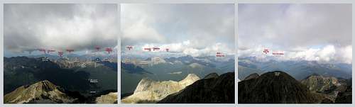 Pano toward north
Essential gear
Normal hiking equipment with warm clothing
Cima d'Asta Parete Sud
The extended South wall of Cima d'Asta is located in the immediate vicinity of the Refuge Ottone Brentari. It's a beautiful granite wall rising directly from the lake and reachable very quickly from the refuge. The South wall began to be explored in the Fifties; in fact the first climbing route was realized in 1952 by Ruggero Lenzi and Mario Michelini. Since then, the new routes realized on the wall have followed over time and now there are several ones, generally not too busy despite the beauty of the place and the rock probably due to the long approach from the valley floor.
In order to climb on the South wall, to stay overnight at the shelter is recommended. The length of the routes varies from 130 to 400 meters. We quote a selection of the routes (difficulty expressed in the UIAA scale):
Via del Dente VI+, 255 m - F. Melchiori 1986 / The day after V+, 225 m - F. Melchiori, F. Ognibene 1987 / Marco e Silvia V+, 185 m - F. Melchiori 1994 / Marietto V, 330 m - D. Lira, R. Bassi 1989 / Roger V, 400 m - D. Lira, F. Melchiori 1982 / Franco VI, 300 m - G. Bagattoli, J. Espen, G. Espen, F. Leoni, Paola Fanton 1987 / Via Melchiori - Pianta IV+, 300 m - G. Melchiori, O. Pianta 1959 / Brontolone VI, 420 m - M. Giovanazzi, P. Calzà 1993 / White out VI, 415 m - G. Tomio, P. Marconi 1994 / Dado VI, 300 m - M. Marchesini, T. Ellero 1980 / Nebbie d'autunno V, 200 m - G. Tomio, M. Piasente 1989 / Erminio Marchetto V+, 280 m - F. Melchiori, L. Vesco 1983 / Via dei Camini IV+, 280 m - G. Bernard, G. Burlini 1988 / Le donne del rifugio V+, 300 m / Lino Egidio IV, 300 m - F. Melchiori, F. Ognibene 1983 - A classic, the most suitable route for a first approach with climbing on Cima d'Asta / La testa del drago 6c max, 6a obbl., 130 m - F. Simonetto, G. Tomio, M. Piasente 1993 / Via dei cristalli V+, 245 m - Roberto Bassi, Dario Zampieri 1987
For more information we suggest the excellent guidebook "Lagorai Cima d'Asta - Climbing on the granite of the Dolomites". Reports and sketches are available also at the Rifugio Brentari.
Red Tape
No fees no permits required
When to climb
Climbing and hiking: the best period is during summer or early fall.
Sky-mountaineering: from March to April
Hut and bivouacs
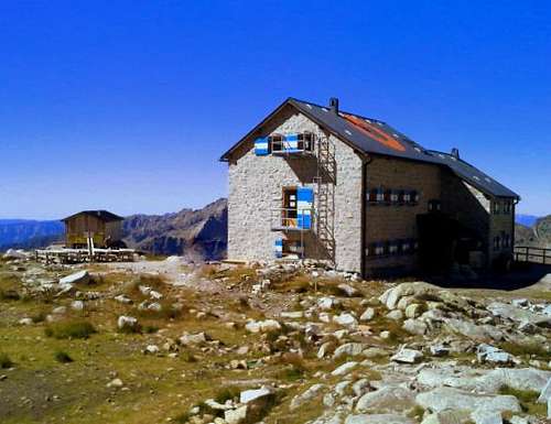 Refuge Ottone Brentari
- Rifugio Ottone Brentari - Normally open since June 20th to September 20th; in the other periods it is possible to take advantage of the winter room (6 places).
- Bivacco Giuseppe Cavinato 2840 m. - Two bed places with mattresses and covers. From its window the refuge Ottone Brentari can be seen.
Other accomodation
The Camping Val Malene is situated in the low Val Malene valley and works the entire year.
Malga Sorgazza is always opened with restaurant service. Here it is a large free parking area.
Miscellaneous
• The coming from Pieve Tesino road continues like dirt road also beyond the locality Malga Sorgazza, but its access with private motor vehicles is prohibited.
• After the refuge, to carry with himself one water bottle: for the first time during 2006 summer no snow remains in Lastè dei Fiori: a sign of the progressive withdrawal of the ice in the alpine arc.
Meteo
Guidebooks and Maps
- "Lagorai Cima d'Asta - Climbing on the granite of the Dolomites" by Alessio Comz, Gianfranco Tomio, Edizioni Versante Sud
- "Lagorai - Cima d'Asta" by Mario Corradini, Touring Editore, Milano 2006. A complete and exaustive guide to the paths into the most large wilderness-area of Trentino. Useful also for the climbers. Edited by Touring Club Italiano in collaboration with the official Club Alpino Italiano C.A.I.
- Carta Tabacco 058 - Valsugana Tesino
- Carta Kompass 626 (Catena dei Lagorai-Cima d'Asta) 1:25,000 or Kompass 621 (Valsugana-Tesino) 1:25,000
- Advised book: for extensive and detailed information on the Great War it is indispensable to refer to the historical work of Walther Schaumann: "La grande guerra 1915-18, Volume 3 - Prealpi Venete e Trentine", Ghedina & Tassotti Publisher Limited, Bassano del Grappa (Italia), 1984 (this is the italian version of the original “Schauplaetze des Gebirgskrieges - Oestliche Dolomiten, Sexten, Cortina di Ampezzo”. Colonel Walther Schaumann also has founded the association Friends of the Dolomites.