-
 16321 Hits
-
 78.27% Score
-
 9 Votes
|
|
Mountain/Rock |
|---|---|
|
|
37.12655°N / 118.53149°W |
|
|
Inyo |
|
|
Scrambling |
|
|
Summer |
|
|
13241 ft / 4036 m |
|
|
Overview
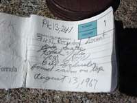
Gendarme Peak is an infrequently climbed peak located in the Inconsolable Range near Bishop Pass. The first recorded ascent was in 1967 by Andy Smatko and party, although the summit register mentions that they found a small cairn on the summit. The original summit register was still present as of August 2006 - apparently the peak was not "officially" named then, so the first page of the register lists the peak's name as simply "Peak 13,241'". Other sources indicate that the name was made official later, in 1969.As mentioned, the peak is climbed very infrequently, with the original summit register only about 1/2 full. During the 1970s-late 80s, there were several gaps of 5+ years with no signatures. Recently, the peak has become more popular, although nothing compared with other nearby peaks like Agassiz that are climbed daily.
There are four gendarmes/towers immediately to the east of the summit block. Three of the gendarmes are no harder than easy cl.3, while the fourth may be a bit more difficult (I did not climb all four when I was there). Two of the gendarmes look to be within a few feet elevation difference of the summit block proper, but none of them are the actual high point. The scrambling is fun on the gendarmes, but not significantly long or sustained.
There are excellent views of the Inconsolable Range peaks like Picture Puzzle, Cloudripper, and Aperture Peak. Further south, the view of the Palisades are also great.
 Summit register | 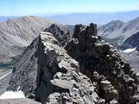 The gendarmes | 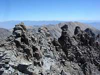 The gendarmes |
Getting There
Although the peak might be able to be climbed from the north side (from the vicinity of Cloudripper from Seventh Lake), the slope is steeper on that side and there is a permanent snowfield that may impede progress. There are at least two obvious easier approaches:1) From N. Fk. Big Pine Ck. Tr., hike to Fifth Lake and then follow the drainage up to the S. slopes of Gendarme. You'll encounter sand and boulders most of the way from Fifth Lake, with no significant challenges during the ascent. Class 2.
2) From the vicinity of Bishop Pass, hike to Jigsaw pass and then follow the obvious ridge or S. slopes to the summit. This description, although accurate, does not do justice to the routefinding required to locate Jigsaw pass to begin with. See the next section. Easy Class 3.
* Note *
There is a trail named 32E06 on the USGS topo map, marked "Location Approximate". This trail starts at the moraine just below Bishop Pass and goes to Fifth Lake, or so the USFS would like you to think. I never found a trail, and did not see any "trail-like" constructions on the way, so I doubt it even exists anymore. The 1968 edition of "Sierra South" mentions that the trail was "beautifully built, but now landslide covered". Considering that the above description was written over 40 years ago, it's not a surprise that it's almost completely gone now.
Jigsaw Pass Approach
Jigsaw pass is difficult to identify from the Bishop pass trail. The crest of the ridge to the east looks extremely steep, and there are many notches that look more like passes than Jigsaw Pass does. When climbing up, I made the mistake of going too far to the north, and ended up crossing the ridge at some other "pass", a crappy loose rock/sand adventure that I don't want to repeat.From the Bishop Pass trail, near where the trail crosses the last creek but before the trail starts switchbacking through the moraine, head east, cross country through the moraine toward the correct chute, described below. Travel through the moraine is through large boulders, but only class 2. It's pretty easy terrain, so if you leave the trail a little too early or too late, you're unlikely to encounter any major problems finding the correct route using the images below.
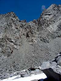
To identify the chute leading to the correct Jigsaw Pass, look at the images below and zoom in- you'll see a 4x4 wood post that was sticking up out of the top of one of the chutes when the image was taken in 2006. As of September, 2010, it was reported that this post is no longer there, but apparently has been replaced as of September 2014 (as one climber reports). Aim for THIS chute - this is Jigsaw pass. It's important to note that the pass is NOT at the low point in the saddle to your east, but rather to the south side. A small pair of binoculars might help locating the post. Although steep, the climb to the pass is not harder than easy class 3. Once you make it to the top, the east side of the pass is a gentle bowl, much easier than the west side.
At the top of the pass, there is a pass register. I was the first one to sign the pass register in the previous 2 years. If you ascend to Jigsaw Pass, make sure you take notice of where the pass actually is for the return trip - it's up on the shoulder of Aperture peak, and not the lowest point in the saddle.
 Jigsaw Pass From Below | 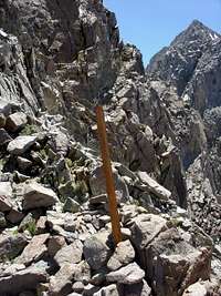 Jigsaw Pass | 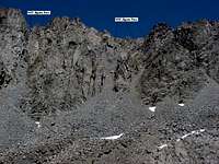 Incorrect chutes | 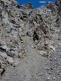 Correct Jigsaw Pass chute |
The climb up to the pass (or down from the pass) covers some loose sandy slabs with plentiful loose rock. If you are ascending/descending solo, you'll probably be fine. If there is anyone above or below you in the chute, make sure you prepare for falling debris - it would be tough to go through the entire chute without dislodging something. The chute is narrow; it would be difficult to spread out, so it might be "single file" for groups ascending or descending.
Identifying Jigsaw Pass from the east side should pose no major issues. If your original ascent was from the west, just make a mental note of where the pass is when you exit the chute at the top of the ridge. If you are starting from Fifth Lake and are attempting to exit via the Bishop Pass trail, Jigsaw Pass is about 500-600' south of the low point in the saddle. It is located higher on on the shoulder of Aperture peak than you might think. Look for the pass register and you'll be fine (although it was much easier when the post was still there!)