
-
 37000 Hits
-
 98.76% Score
-
 89 Votes
|
|
Mountain/Rock |
|---|---|
|
|
41.63586°N / 112.01373°W |
|
|
Box Elder / Cache |
|
|
Hiking, Mountaineering |
|
|
Spring, Summer, Fall, Winter |
|
|
9372 ft / 2857 m |
|
|
Overview
 Box Elder Peak
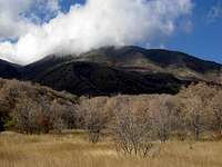
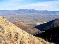
Box Elder Peak is the highest summit in the Wellsville Mountains of Northern Utah. The Wellsville Mountains are a subrange of the Wasatch Range. They have been called the steepest mountain range in the country. This is because they are the highest mountains to rise from such a small base. The range is very rugged, compact, and narrow. The mountains are over 4,500 feet above the valley and have few foothills. The range is approximately 14 miles long and 4 miles wide. It runs in a north to south direction with many side canyons on the west and east.
The Wellsville Mountains are made out of limestone which is typical of all mountains in Cache Valley. The second highest mountain in the range is Wellsville Cone which is 9,356 feet tall. It is only sixteen feet lower than Box Elder Peak and located on the ridge to the north. Other mountains include Mendon Peak, Scout Peak, and Pleasant View Point on the north end of the range. On the south end of the range are Mitton Peak and Black Peak and several unnamed points. The view from the summit of Box Elder Peak is very good and includes Cache Valley, the Bear River Range to the northeast, and the main ridge of the Northern Wasatch Mountains.
Peak 8,626 is known as Bob Stewart Peak. His family was one of the earliest settlers in thea area. He was employed by the U.S. Forest Service as an adviser. Thanks to his efforts, the Wellsville Mountains would have never became a wilderness area. He started a nonprofit group that purchased much of the overgrazed land in the area.
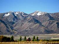
In September 1856, Peter Maughan was sent to settle in Cache Valley. He built Maughan's Fort when he arrived with the first settlers. The fort grew into a town and its name was later changed to Wellsville after Daniel H. Wells. The mountain range would also be named after him. He was a pioneer settler, second counselor to Brigham Young, and a former commander of the Nauvoo Legion. The city of Wellsville is Cache County's oldest permanent settlement. It occupies the southwest corner of the valley. The small town of Mendon is located nort Wellsville. The city of Honeyville is below the west side.
The Wellsville Mountains Wilderness was established by Congress in 1984. It occupies an area of 23,850 acres and is located entirely in Utah. The water that runs out of the Wellsvilles helps supply many cities. The wilderness was once overgrazed but has recovered and now has populations of deer, elk, moose, and mountain lions. Day hikers, hunters, and bird watchers use the area the most but it is never crowded. There are about 17 miles of trails to explore. For those of you who are interested in climbing prominence peaks, Box Elder Peak has the 27th highest prominence in Utah. It is included with several other peaks with over 2,000 feet of prominence in the state. There are two Box Elder Peaks in Utah, the other one is located south of Lone Peak in the Central Wasatch. There seem to be no other mountains named Box Elder Peak in the rest of the United States.
Getting There
 Sardine Canyon
Rattlesnake Trailhead: Drive on 1-15 and take exit 362 (east) onto US 89/91 towards Logan. In about ten miles you will go over Sardine Pass in Sardine Canyon. The southernmost trailhead, the Rattlesnake Trail, will be four miles further, on your left as the road makes a sweeping right curve. You will have to keep driving to circumvent the cement highway divider. If you are coming from Logan, you won't have to worry about this. Once out of Sardine Canyon, turn around and drive back into the canyon to the trailhead. Park at the pullout on the side of the road next to a gate.
Coldwater Canyon Trailhead: Drive on 1-15 and take exit 362 (east) onto US 89/91 towards Logan. Drive through Sardine Canyon and continue driving. Turn left off of US 89/91 and then onto UT 23 towards Wellsville. This will lead you straight through town. Continue into the town of Mendon. Find the corner of Center and Main Street. Then drive south on Main Street. After 0.5 mile the road crosses the highway.
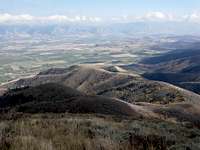
 Wellsville Mountains
Drive another 200 yards until you see a sign on the right that says National Forest. This sign may be a little hard to see because of vegetation. Turn right onto this gravel road which starts out in good condition. It is 3.4 miles from the junction to the trailhead. As you drive farther there will be deep ruts in the road. You will have to slowly drive over these. A high clearance vehicle is recommended especially if the road is wet.
Deep Canyon Trailhead: Drive on 1-15 and take exit 362 (east) onto US 89/91 towards Logan. Drive through Sardine Canyon and continue driving. Turn left off of US 89/91 and then onto UT 23 towards Wellsville. This will lead you straight through town. Continue into the town of Mendon. Find the corner of Center and Main Street. Then drive north on Main Street to 300 North. Continue up this road as it turns into dirt for 2 miles. The trailhead is located at the end of the road.
 Pine Canyon
Pine Canyon Trailhead: To get there Drive on 1-15 and take exit 362 (east) onto US 89/91 towards Logan. Drive through Sardine Canyon and continue driving. Turn left off of US 89/91 and then onto UT 23 towards Wellsville. This will lead you straight through town. Follow this to 500 North, which is also Pine Canyon Road and turn left. Continue straight toward the drainage in front of you, which happens to be Pine Canyon. More than likely, you will come across a closed gate at this point and will have to park off to the side and start walking from there. This is a good route for climbing Box Elder Peak in winter. The elevation gain will be around 4,450 feet.
West Side Trailheads: This side of the Wellsville Mountains is very rugged and steep. It probably has the most difficult routes up these peaks but there is some private land near Honeyville on the west side of the range. It is recommended that you don't climb any of the routes on this side of the range. This is not really a problem because there are many routes on the east side of the range.
Routes Overview
The following routes are listed from south to north. The Rattlesnake trailhead is located on the west side of Sardine Canyon near the road. The Coldwater Canyon trailhead is located above the city of Mendon. The Deep Canyon trailhead is located at the north end of Mendon.
Rattlesnake Trail The Rattlesnake Trail is the most direct route to Box Elder Peak and has become the standard route to the summit. The trailhead is located on the road going through Sardine Canyon and can be reached by any vehicle. It starts out on an dirt jeep track. At a sharp switchback the trail branches off and starts climbing up the canyon. There are many switchbacks as it goes up the ridge. It eventually ends up near a saddle southeast of Box Elder Peak. Then the route goes up toward the ridge. The trail is a little overgrown is some places but is in fairly good condition. There are a few places where the right path may not be obvious. It is 4.5 miles from the trailhead to the summit. The route page describes it in more detail.
 Rattlesnake Trail Rattlesnake Trail |
 Rattlesnake Trail Rattlesnake Trail |
 Box Elder Peak Summit Box Elder Peak Summit |
 Wellsville Cone Wellsville Cone |
|---|
Coldwater Canyon Coldwater Canyon is a steep route but has the least amount of elevation gain. In the first mile you will pass Coldwater Lake. This is the only lake in the whole range. Actually, it is more like a small pond. There are several side trails in this area so just stay on the main trail after the lake. The trail traverses along the mountainside and then ascends rapidly and steadily for over 3 miles as it climbs up towards the ridge. From here you will have great views of Cache Valley below. The trail is in good condition and easy to follow. It tops out at Stewart Pass. From the pass you should go left. It is a 1.6 mile hike along the ridge to Wellsville Cone. The mountain resembles a cinder cone on its north side. The route drops down west and then climbs back up south for 0.9 miles to Box Elder Peak. The summit consisted of a pile of boulders. The distance is 5.7 miles from Coldwater Canyon trailhead to the summit.
 Coldwater Lake Coldwater Lake |
 Coldwater Canyon Coldwater Canyon |
 Coldwater Canyon Coldwater Canyon |
 Box Elder & Wellsville Cone Box Elder & Wellsville Cone |
|---|
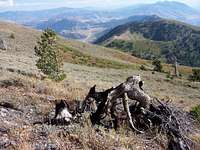
Deep Canyon Deep Canyon is the longest route to Box Elder Peak. The trail is easy to follow as it goes through the canyon. The vegetation will be over your head for much of the way. There is stinging nettle and other plants that may be unpleasant to some people. It takes 3 miles of uphill climbing just to get to the ridge overlooking the canyon. From a saddle at the top of the ridge, there is a side trail that goes north to point 8,585. This is a viewpoint that is used by bird watchers. The regular trail continues towards Stewart Pass. You'll have an opportunity to climb over other points along the way. They include Mendon Peak, Scout Peak, and Pleasant View Point. The trail continues to Wellsville Cone and then Box Elder Peak. Distance is 7.4 miles from Deep Canyon trailhead to the summit.
When to Climb
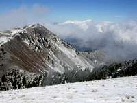
 Box Elder Peak view
Box Elder Peak hiking season is from June to October. Summer temps can range between 75 to 85 degrees in the daytime to 30 degrees at night. In Wellsville, the average temperature is 86.9 degrees in summer. There may be a lot of mosquitoes so bring bug spray. May is the best time for spring snow climbs. Another good time to visit is in autumn when the colors are changing. This last from mid-September to early October. Sardine Canyon is very colorful during this time. This area can get very cold in winter. The average low temperature in January is 13.7 degrees. This is colder than other areas in the Wasatch. Weather Forecast for the cities of Wellsville and Mendon and the Wellsville Mountains
Camping
 Box Elder Peak
 Wellsville Cone
There are no campgrounds near the Wellsville Mountains. There are plenty of primitive places to camp and backcountry camping is allowed. The Coldwater Canyon trailhead has a few sites. Coldwater Lake is a good place to camp. Backcountry Camping Regulations: Camp at least 200 feet away from lakes, trails, or other sources of water Camp for a period of 3 days or less at an individual site Practice leave no trace techniques
Red Tape
 Wellsville Mountains
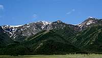 Wellsville Mountains in Spring
The Wellsville Mountains are located in Wasatch-Cache National Forest There are no fees for hiking in these mountains. The following rules apply: Group size of 10 people or less No short-cutting any trail switchbacks No disposing of garbage, debris, or other waste.
Bird Watching
 Wellsville Mountains
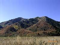
 Coldwater Canyon & Scout Peak
The Wellsville Mountains are well known to bird watchers. From late August until late October each year, Hawkwatch International puts observers on the top of the Wellsville Mountains to count the thousands of raptors that migrate along this narrow ridge taking advantage of the updrafts created by a prevailing west wind. The wind on top of these mountain ridges can be very strong. The Wellsville Mountains have wide open views of the surrounding valleys. Raptors use this mountain range as a major flyway. Hawk migration is the best after a cold front from a storm passes through the area. Most western hawk species can be seen from these mountains. Other birds include golden eagles and peregrine falcons. This is one of the oldest hawk watching sites in the Western United States.
Books
Utah Mountaineering Guide By Michael R. Kelsey. The green book describes Deep Canyon and Coldwater Canyon but doesn't talk much about the Rattlesnake Trail. There are four pages in the book about the Wellsville Mountains. It has a map and a few photos. Utah's Favorite Hiking Trails By David Day. A great hiking book. It has a good description and map of the Deep Canyon to Coldwater Canyon hike.
External Links
Deep Canyon to Coldwater Canyon Hike This is an excerpt for this hike from the book Utah's Favorite Hiking Trails for those of you that do not have the book. Utah's 100 Most Prominent Peaks List Submitted by redsplashman23. Box Elder Peak has the 27th highest prominence in Utah. This is a list the most prominent peaks in the state.