
|
|
Mountain/Rock |
|---|---|
|
|
36.01000°N / 118.391°W |
|
|
Tulare |
|
|
Hiking, Scrambling |
|
|
Spring, Summer, Fall |
|
|
9909 ft / 3020 m |
|
|
Overview
Sherman Peak, elevation 9,909 feet, is on the eastern side of Sequoia National Forest on the edge of the Kern Plateau. It affords tremendous 360 degree views of the Great Western Divide, the Sierra Crest including Mt. Whitney, Langley, and Olancha, and a bird's eye view of the Kern River Canyon and Little Kern River drainage. It is no wonder it was once the site of a fire lookout, but today only a few radio transmitters are on the top.
The trail to Sherman Peak is 2.5 miles long (5 miles round trip) and climbs about 700 feet. Most of the elevation gain is at the end but the trail switchbacks so it's not too steep. Along the way you'll pass through a beautiful red fir and western white pine forest. There are many interesting rock piles along the way that make for some fun scrambling as well. This trail is suitable for hikers, horses, and adventurous mountain bikers. It is not open to motorcycles.
Link to live webcams mounted on various southern Sierra peaks, 6 are on Sherman Peak!
Getting There
The trailhead for the Sherman Peak Trail (Trail 33E35) is at the Sherman Pass Vista Point. This Vista Point is at Sherman Pass, the highest point of the Sherman Pass Road (a.k.a. County Road J-41 or Forest Service Road 22S05). Here you will find a large paved parking area, an interpretive sign, and most of the year there is a pit toilet here for your use. From the vista point walk south on the road for about a hundred feet and you will see the sign for the trail on the west side of the road.
From the east: Take Nine Mile Canyon Road from Hwy 395 near Pearsonville. Head west up to Kennedy Meadows then turn left on the Sherman Pass Road and head on to Blackrock and eventually Sherman Pass.
From the south: From Kernville take County Road M-99 (Sierra Way) north towards Johnsondale. Just before crossing the bridge and heading the last few miles up to J'dale, turn right on the Sherman Pass Road. Follow it up all the way to Sherman Pass.
From the west: Take County Road M-56 from Ducor east up to California Hot Springs. In CA Hot Springs continue east on County Road M-50 (Parker Pass). Once you're over the pass continue down to Johnsondale. Continue past J'dale and descend to the Kern River. Just after you cross the bridge turn left on the Sherman Pass Road.
If you've got a 4wd vehicle there is an old jeep road going up to Sherman Peak (Forest Service Road 33E48). It affords access to the people that maintain the radio towers on the top. I haven't driven the road so don't know what condition it is currently in. It looks to be really steep so best to check with the Ranger Station in Kernville before attempting it (see contact info below). Look for the beginning of this road in a large turnout west of Sherman Pass about 8 miles.
The Sherman Pass Road is typically open late May/early June through mid-to-late November. This year it remained open later in the year due to warmer than usual weather conditions.
Sequoia National Forest Map based on Durrwood Creek Quad showing Sherman Peak
Other Sequoia National Forest Quad Maps
Buy a Sequoia National Forest Map
Red Tape
No permits are needed to hike to Sherman Peak. If you wish to disperse camp in the area and have a campfire you will need a campfire permit, which is available free of charge from any Forest Service, California Department of Forestry (CDF), or Bureau of Land Management (BLM) Office.
Please practice Leave No Trace ethics!
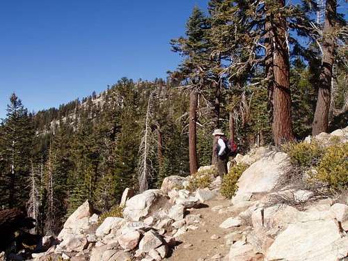
Hiking along the Sherman Peak Trail with our goal now in sight!
Camping
There are four campgrounds not too far of a drive from Sherman Peak. They are Horse Creek to the south off the Cherry Hill Road and Troy Meadows, Fish Creek, and Kennedy Meadows to the east along the Sherman Pass Road. I have not stayed at any of them but have heard good things about Horse Creek and Kennedy Meadows. Troy Meadows and Fish Creek are popular with off-roaders. For more information visit this website!
You can also disperse camp in most areas of the Forest. Find a Forest Service dirt road that looks interesting, drive down it, and chances are you'll find a pullout where it looks like people have camped before. Remember to bring your own water, pack out what you pack in, and obtain a campfire permit (see red tape section).
External Links
Sequoia National Forest
Sequoia National Forest Fire Lookouts
Tulare County Mountains Weather Forecast
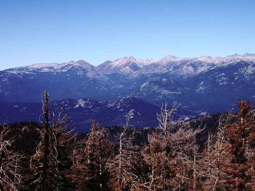
Farewell Gap and the Great Western Divide as seen from Sherman Peak
For more info, please contact
Kern River Ranger District - Kernville Office
105 Whitney Road
P.O. Box 9
Kernville, CA 93238
760-376-3781