|
|
Mountain/Rock |
|---|---|
|
|
43.55940°N / 121.8114°W |
|
|
Klamath |
|
|
Hiking |
|
|
Spring, Summer, Fall, Winter |
|
|
7098 ft / 2163 m |
|
|
Overview
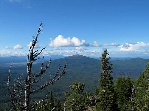
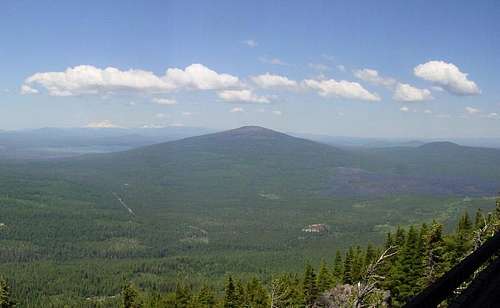
Hamner Butte is another central Oregon peak that has the name Butte in it and is the remnant of an ancient volcano. How ancient I don't know but I thought that sounded good. Hamner Butte is one of many of the buttes or peaks in this area that give solid evidence to the volcanic activity that once dominated in this part of Oregon. No matter which way you turn, volcanic activity is evident. A nearby neighbor is Odell Butte and is a close neighbor to Davis Mtn (6624 ft), which is just north of Hamner.Hamner Butte is another one that isn't any kind of a technical challenge but it is important as one of Oregon's 73 prominence peaks. It ranks #38 with 2338 of prominence and although the linked list shows 75 prominence peaks, only 73 of the peaks on the list have the required 2000 feet of prominence.. The interesting thing is with Odell Butte nearby and Maiden Peak, Hamner Butte makes it a triangle of three prominence peaks all in the same area. One of the few places in Oregon that has this set up but for a peakbagger, it is possible with the long days of June to do all three peaks on the same day. Want even more in one day? Add Paulina Peak, a drive up once the road to the top.
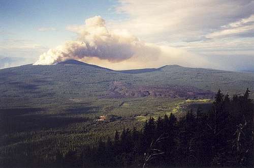
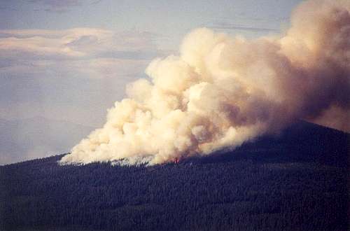
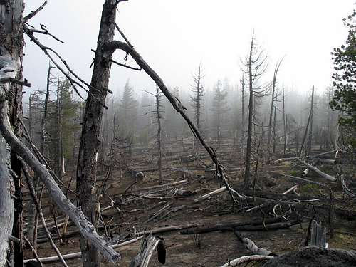
Hamner Butte had a controlled fire set in June of 2003 which resulted in the burning of the forest at the top of the peak. The fire spread to nearby Davis Lake area and ruined much of the forest in and around the lake and two of the campgrounds located there. I am hopeful to find out more information on the purpose of the fire but Paul Klenke captured it well in the below photo.
Hamner Butte is another Oregon prominence peak and that is perhaps the main reason why people would take the time to climb to its top. It ranks #38 on this list and has 2338 feet of prominence.
Getting There
Hamner Butte is accessed from Hwy 46 the Cascade Lakes Highway. This highway is closed during the winter because of snow. There are several ways to drive to this area. Hwy 46 starts near Bend and Hamner Butte is a long drive up a beautiful highway. The turn-off for Hamner Butte is only about a mile before it ends.However, since I was interested in both Odell Butte and Hamner Butte, I went this route:
I headed south from Bend and LaPine to a small town called Crescent. In Crescent, look for highway 61, also known as the Crescent Cutoff Road. Go about 9 miles, passing the Crescent Creek Campground (on the south side) and watch for highway 46 and turn north. I'll provide more detail for where to turn to get to Hamner Butte in the route section. The turnoff is just up highway 46.
From I-5, take exit 188 onto Highway 58 and head for Oakridge. You will pass over Willamette Pass and continue past Odell Lake and then the small wide spot in the road known as Crescent Lake Junction. Watch for county road 61 after you pass through Crescent Lake Junction (maybe a mile or so) and turn onto #61 (aka Crescent cut off road). It is three miles to the turn off to Highway 46. If you pass the Crescent Creek campground, you have gone too far.
About a mile north of where you turn off from county road 61, watch for FR 4680 and turn right. That road is normally open but it just happened to be blocked by some road work the day I was there so I went another mile or two north and accessed the mountain via FR 4674 which is the road my route description is based on. I have FR 4674 GPS'd for you in the route description so if you have a GPS, pre set the coordinate for that road and you'll not drive past it. See the A route description for the rest of the information that will help you get to the top of this not so imposing mountain. Its at the left side of this page. Also be aware that some of the trees that burned in the fire years ago are still falling. Don't let a widowmaker take you out.
See the recent post in the climbers log by Paul McClellan for the driving directions he found that worked for him.
The aftermath of the fire. This is what the summit area looks like now
Red Tape
There is no red tape or forest pass needed to hike to the top of this peak.For more information:
Deschutes National Forest
1001 SW Emkay Drive
Bend, OR 97702
(541) 383-5300

Summit benchmark

Camping
There are several campgrounds in the area that provide reasonable camping facilities. Three in the immediate area are:Crescent Creek CG - 10 sites Vault toilets $8 (May- late Oct)
East Davis CG - 33 sites $8 Vault toilets (May-late Oct)
Lava Flow CG - 12 sites no fee (Sept-Dec) Check with ranger district
The fire that swept through the area a few years back also blackened alot of the area around East Davis Lake CG and I found many available spaces to use when I was there in 2005. The fire that swept through the area wasn't really intended to be part of the "controlled" fire and it has left the area as very unsightly. However, the campground is still functional and served my needs nicely for getting a good nights sleep. There were only about three other campsites used the night I was there.
Also, near the junction where you turn north from the road that connects you to both Highway 58 and Crescent Oregon is a small campground, the Crescent Creek campground which could serve as a base for both Odell Butte and Hamner Butte.
Bend Area Campgrounds (A list of them)
Big River, Bull Bend, China Hat, Cow Meadow, Crane Prairie, Cultus Corral Horse Camp, Cultus Lake, Deschutes Bridge, East Davis, Elk Lake, Fall River, Gull Point, La Pine State Recreation Area, Lave Flow, Lava Lake, Little Cultus, Little Fawn, Little Lave Lake, Mallard Marsh, Newberry National Volcanic Monument (Chief Paulina Horse, Cinder Hill, East Lake, Hot Springs, Little Crater, McKay Crossing, Paulina Lake, and Prairie), North Davis Creek, North Twin, Point, Pringle Falls, Quinn Meadow Horse Camp, Quinn River, Reservoir, Rock Creek, Rosland, Sand Spring, Sheep Bridge, Soda Creek, South, South Twin, Swamp Wells Horse Camp, Tumalo State Park, West Davis, West South Twin, and Wickiup Butte.
Or you can car camp near where you take off for the summit. Lots of choices.
Weather

Geologic background (under development)

Hamner Butte is a shield volcano and Wikipedia has a nice description.
There is more information on Hamner Butte forthcoming and I should have all of the information in place by the end of Dec 28th. including a route description as mentioned above.
In the Odell Butte information, some information is included about the volcanic aspect of the area. Please see that SP page for that information
if you should be interested.
Map

Central Oregon P2K's
Butte?
Oregon has a lot of mountains called Buttes in the state and this is another that is named a "butte". I was curious about the origin and exact meaning of the word "Butte" so I went to google and googled it. Here's what Wikipedia had to say:A butte is an isolated hill with steep sides and a small flat top, smaller than mesas and plateaus. Buttes are prevalent in the western United States and on the Hawaiian Islands, especially around Honolulu. The word "butte" comes from a French word meaning "small hill".
"Buttes are formed by erosion when a cap of hard rock, usually of volcanic origin, covers a layer of softer rock that is easily worn away. This hard rock avoids erosion while the rock around it wears down. One example of a noted butte is Chimney Rock."
The encyclopedia Brittanica had this similar explanation:
"(French: “hillock” or “rising ground”) Flat-topped hill surrounded by a steep cliff, from the bottom of which a slope descends to the plain. The term is sometimes used for an elevation higher than a hill but not high enough to be a mountain. Buttes topped by horizontal platforms of hard rock are characteristic of the arid plateau region of the western U.S. A butte is similar to a mesa but generally smaller; both are created by erosional processes."
One more pic of the fire
Thanks to Paul Klenke for his timely picture taking.