
|
|
Mountain/Rock |
|---|---|
|
|
43.84540°N / 71.4722°W |
|
|
Sport Climbing |
|
|
Summer |
|
|
2630 ft / 802 m |
|
|
Overview
Mount Israel located in the Waterville Valley-Sandwich Range near the border of the Lakes Region of New Hampshire is one of those special mountains that afford good view with moderate effort. This mountain can be climb at all times of the season. Unfortunately I could not enjoy this mountain to its true degree due to the fact that I was suffering a severe migrane attack and was with a group that was not very well prepared for the attack I was going through. However, I do remember a fair amount worthy of sharing.
The route to the summit, the Wentworth Trail (YDS class 1) goes through an old scout camp and then up past a creek with small waterfalls about a mile up. At one and a half miles from the starting point it hits the first of a number of nice viewpoints. Once it reaches the top at 2.1 miles a good view of the southern White Mountains.
The views are quite visible at the different stopping points on the way up to the top. The nice thing to me visually about it was the windy path to the top and in many cases, the twigs looked lined up in nice formation like a windy stairwell leading to the upstairs, except here we are talking mountain paths. So, it had some beautiful and striking views after each so called "stairwell" and then at the different stopping points, the mountain streams trickling down were beautiful and stunning and at many points, the trickling sound of the water down the "stairwells" or the many deep drops I am speaking off was very tranquil.
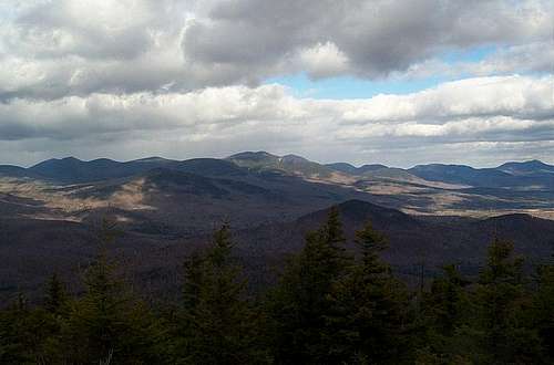 View from the summit north.
This mountain this such a small mountain and can be done easily in a day. Because it is moderately popular I personally would not camp there. However I did not see any signs when I was there forbidding it, so it looked like camping was a possibility. At the bottom of the trail, it should be noted also that there is a hiking building (which was closed at the time I was there) which must be manned during the busier times of the year as it seemed fairly well kept up, I but I had no sources to confirm that. However, it is my suspicion that during the busier months, there are more hiking resources with a possible brochure stop and maybe someone there to answer questions.
The bottom also contained some bathrooms for men and women to cater to the busier population during the summer months. The best part of the trail is when you can start to see both Lake Winnipeasaukee and Squam Lake. Additionally, the trail has a good view facing north as you start to go up and when it turns right at a ledge viewing area.
There are also plenty of cairns that those who placed them made careful measure to mark the trail so there is no chance on getting lost on the way up to the summit. At the time of my hike in the fall, it is known for being muddy and the leaves are quite slippery, even with the best of hiking boots as my companion had on at the time. So, I strongly suggest noting that weather change on this trail and the falling leaves that descend right after October when you are walking it and just make the point to go slower than usual. Otherwise, you will most certainly find yourself with a muddy behind. Also, when crossing the streams, you will come across several rocks that are also slippery but you will enjoy the view in the crossing.
This is truly a wonderful hike for families, a wonderful hike for solo hikers, especially beginning women hikers who may be a litter more weary or cautious or scared on larger trails. This is a great hike to start out and build confidence. The reason why it is a great hike for families and beginners of all ages is that the difficulty increases only gradually, and the views are beautiful and substantial, so one has time to really savor the view on the way up. I was able to get some great shots on the top and for a fairly small mountain the views of the Lakes Region on this mountain cannot be beat.
There is another route to the top, The Mead Trail which start 5.7 miles north from the town of Center Sandwich via the Sandwich Notch Road. The Mead Trail can be picked up by way of the Guinea Pond Trail. From the information that I have gathered this trip looks to be 3.3 miles one or 6.6 miles roundtrip. This route is much longer than the Wentworth Trail.
Getting There
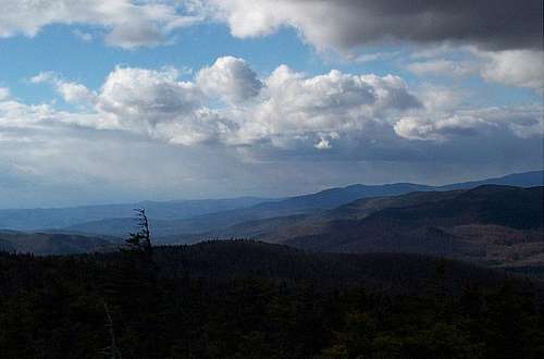 View towards the west.
Here are the directions from Exit 24 off of I-93. When getting off Exit 24 head east into the town of Ashland. Head through Ashland and then veer left toward Holderness once you go through the small village. Once in Holdnerness turn left onto Route 113 just before reaching the mouth of Squam Lake. Take 113 for roughly twenty minutes and stay on the road until just before Center Sandwich. Make a left on Sandwich Notch Road. The Wentworth Trail is located off of the Sandwich Notch Road about two and a half miles or almost ten minutes from Center Sandwich. The Guinea Pond Trail (Mead Trail) is located a little over three miles up the Sandwich Notch Road from the Wentworth Trailhead (5.7 miles from Center Sandwich).
Red Tape
 Mt. Chocorua
From what I remember there was no toll yet on this trail.
Camping
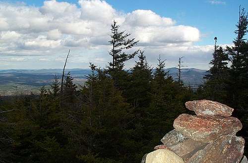 The summit cairn of Mount Isreal
This mountain this such a small mountain and can be done easily in a day. Because it is moderately popular I personally would not camp there. However I did not see any signs when I was there forbidding it, so it looked like camping was a possibility.
If you wish to camp on Mount Israel, you must follow White Mountain Backcountry camping rules which state that a)you are quarter mile or more from any road or building, b) be 200 feet or further from a water source or a trail and c) be below timberline. For more information on backcountry camping click on this website which states official backcountry rules.
At the bottom of the trail, it should be noted also that there is a hiking building (which was closed at the time I was there) which must be manned during the busier times of the year as it seemed fairly well kept up, I but I had no sources to confirm that. However, it is my suspicion that during the busier months, there are more hiking resources with a possible brochure stop and maybe someone there to answer questions. The bottom also contained some bathrooms for men and women to cater to the busier population during the summer months.
Weather Links
 alt="Click for Sandwich, New Hampshire Forecast" height=60 width=468>
Updated Hiking Links of the Area
Check out The Appalachian Mountain Club website and www.viewsfromthetop.com for up to date conditions.