
-
 12861 Hits
-
 85.87% Score
-
 21 Votes
|
|
Mountain/Rock |
|---|---|
|
|
30.63850°N / 104.1839°W |
|
|
Jeff Davis |
|
|
Hiking, Bouldering, Scrambling |
|
|
Spring, Fall, Winter |
|
|
8060 ft / 2457 m |
|
|
Overview

Mescalero Mountain is a rather large (by Texas mountain standards) massif located in the Davis Mountains of Jeff Davis County. There are three main summits on the mountain, the tallest of which is The Arrowhead at 8,060' (2,457m). The others, Apache Peak at 8,045' (2,452m) and Point 7,990' (2,435m) are both enjoyable summits in their own right.
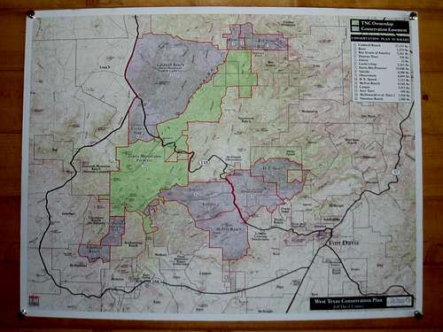
These peaks are located in the Davis Mountains Preserve, which is owned by The Nature Conservancy. Public access is limited to a few days and weekends per year, however, such restrictions keep this a truly wild and natural area in a state that is otherwise overrun by private, developped land.
The following has been copied from the TNC Davis Mountains Preserve web-page:
"The wild and remote Davis Mountains is considered one of the most scenic areas of Texas. Indeed it is one of the most biologically diverse. Rising above the Chihuahuan desert, the range forms a unique “sky island” surrounded by the lowland desert. Animals and plants living above 5,000 feet are isolated from other similar mountain ranges by vast distances. These are true ecological islands, preserving living remnants that occur otherwise nowhere else in Texas."
Having a prominence of 400' (122m) from Mt. Livermore, the Arrowhead on Mescalero Mountain is the 9th highest official summit in Texas (following the 300' "Colorado Rule" of prominence).
Getting There

Most visitors will approach the Davis Mountains from IH-10 coming from the west (El Paso) or the east (DFW and/or San Antonio):
- Exit IH-10 in the bustling hamlet of Kent, TX (Exit # 176)
- Drive south on TX-118 (roughly 32 mi) to the entrance of the Davis Mountains Preserve on the right (South). You will pass TX-166, a beautiful & scenic loop drive at ~20 mi. The entrance is barely noticeable when the Preserve is not open, and only marginally moreso on an open date. Look for a small sign low to the ground with some orange surveyor's tape tied to it. You'll drive over Beef Pasture Gap, a small saddle, just under a mile before the turn-off into the TNC property; if you reach the Madera Canyon Roadside Park (a few picnic tables), you've gone too far.
Others will approach the area from Fort Davis, TX:
- Drive approximately 20 mi west on TX-118 from Fort Davis, TX. You'll pass the Madera Canyon Roadside Park just before the entrance on the left (South). If you reach the TX-166 Scenic Loop turnoff, you've gone too far.
If all else fails, ask someone in Fort Davis for help / directions. Everyone I've met in the town is very friendly.
Red Tape
Mescalero Mountain lies on the land owned by The Nature Conservancy of Texas. The Davis Mountain Preserve is only open to the public a few days / weekends per year, so please check the calendar on their website for details.
For information regarding the Davis Mountains Preserve, please contact Jason Wrinkle at jwrinkle@tnc.org or (432) 837-5954.
2009 Calendar:
(Last updated on 27 Jul 2009)
Please, no pets allowed at Preserve events.
2009 Davis Mountains Preserve Events
- October 24 (Day hiking): The Preserve is open for self-guided hiking, birding and picnicking from 8:00AM to 4:30PM. Reservations are not required. - Contact: Jason Wrinkle at jwrinkle@tnc.org or (432) 837-5954.
- December 5 (Christmas Tree Hunt): Contact Jason Wrinkle for more information; jwrinkle@tnc.org or (432) 837-5954.
- December 12 (Christmas Tree Hunt): Contact Jason Wrinkle for more information; jwrinkle@tnc.org or (432) 837-5954.
Camping

Making the assumption that you're visiting on an Open Weekend, look no further than the Davis Mountains Preserve itself! Camping is usually free with plenty of tent / car / camper spots for the taking. If you're working on planning a trip, please contact Jason Wrinkle at jwrinkle@tnc.org or (432) 837-5954.
External Links
The Nature Conservancy - Davis Mountain Preserve - Link
hgrapid - Jun 7, 2021 9:13 am - Hasn't voted
Needs a lot of updatesNeeds updates on open days. Madera Canyon always open. Assume you can drive to trailhead?
willgotnochill - May 5, 2022 6:00 pm - Hasn't voted
Re: Needs a lot of updatesYou can find this years dates here- https://www.nature.org/en-us/get-involved/how-to-help/volunteer-and-attend-events/find-local-events-and-opportunities/tx-davis-mountains-open-days/ I did the Baldy/Mescalero loop in March- https://youtu.be/Mmquet5Qqqc