
|
|
Mountain/Rock |
|---|---|
|
|
40.42900°N / 105.56°W |
|
|
Larimer |
|
|
Hiking, Mountaineering, Toprope, Bouldering |
|
|
Spring, Summer, Fall, Winter |
|
|
10859 ft / 3310 m |
|
|
Overview
Dark Mountain is located within the northern confines of Rocky Mountain National Park and more locally, the Mummy Range. Dark Mountain is a small heavily forested peak sandwiched in between the Dark Canyon drainage and the Cow Creek drainage ~8 miles NNW of Estes Park. It derives its' name due to the fact that all sides of this enigmatic peak is rife with dense forest making it 'dark'. Due its proximity to the Black Canyon drainage, I think this may have had a hand in its being named thus. Dark Mountain is Rocky Mountain National Parks 104th highest peak.

Close up from a distance.
The summit of this mountain does not see many people. There are no trails or routes leading to its summit. Because of this, one is going to want to explicity climb this mountain and not just because its there. The ~2.6 miles (RT) of 'bushwacking' to gain its summit are much tougher than you'd think. There are only two trailheads available to climb this mountain. The entire northern flanks (180° cross-cut east-west) are similar dense forest with miles of wilderness until one reaches the Lost Lake trail in the extreme northern reaches of RMNP. Cow Creek drainage, Dark Mountain, Gem lake cannot be seen from Estes Park due to Lumpy Ridge which seperates Black Canyon and Cow Creek. This area is normally fairly dry however, Cow Creek does retain water for most of the year.
I would recommend climbing this mountain in the summer to fall seasons. I would NOT recommend climbing this mountain in the winter. The snow depth on the upper benchmark increases significantly the closer to the summit one gets. Snow on Dark Mountain is typically deep, untracked and on sunny days, becomes a wet, greasy nightmare. The summit is steep enough where if these conditions prevail, snowshoes are pretty much rendered useless. Postholing the remaining ~50ft. to the summit becomes a crapshoot of setting off a small slide, twisting or breaking an ankle/foot in the hidden deadfall or falling through a hollow spot. Because of the frequent sunny days and cold temperatures, the snow is quite often 'sugary'.
Season: May 15 - Nov 1
Difficulty: Moderate
Use: Low
USGS maps: Estes Park
Trailheads: Cow Creek
Restrictions: No pets are permitted
Suitable for mountain bikes: No (not permitted)
Suitable for horses: Yes
Getting There
Cow Creek Trailhead
40.4297 lat. 105.5006 long. (40° 25'46"N, -105° 30'2"W- DMS)
7,820ft. (2,383m)
Of the two logical access points for this mountain, this trailhead sees the most use but is not the only one.
From the town of Estes Park (central intersection), drive north on Macgregor Avenue as it swings westward past the Stanley Hotel to Devils Gulch Road. This is also Larimer County 43. Turn right onto CR 43. Follow this road north. At 1.7 miles from Estes Park, you'll pass a small parking area for Gem Lake on the left. At 3.4 miles, the road will turn gently to the right. At this bend, the road will continue straight to McGraw Ranch. Follow this dirt road as it weaves through private land for an additional 2.1 miles to its terminus at the McGraw Ranch and Cow Creek trailhead.

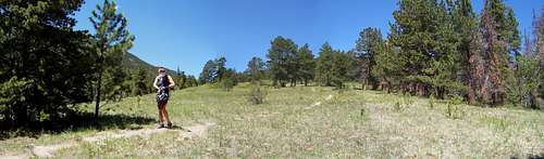
Just leaving the trailhead.McGraw ranch
From the Cow Creek trailhead, one cannot as yet see Dark Mountain. However, this is also the stepping off point for Bridal Veil Falls, North Boundary Trail, Gem Lake, Balanced Rock/Lumpy Ridge and a longer version to reach Lawn Lake deep in the heart of the Mummy Range. There is enough room at the TH proper for 3-4 vehicles. Because of gradual increased use of this area, additional parking has been implemented along the road. There is no potable water at the TH, however there are restroom facilities and an emergency phone.
The trail starts out as an access road bisecting the McGraw Ranch eventually diminishing to a double-breasted wagon track and finally to a single track. The lower portion of this trail is easy and straight forward. It follows Cow Creek through the meadow passing a few campsites and rock formations such as, "The Pear" and "The Book" along the way until the Bridal Veil spur is reached after 2.1 miles. Continue straight towards Lawn Lake. This second half is the Dark Canyon portion. The meadow will eventually disappear and the canyon will narrow. The trail continues to weave up the canyon through ever-denser forest with occasional switchbacks until it tops out at a saddle in between Dark Mountain, "Sundance Buttress" (the largest rock formation on Lumpy Ridge) and Macgregor Mountain. The saddle is 3.5 miles from the Cow Creek trailhead. The trail junction for Black Canyon is .1 mile down the other side of this gentle saddle where the trail continues on towards Lawn Lake and Stormy Peaks as the Black Canyon Trail.
Now, as said, there are no trails leading to the summit of Dark Mountain. There is however, a recommended route which follows the Southest slopes/shoulder which minimizes the deadfall and ravine crossings.
About ~.3 mile before the saddle, turn to your right and start to make your way up the hillside.
The coords. of this area are 40.4277 lat. 105.5876 long. The summit is 1 mile and 1,560 vertical feet (475m) away. At this point, the route finding is arbitrary as long as one stays on the shoulder. Because of the dense forest, Dark Mountain rarely comes into view and does so only at two points, at two particular rock out-croppings. Simply follow your instinct and keep hiking up. The first portion as one leaves the main trail will gain in elevation fairly quickly. This will eventually plateau out somewhat and become easier. Keep your NW heading through the forest and Dark Mountain will sneek into view once or twice. Plan your route based off the quick glimpses you see. The flat terrain will ascend again the closer to the actual summit one gets. At this point, the deadfall (downed timber, vegatation, rock & roots etc.) will increase significantly slowing ones progress. The trees in this area, at the summit's base are quite tall and large. They all but obscure the summit from view. Again, as long as one ascends in elevation, you're on the right track. The small southern face is the steeper. If one keeps angeling to the right, in other words, the immediate easten ridge, the pitch decreases a bit. The summit of Dark Mountain will appear quite suddenly and unexpectingly. It is a convoluted and rocky summit. But it does offer some great views of Rocky Mountain Park from a vantage that people rarely see. If off-piste treking is your 'thing', this mountain is great to practice GPS useage on.

Rock pinnacle
Length: 9.2 miles (14.8 kilometers- roundtrip)
Elevation Range: 7,820' – 10,859' (2,383'-3,310m)
Elevation change: 3,039 ft.
Grade: grade I, class II
Black Canyon Trailhead
7,920ft. (2,414m)
40.4241 lat. 105.5938 long. (40° 24'08"N, -105° 31'27"W- DMS)
The trailhead is located 1.1 mile from the main intersection in Estes Park. Take Wonderview Avenue north. It will gently curve to the west in front of the Stanley Hotel. Turn right at Macgregor Avenue and follow north for the remaining .7 mile to the ranch. The road will bend sharply at this point and eventually turn into Devil's Gulch road. Continue straight on the rough dirt road and simply follow the signs to the TH where the road ends. There are a couple of half-moon outhouses located at the trailhead and water. This is also the staging area for technical climbs up onto Lumpy Ridge.

Black Canyon & Lumpy Ridge
From the small parking area located here at Black Canyon TH, launch out towards the west, past the trailhead sign. The first .4-.6 miles of this trail pretty much just skirts the meadow and parallels Lumpy Ridge. As soon as the trail starts to climb up into Black Canyon, the shade will be a welcome relief as this area can get hot in the summer. The Black Canyon trail segment, from the TH to the junction with Dark Canyon on the west end of the saddle is only 1.6 miles; considerably shorter then following Cow Creek.

Twin Owls
I can't say which is more scenic because both have their pluses and minuses. However, Black Canyon TH would make for a more convenient and shorter day. At the junction with Dark Canyon trail, Dark Mountain, its' SE slope is the first prominant slope you see directly in front of you, a little off-right. I would actually recommend staying on the slope/mellow ridge. It might be tempting to follow the drainage/ravine up instead but you'll have to fight considerable deadfall and underbrush if you choose to do this.
From the junction, Lawn Lake is an additional 5.4 miles west (past Macgregor, Bighorn and Mt. Tileston on the left) and the Bridel Veil Falls spur trail is 1.4 miles to the east.

Start of Black Canyon Trail
Length: 6.2 miles (9.9 kilometers- roundtrip)
Elevation Range: 7,920' – 10,859' (2,414'-3,310m)
Elevation change: 2,939 ft.
Grade: grade I, class II
Red Tape
From the trailhead (Cow Creek) for the first .4 miles is located on National Forest. So there is some freedom as to what one can do. However, due to the historic designation of the ranch, all activities are prohibited. The Continetal Divide research group is currently using the buildings as a satellite base to conduct research. Because of this, admittance to the buildings is also prohibited.

McGraw Ranch.
The surrounding land east of the trailhead is private property and marked.
Upon entrance past the park boundaries, dogs and all forms of vehicular travel are prohibited including mountain bike.
Random camping, hunting, wood fires and fireworks are prohibited.
Parking along the road is done so only on the western side. Vehicles will be towed or ticketed by Park Rangers if parked on the easten side.
Horses and pack animals are allowed.
The small picture to the left is an artists overview of the ranch.
Camping
There are several designated sites within the confines of Rocky Mountain Park mandated for camping.
Rabbit Ears:This is located .8 miles from Cow Creek trailhead on the south side of the creek. There is one site available at this location and stoves only are permitted.
Peregrine:This is located 1.2 miles from Cow Creek trailhead and is also on the south side of the creek/trail. There is one site available at this location as well. Stoves only.
MacGregor:This is located 3.8 miles from the Cow Creek trailhead and just on the other side of the saddle. There are two sites available at this location and wood fires ARE permitted at this location.
Permits to camp at these campgrounds must be obtained at the Backcountry Office located behind the Fall River Entrance visitor's center to Rocky Mountain Nat. Park. Standing at the entance to the visitor's center, there is a dirt path located to the left just around a short rock wall. Follow this dirt path downwards to a small, brown, non-descript building. Go around to the south side of this building where the front door is located. Permits for all backcountry camping in Rocky Mountain Nat. Park are obtained here.
Fee: $15 May through October. November to April-no fee, but permits are still required.
Reservations may be made by phone from March 1 to May 15 for anytime during the year. From May 16 to September 30, reservations can only be made by mail or in person. During the winter and early spring when the backcountry is not as frequently used, you may self-register at the Wild Basin Winter Trailhead, Sandbeach Trailhead, Longs Peak Ranger Station, Dunraven Trailhead and Fall River and Beaver Meadows Entrance Stations.
During the busy summer months, if you have a permit reservation, you must pick up the permit by 10 am on the first day of your planned backcountry stay, otherwise, the permit will be cancelled in its entirety, and given to other backpackers. Payment, cash or check, is made when the permit is issued.
For a map to backcountry campsites, reservations and other backcountry literature,
Write:
Rocky Mountain National Park
Backcountry Office
Estes Park, CO 80517
Call:
(970) 586-1242
In case of emergency, please call 970.586.1203. This is the number for Park Headquarters. It will take approx. 15-20 minutes for a ranger to leave headquarters and arrive at Cow Creek trailhead.
Backcountry map of exsisting campsites. This is in .PDF format.
Historical Information
McGraw Ranch
The McGraw ranch located on Cow Creek has a long and complex history. This area was first homesteaded by Hank Farrer, a hunter. He built a log home, a milk house and a dirt-roofed shed on the property. In 1884, the ranch was purchased by Peter J. "PJ" Bauly Jr. who added to the existing structures by building a large barn, a bunk house, an icehouse, laid out corrals and added a new room to the old cabin.

The property from the main road.
He also installed a pond and a ditch system to support his growing cattle operation.
In 1897, Pauly's ranch was acquired by Hugo Miller, who, together with his cousin, Henry C. Rouse from Cleveland, Ohio had been purchasing land in the area some 10 years previous. Upon Rouses' death, Miller became the sole owner of the ranch, now well in excess of 1,000 acres. He renamed it the Double-Bar Ranch.
In 1908, because of his wife's ailing health, he deceided to lease the property which, at this same time, he was also operating as a small resort to a Mr. John M. McGraw.

The central log home.
The two men met in church some two years previous as McGraw and his wife were in the Estes Valley honeymooning. McGraw's lease ran for 25 years with the option to renew for an additional 25 years. After only two years into the first lease, John McGraw deceided to outright purchase the property for $16,000.
After John McGraws death in 1917, his widow, Irene and her two sons stayed on to run the ranch as a guest ranch while the cattle took a backseat. Frank McGraw (one of the sons) operated the ranch until 1979 when the core was sold and later became the Indian Head Ranch. In 1966, the McGraws sold off 834 acres to the NPS while retaining a small parcel for themselves. In 1988, the NPS acquired the remaining 220 acres.
In the early 1990's, the NPS wanted to raze the buildings thus returning the land to its natural state for elk and other wildlife. This proposition was met with fierce opposition. Together, with public funding, the buildings were saved and eventually restored and renovated. In 1998, the McGraw Ranch was added to the National Register of Historic Places.
McGregor Ranch
The MacGregor Ranch, situated at the mouth of the Black Canyon and akin to Lumpy Ridge, sits roughly 1.2 miles north of Estes Park. It is the oldest and continous cattle ranch in the Estes Valley. It dates back to 1875 when a small 160 acre parcel was filed by an Alexander Q. MacGregor and his new wife, Clara. Although both were from Wisconsin, they met out in Colorado someplace in between COlorado Springs, South Park and Estes Park. Clara was out in Colorado on an artistic/sketching trip set up by a professor back in Chicago. Alexander was a lawyer who was just admitted to the bar whereby he had planned to partner up with a Denver judge. When he met Clara, the two fell in love and moved to Estes Park. They started cattle ranching and farming.

MacGregor Ranch
Alexander MacGregor was responsible for many of the roads around Estes Park including what would later become highway 36, which leads down into the Lyons. He even offered use of one of his many buildings for the town Post Office. Eventually, the MacGregor Ranch grew to more than 2,000 acres and currently fuunctions as a working cattle ranch, youth education center and museum. Twenty eight of the 43 buildings on site are listed in the National Register of Historic Places.
External Links
Rocky Mountain National Park- Offsite
Rocky Mountain National Park- Wikipedia
National Park Service
BackcountryOffice
McGraw Ranch