
-
 33232 Hits
-
 90.81% Score
-
 33 Votes
|
|
Mountain/Rock |
|---|---|
|
|
39.38580°N / 106.0146°W |
|
|
Hiking, Mountaineering, Skiing |
|
|
Spring, Summer, Fall, Winter |
|
|
13352 ft / 4070 m |
|
|
Overview
Hoosier Ridge is the name for the 7 1/2 mile long ridge that runs along the Continental Divide from Hoosier Pass on the west end to Boreas Pass on the east end. The ridge (as well as the Pass) get their name from prospectors from Indiana who named it after their home state in the 1860's while searching for minerals in the neighboring Tenmile and Mosquito Ranges. The north and west sides are part of the Blue River drainage and water flows from these slopes to the Colorado River in Kremmling, and eventually to the Pacific Ocean.
From the southern and eastern slopes, water flows to the South Platte River and works its way across the plains to the Mississippi and Gulf of Mexico. Geologically, the western end of this ridge (which is Hoosier Pass) is the convergence of 3 mountain ranges, the Front Range to the east (which these peaks are a part of), the Tenmile to the northwest and the Mosquito to the southwest. This ridge is also the boundary between Summit County to the north and Park County to the south.
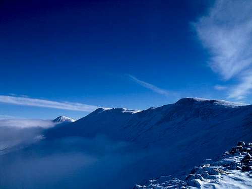
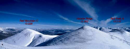
The highest point on the ridge is a ranked "13er" at 13,352' and is Colorado's 352nd highest ranked summit. Also on the ridge is the named Red Peak (A), a 13,215' unranked peak, and a ranked 12er, PT 12331. Red Peak (A) only rises 115' from its connecting saddle with the Hoosier Ridge highpoint and is really just one of many false summits on the ridge. Just to the north-northwest of the ridge's highpoint is a singular peak off the ridge crest, Red Mountain (C). This peak lies approximately 3/4 mile away and rises 369' from its connecting saddle to Hoosier Ridge. They along with Mount Silverheels to the south make up the farthest west 13ers in the Front Range.
These summits are a shutterbug's dream come true, from their suspended perch at the nexus of three mountain ranges they offer incredible views. The obvious one being the panoramic view of the Tenmile and Mosquito ranges to the west. On a clear day, the view stretches to include Pikes Peak to the east, the southern Sawatch range including the summits of Mts Antero and Princeton, and even distant views of the Crestones in the Sangre de Cristo mountains! The slopes of these peaks are gentle, and due to their location near Hoosier Pass, they are accessible year-round.
Getting There
The main point of access is Hoosier Pass, located on Colorado 9 approximately 11 miles south of Breckenridge and 5 miles north of Alma. The pass is at 11,539' above sea level, and is a popular place for those driving through to make a quick stop for a picture. There is a fairly large parking area to the west of the pass, and it serves as the trailhead for North Star Mountain as well. The trailhead is maintained in winter, however there are portions on the north side with an 8% grade and can be a rough drive in heavy snow.
The peaks can also be accessed from Boreas Pass to the east. The approaches from this side have less mileage, but more vertical gain. Boreas Pass is dirt, but usually accessible by any vehicle when dry. The pass is at 11,482' and is located 9 1/2 miles southeast of Breckenridge. To get here follow the Boreas Pass Road (initially paved) west from the traffic light just south of Breckenridge. Boreas Pass is named after the Greek God of the North Wind and once was home to the highest Post Office in the US. More information about the history of the pass can be found on the page for Boreas Mountain.
Routes
"Three Pointer": Class 2, 11 1/4 Miles RT, appx 3000' elevation (incl. false summits) RT
This is the standard way to climb Hoosier Ridge, Red Peak (A) and Red Mountain (C) together. Starting at Hoosier Pass cross the road and head east through the trees on an old road. This is also an access point for the Bemrose Ski Circus. As you break treeline you will see a long gentle slope rising ahead of you. Climb this for 1300' to PT 12814 to gain the ridge proper. The view may be daunting, as you see the sea of false summits that stretches out before you. Continue climbing for 2 1/2 miles to the true summit. From here continue out and back to Red Peak (A) or Red Mountain (C), each peak is .7 miles each way from Hoosier Ridge.
Note: If you decide to only climb Hoosier Ridge, the RT mileage is about 8 1/2 miles with 2500' of elevation gain.


"Hoosier Daddy": Class 2, 7 1/2 miles one way, appx 3060' elevation gain (one way)
With a car shuttle, the entire traverse of Hoosier Ridge from Hoosier Pass to Boreas Pass can be made with class 2 talus hiking. This traverse allows you to also collect the ranked 12er, PT 12331 aka "Madonna Dome". This route works in either direction, but due to the length of ridge that is above treeline on the Hoosier Pass side it is recommended West to East to minimize exposure to afternoon thunderstorms.
Red Tape
There is no private property to be concerned with on these peaks when climbing from Hoosier Pass or Boreas Pass.
Hoosier Ridge is included in the Hidden Gems Wilderness campaign, if passed by Congress the north and west sides (including Red Mountain C) would be part of a new wilderness area to be designated "Hoosier Ridge Wilderness". For more information, click here.
Camping
Due to their proximity to Hoosier Pass, camping at the trailhead proper is not recommended. There are options in the neighboring Tenmile and Mosquito Ranges, but developed campgrounds are limited.
In winter the Boreas Pass side offers two Mountain Huts, the Section House and Ken's Cabin. Reservations can be made at the 10th Mountain Division Hut Association's webpage: Huts.Org
Special Considerations/ Gear
Weather is always a factor when planning a trip to Colorado's High Country, the below link should give you an idea of what to expect for your trip: NOAA Forecast. Lighting is a big concern in summer, and much of the ridge is exposed above treeline.
You may also want to consult the local Ranger Station to find out any current information. Their offices are located in Fairplay and can be reached by phone at (719) 836-2031.
No special equipment is needed under normal conditions. In winter snowshoes or skis will be necessary below treeline and maybe above depending on how wind swept the ridge is. There is a cornice that forms on the south ridge of Red Mountain (C) and care should be taken if traversing between Hoosier Ridge and Red Mountain (C) in high avy danger. Avalanche forecasts are available here: CAIC Forecast for Summit County
Wind can be a concern and high winds are very common in the area. SP member Scott Patterson posted a trip report about a dangerous experience he had with high winds on a neighboring peak: Dangerous Winds
Annotated Map
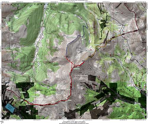
Overview of the Area - Click to enlarge