
-
 13705 Hits
-
 81.84% Score
-
 14 Votes
|
|
Mountain/Rock |
|---|---|
|
|
45.96443°N / 7.50272°E |
|
|
12192 ft / 3716 m |
|
|
Overview
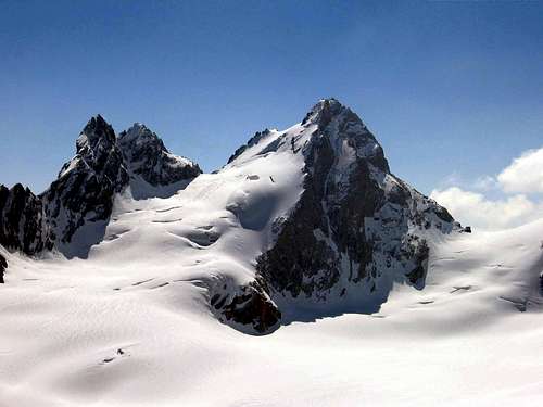
Nice pyramid made of red gneiss. The french name "evèque", in english means "bishop". This because till the 1875 all the Arolla valley belonged to the bishop of Sion village.
The shape of this mountain is basically a square pyramid. The north flank, very nice and totally covered by a glacier which is part of the bigger Collon glacier; it's the side where the normal route goes across.
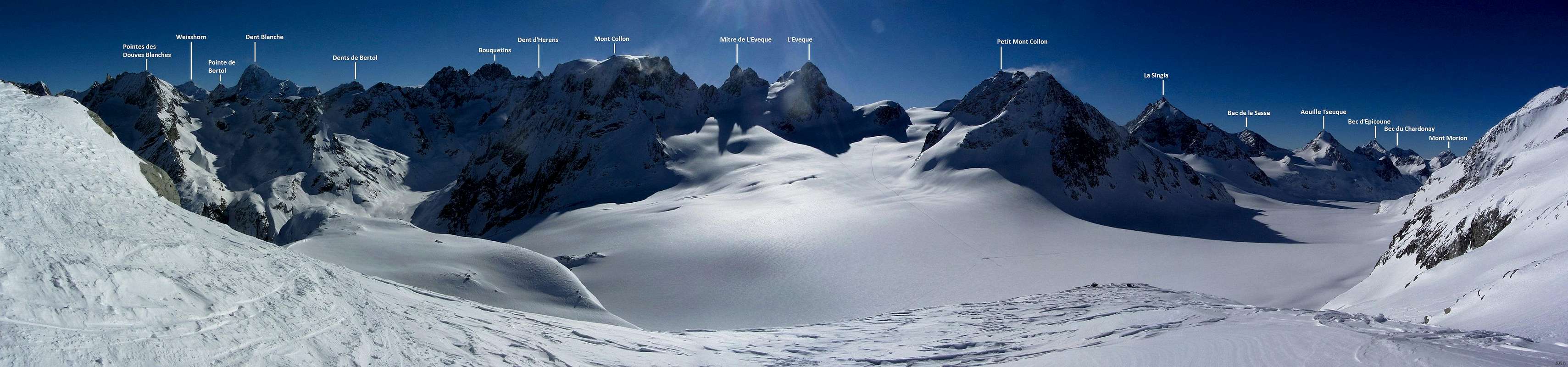
The rest of the mountain is composed by three steepy and rocky flanks, that stand out directly from the galciers Collon and Arolla. The pinnacle called "Mitre de l'Evèque" (3.654m), is also part of this mountain.
It is composed by two summits and placed between Mont Collon and the higher Evèque. It's not commonly climbed due to the bad rock quality and the closeness of more famous mountains.
The Evèque is an important mountain situated along the hauteroute "Camonix-Zermatt", this is why it's often climbed on ski in springtime.
Getting There
Area reachable from Italy and Swizzerland.Route from ITALY: via Valpelline-Comba d'Oren-rif Nacamuli. From Turin, Milan. Leave motorway A5 in Aosta Est, then follow Grand Sant Bernard tunnel direction. Once passed Valpelline village, take the direction to lake of Place Moulin.
Route from SWIZZERLAND: via Arolla. From Geneva, Sion. Arolla is the topmost village of the uppermost valley of the Val d'Hérens. In former times, you could reach it only on foot. Now, there exists a road. You reach Arolla by car from Sion via Evolène and Les Haudères.
Routes

NORTH FLANK (B) Normal route, from glacier Collon 1h'00/2h'00 (PD/BSA).

EAST FLANK AND NORT-EAST RIDGE (C) From Col collon 4h'00/5h'00. Bad rock quality and not recomended.
EAST RIDGE From Col Collon, 550 meters. (V/V+).

SOUTH-WEST RIDGE (A) From Col de l'Evèque. Very nice and good rock (III/IV).
Accomodation


Italian side Refuge Nacamuli-Col Collon 60 places. (2.828m) at the head of Comba d'Oren. 3h'00/4h'00 from the dike of Place Moulin. Open summer and spring for ski-mauntaineering. Difficulty EE Rifugio Nacamuli
Swiss side Refuge des Bouquetines 25 places. (2.980m) at the head of Glacier d'Arolla. 3h'00/4h'00 from Arolla. Open summer. Tel 0041 21 845 63 21. Difficulty F Refuge des Bouquetines
Cabane des Vignettes 125 places. (3.160m), situated near the "Col des Vignettes". 3h'00/4h'00 from Arolla. Tel. 0041 27 283 13 22. Open summer and spring. Difficulty F Cabane des Vignettes
Gear
For Mountaineering with rope, ice-axe and crampons.
Da Alpinismo con corda, piccozza e ramponi.
Camping
Remember that free camping is forbidden (except for emergency reasons, over 2.500m, from darkness until dawn).
Mountain Conditions
- You can get meteo information at the official site of the Regione Valle d'Aosta:
- Valle d'Aosta Meteo
Webcam
- WEBCAM on Aosta Valley:
- Webcam
Books and Maps
BOOKS:
- "Guida delle Alpi Occidentali", di Giovanni Bobba e Luigi Vaccarone C.A.I. Sezione di Torino Volume II (parte II), 25 Maggio 1896.
- "Guida dei Monti d'Italia-Alpi Pennine" (Vol. I°) di Gino Buscaini-Club Alpino Italiano/Turing Club Italiano, Luglio 1971 (in Italian).
- "Diari Alpinistici" di Osvaldo Cardellina e Indice Generale accompagnato da Schedario Relazioni Ascensioni 1964-2019 (unpublished).
- "Guida della Valpelline" de l'Abbè Joseph-Marie Henry - Societè Editrice Valdotaine 1925 II Edition e Collana Reprint Musumeci (1986).
- "Rifugi e bivacchi in Valle d'Aosta" di Cosimo Zappelli aggiornata da Pietro Giglio. Musumeci Editore, Luglio 2002 (in Italian).
 |
 |
 |
MAPS:
- Kompas "Breuil Cervinia Zermatt" Sentieri e Rifugi Carta turistica 1:50.000.
- L'Escursionista "Valpelline, Saint Barthélemy" (carta n° 6) 1:25.000.
- I.G.C. Istituto Geografico Centrale "La Valpelline, Ollomont, Saint Barthélemy", (carta n° 115) Map1:30.000.
- Carta Nazionale Svizzera "Foglio Valpelline" 1:50.000.
Important Information
- REGIONE AUTONOMA VALLE D'AOSTA the official site.
- FONDAZIONE MONTAGNA SICURA Villa Cameron, località Villard de la Palud n° 1 Courmayeur (AO) Tel: 39 0165 897602 - Fax: 39 0165 897647.
- SOCIETA' DELLE GUIDE DELLA VALPELLINE Etroubles-Strada Nazionale, n° 13 - Tel +39 0165 78559 - Valpelline-Loc Capoluogo, n° 1 - Tel +39 0165 713502 (AO) Italia.
- A.I.NE.VA. (Associazione Interregionale Neve e Valanghe).
Useful numbers
- Protezione Civile Valdostana località Aeroporto n° 7/A Saint Christophe (Ao) Tel. 0165-238222.
- Bollettino Meteo (weather info) Tel. 0165-44113.
- Unità Operativa di Soccorso Sanitario Tel. 118.
desainme - Apr 5, 2014 7:32 am - Voted 10/10
Elevation oops3716 ft / 1133 m is a typical elevation of a mountain in the Appalachians This mountain is approximately the height of Teewinot. Probably 12,200 feet or so.