
|
|
Mountain/Rock |
|---|---|
|
|
56.64896°N / 5.02187°W |
|
|
Lochaber |
|
|
Hiking, Trad Climbing, Ice Climbing, Scrambling |
|
|
Spring, Summer, Fall, Winter |
|
|
3658 ft / 1115 m |
|
|
Overview
Overshadowed by her marginally higher neighbor, Bidean nam Bian, to which she is connected by means of a col just a few meters too high to give her Munro status, Stob Coire nan Lochan is most often just used as a stopping point with a nice view for munrobaggers trying to bag Bidean and Sgreamhach in a wee round.Too bad, in my opinion, as this mountain, still one of the tallest in Argyll, offers lots of interesting climbing on it's north face, and short walk-in times from the main road. The crags start at around 830-850 meters, and go right up to the pyramid-shaped summit.
Rock around here is mainly rhyolithic/andesite lava, with a granite core because this used to be the center of the Glen Coe caldera. Because the center of this ancient supervolcano (think Yellowstone) lies right around the Three Sisters, anyone interested in geology as well as climbing is going to have the time of their life here. The summit of Stob Coire nan Lochan consists almost entirely out of rare Andesite pillars, and the bottom of the coire itself cuts into the granite of the old magmachamber.
Getting There
By public transport: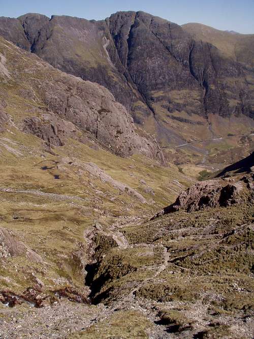
Halfway up the coire, view over Glen Coe.
Get off the bus at the second parking lot after the opening of the Pass of Glencoe, when coming from Bridge of Orchy, or the first parking lot before when coming from Fort William / Glen Coe village. Usually the driver will drop you off at the right spot when you'll ask to be dropped off at the Three Sisters. Busses run from Fort William and Bridge of Orchy about five times a day, both Bridge of Orchy and Fort William are served by Scotrail on the West Highland line.
By private vehicle:
Park your car at either one of the parking lots on the A82 near the Pass of Glen Coe. The A82 runs from Glasgow/Dumbarton to Inverness through Crianlarich, Glen Coe, Fort William and Invergarry.
From Edinburgh: M9 to Stirling, A84/85 to Crianlarich, A82 to Glen Coe.
From Aberdeen: A96 to Keith, A95 to Kingussie, A86 to Spean Bridge, A82 to Glen Coe.
By Helicopter:
The parking lot closest to the Pass is equipped with a landing pad for a helicopter, although I highly doubt overnight parking is allowed for this particular vehicle.
Scottish Outdoor Access Code
Know the Code…Access rights come with responsibilities which are fully explained in the Scottish Outdoor Access Code, though the main thing is to use common sense. You need to take responsibility for your own actions, respect the interests of others and care for the environment – what does all this mean?
When you’re in the outdoors, you need to:
* Take responsibility for your own actions - The outdoors is a great place to enjoy but it’s also a working environment and has many natural hazards. Make sure you are aware of these and act safely, follow any reasonable advice and respect the needs of other people enjoying or working in the outdoors.
* Respect people’s privacy and peace of mind - Privacy is important for everyone. Avoid causing alarm to people, especially at night, by keeping a reasonable distance from houses and private gardens, or by using paths or tracks.
* Help farmers, landowners and others to work safely and effectively - Keep a safe distance from any work and watch for signs that tell you dangerous activities are being carried out, such as tree felling or crop spraying. You can also help by:
- leaving gates as you find them;
- not blocking or obstructing an entrance or track;
- looking for alternative routes before entering a field containing animals;
- not feeding animals;
- using local advice so that you can take account of shooting and stalking;
- not damaging fences or walls; and by
- avoiding damage to crops by using paths and tracks, by using the margins of the field, or by going over ground that hasn’t been planted.
* Care for the environment – Our environment contributes greatly to everyone’s quality of life and health. It’s important that you:
- follow any reasonable advice and information;
- take your litter home;
- treat places with care, leaving them as you find them;
- don’t recklessly disturb or intentionally damage wildlife or historic places.
* Keep your dog under proper control – If you have a dog with you, it’s very important that it doesn't worry livestock or alarm others. Don’t let it into fields with calves or lambs, and keep it on a short lead or under close control when you’re in a field with other animals. If cattle react aggressively to your dog, let go of it immediately and take the safest route out of the field. Take care to ensure that you or your dog don’t disturb breeding birds. Pick up your dog’s faeces if it defecates in any place where it is likely to cause concern to other people.
* Take extra care if you are organising a group, an event or running a business – Consult the full Code for information about your responsibilities.
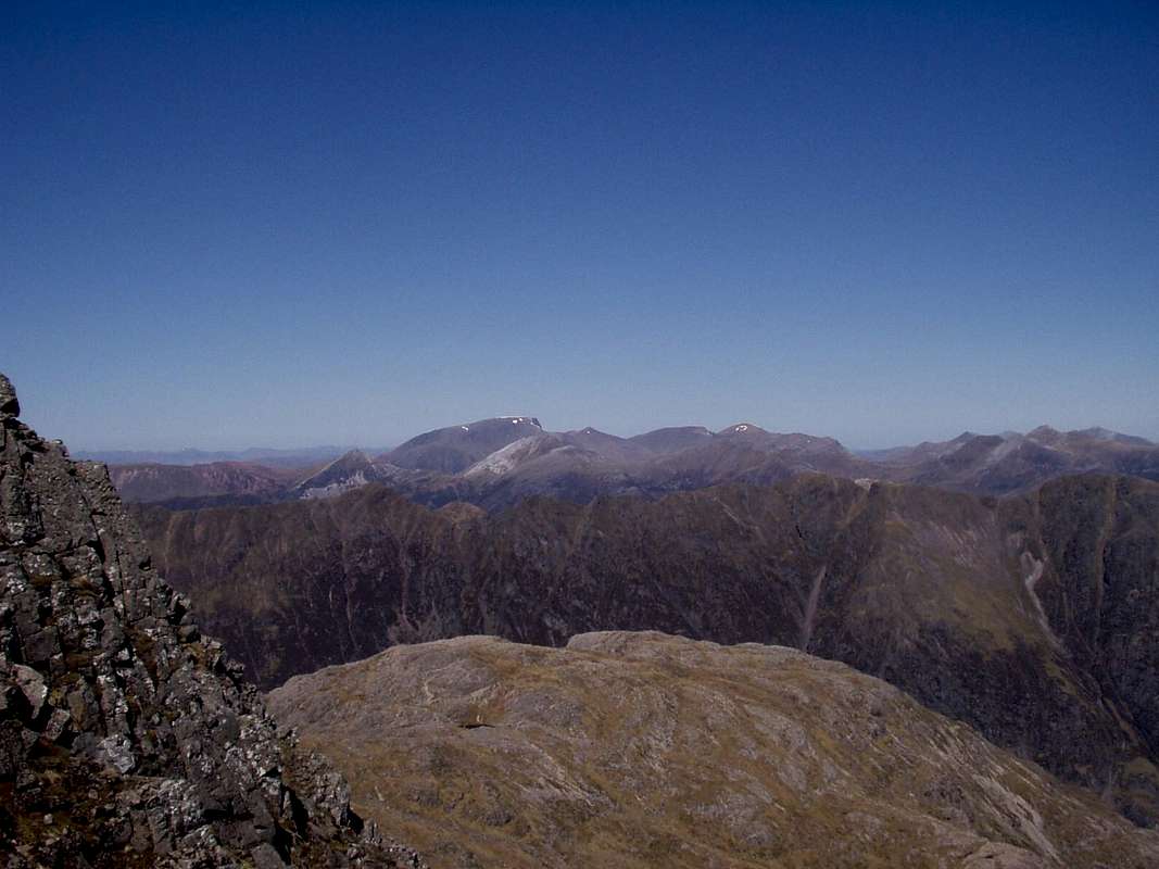
Looking north from the crags, the rounded hill in the foreground is Aonach Dubh, the most westerly of the Three Sisters, 892 meters, on the other side of Glen Coe the "Notched Ridge" or "Aonach Eagach" is visible, with Sgurr nam Fiannaidh at 967 meters, and the ridge in the background is the Nevis Range, with Ben Nevis' snowy summit, 1344 meters. Inbetween the Notched Ridge and the Nevis Range are the Mamores.
Camping
As mentioned above, camping is allowed everywhere in the area.
Glen Coe and the Lower Coire nan Lochan with camping spot by the river Coe.
In my opinion, there are two excellent places around the coire for camping; near the river Coe, just east of the mouth of the coire, where the river Coe comes out of a gorge, and up at the lochan plateau. Both places are fairly sheltered, and each place will be suited differently for your objectives and your personal comfort level.
The best place for most activities and general hillwalking is to camp near the river Coe, on dry ground, with ample access to fresh water. Most rivers in the remote parts of Scotland provide water which is drinkable without treatment, for at least 10 months out of the year. This place is no exception, usually you can drink the water here straight from the river. If in doubt, always boil of course. Also, by camping here you're sure that nobody is camping out at least 500 meters upstream from you, because there's a gorge preventing that.
Another option is to camp on the high plateau near the lochans, at around 760 meters. To reach this point, a trail needs to be followed with an average gradient of around 30-35%, topped off with a wee bit of class 3-4 scrambling depending on your route. This is an excellent, if not the best, starting point if you want to spend a few days in the area, exploring all of the crag, and can't be arsed carrying your rack up and down the hill multiple times. This is less of an option though during winter, unless you're experienced and comfortable with Scottish winter climbing, because having to scramble iced class 4 rock in a snowstorm with a 30 lbs pack can be a liability by itself, if not extremely uncomfortable and annoying.
In winter, it's also all too possible that you get stuck here because of weather, whereas down in the Glen you can just pack up and head for the road.
Also, you need to keep in mind that during winter there is no water source here, because the lochans will be frozen solid, so you would need to melt snow or carry water in. When the lochans are not frozen, make sure to always treat or boil that water, because they are a fairly stagnant source of H2O.
Climate and daylight
Scottish weather is well known for its unlikeliness to stay stable for more than a few days, or even hours. Best bet is May, when the days are long, midgies aren't out in large numbers yet, and chances of a prolonged dry-spell are at their greatest.I've made the following table using climate data for Oban, and daylight data for Fort William. Both represent average conditions in Lochaber very well. a few notes:
*) The "daylight" mentioned in the table includes civil twilight, so it should be read as 4 hours of darkness in June, and 18 hours in December.
*) Oban is at sea level. For the Lochan Plateau, subtract 5°C, for the summit of both Bidean and Stob Coire, subtract 8°C, and double for windchill.
| Month | Avg Low | Avg High | Precipitation (mm) | Wet Days | Daylight (Hours) |
| January | 2°C | 6°C | 146 | 20 | 7 |
| February | 1°C | 7°C | 109 | 17 | 10 |
| March | 3°C | 9°C | 83 | 15 | 13 |
| April | 4°C | 11°C | 90 | 17 | 16 |
| May | 7°C | 14°C | 72 | 16 | 18 |
| June | 9°C | 16°C | 87 | 16 | 20 |
| July | 11°C | 17°C | 120 | 20 | 19 |
| August | 11°C | 17°C | 116 | 19 | 17 |
| September | 9°C | 15°C | 141 | 19 | 14 |
| October | 7°C | 12°C | 169 | 21 | 11 |
| November | 4°C | 9°C | 146 | 20 | 8 |
| December | 3°C | 7°C | 172 | 22 | 6 |
Maps
OS Explorer sheet 384 Glen Coe & Glen Etive
OS Landranger sheet 41 Ben Nevis

Lower coire nan Lochan up to the Lochans

Upper Coire nan Lochan, crags and summit.