
|
|
Mountain/Rock |
|---|---|
|
|
39.31444°N / 119.94583°W |
|
|
Washoe |
|
|
Hiking |
|
|
Spring, Summer, Fall, Winter |
|
|
10335 ft / 3150 m |
|
|
Overview
Sitting just northeast of Lake Tahoe, Relay Peak is the highest point on the Tahoe Rim Trail (TRT). In fact, at 10,335 feet, it is one of the highest peaks in the Lake Tahoe Basin. However, it is generally overshadowed by its nothern neighbor, Mount Rose. Because the summit is rather easy to reach and requires only hiking mostly on a dirt road, it generally isn't a major goal for peakbaggers. Most routes to the summit are easy and moderate in length, except for one long approach that starts at Brockway Summit.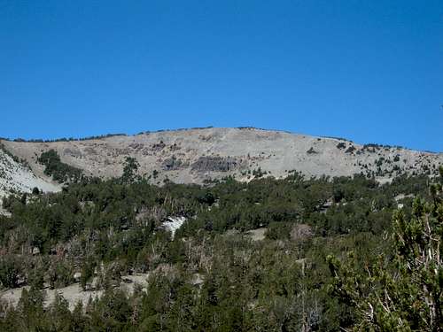
Relay Peak from the service road
Still, for anyone who visits Relay Peak, they will be greeted by excellent views for most of the way up, especially of Lake Tahoe and the surrounding peaks to the south. The views at the summit are even better, where many of the southwest and western Tahoe peaks can be seen. In addition, Castle Peak, Basin Peak, and Sierra Buttes are visible to the north. Even Lassen Peak is visible if you look for it.
Because of its proximity to Reno and Carson City, Relay Peak is commonly hiked and has lots of hikers walking dogs on the route during the summer. Due to its wide, easy to follow trail, it can easily be snowshoed during the winter months.
Getting There
Getting to Relay Peak is easy. From Reno take 395 to the Mount Rose Highway (431). Take 431 until you reach the Mount Rose Summit Parking Area (8,911'). The route to the summit starts at the west edge of the parking lot at the same place as the Mount Rose Trail. This is the start of the main trail to the summit. However, there are at least four noteworthy ways to reach the summit of Relay Peak.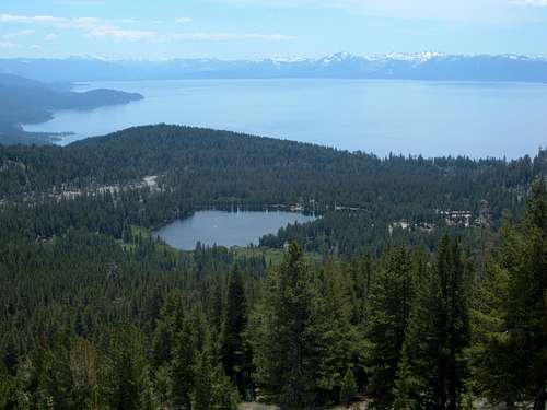
View of Incline Lake and Lake Tahoe from the trail
1) From Mount Rose Summit parking area to the Relay Peak Service Road
Round Trip Distance: ~9 3/4 miles
Elevation Gain: 1500 feet
This is a day hike or hike/run from the Mount Rose Summit parking area. The trail to Relay Peak is marked at the entry to the trail. It says 3.9 miles to Relay Peak, but maps say this is more than five miles. From my experience, and from the distance markers, I estimate that the route is roughly 4 3/4 miles. From Mount Rose Summit, you take a trail south for 3/4 miles until it reaches the service road. Take the service road for just over 2 miles and you will see a sign for the trail to Mount Rose. At this point, you will also see a sign saying it is two miles to Relay Peak. I found this sign to be pretty accurate. After another 1 1/2 miles you reach the Tahoe Rim Trail. A sign points the way to Relay Peak, which is only 1/2 mile away with little more than 200 feet of elevation gain left to go. It is easy to run part of this route up, and run down during the summer if you enjoy trail running. That makes for a much shorter day.
2) From Tahoe Meadows (east end) up the Relay Peak Service Road
Round Trip Distance: ~9 1/4 miles
Elevation Gain: 1750 feet
Just west of Mount Rose Summit is the east end of the Tahoe Meadows parking area (not to be confused with the west end of the Tahoe Meadows further down the road where the Tahoe Rim Trail starts). From the east end of the Tahoe Meadows cross Highway 431 and take the Relay Ridge service road from its starting point. The road meets up with the trail from Mount Rose Summit route after 10 minutes or so. The total round trip distance is pretty similar to the route from Mount Rose Summit, while the elevation gain is about 250' greater.
3) East Ridge route
Round Trip Distance: 5 3/4 miles to 8 miles
Elevation Gain: 1500-1750 feet depending where you start
You can start this route from either Tahoe Meadows or the Mount Rose Summit parking area. About 1 1/2 miles in from the start of the service road, you can descend into the woods, and bushwhack up to the ridge and head directly up to the summit. There is no defined trail, so you just have to follow the ridge as it goes up to meet the main Relay Ridge just south of the peak. This is difficult in snow, but far more straight-forward when the route is clear. If you ascend this way, and descend via the Relay Peak Service Road, the hike is closer to 8 miles. A loop is recommended if ascending via the steep east ridge.
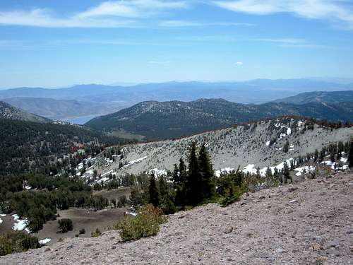
Southeast Ridge route with red markings
4) From Brockway Summit (California)
Round Trip Distance: 28.8 miles
Elevation Gain: >3500 feet
Brockway Summit is located in California, at an elevation of about 7200 feet. It can be reached by traveling on Highway 267 between Truckee and Kings Beach to the turnoff for Forest Service Road 16N56 on the north side of the highway, 2.75 miles northwest of Kings Beach. There is a parking lot for the Tahoe Rim Trail just southeast of Brockway Summit. This trail is very long and takes more than one day. Low impact camping is allowed on the trail. In other words, don't bring matches. One bright spot for this route is that it is an opportunity to climb a long section of the Tahoe Rim Trail.
dscharfman - Aug 24, 2009 10:38 pm - Hasn't voted
5th route to Relay15 years ago I took a 5th route to Relay Pk - from the lake shore - combined run/hike. From the shore, run up Country Club to the end, go left .1 miles, then right and up Jennifer to the end (7400ft). Pick up the remains of a trail near the bed of 3rd Creek, and start the fun. Climb into the valley a little, then slab up to the left (west) to around 8200 feet at the crest of the ridge - right at treeline. Follow the easy but spectacular ridge to the summit of Rose Knob Peak (9710 with unbelievable views all the way). Hop over the top to the Rim Trail, and follow it to Relay's south ridge. Follow the ridge to the summit. You can run all but the steepest parts...took me 3 hours. Come back either via the road or down the sharp SW ridge of point 9561, but that's sort of brushy. 4500 vertical each way, and one heckuva day trip.
hgrapid - Aug 25, 2009 11:43 am - Hasn't voted
ThanksThat is a long trip! Notice that one of the routes is from Brockway Summit, and that is almost 30 miles. As for adding your route, I don't think it is necessary to suggest routes longer than 12 miles to Relay Peak as alternate routes. The fact is that there are many ways to hike Relay Peak via long routes. Relay Peak is very accessible because of all the roads and trails around it. For the purposes of this page, I want to focus on the most direct routes. The only reason I mention Brockway Summit is because trail maps provided by the US Forest Service describe the route, and it is the Tahoe Rim Trail section.
sierra jenie - Aug 18, 2018 11:10 am - Hasn't voted
Relay PeakNice hike... best route for me is TRT: soft dirt & tree cover. Service road is hard packed with no tree cover.