
|
|
Mountain/Rock |
|---|---|
|
|
46.74100°N / 121.696°W |
|
|
Scrambling |
|
|
Spring, Summer, Fall |
|
|
6780 ft / 2067 m |
|
|
Overview
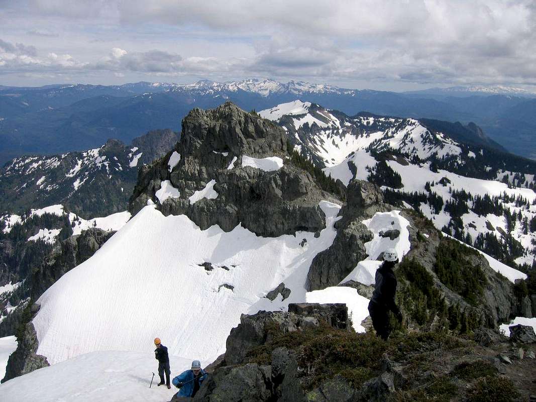
Boundary Peak is located in the Tatoosh range and, as the name suggests, is located barely north of the southern border of Mt. Rainier National Park in Washington State. The second highest peak in the Tatoosh Traverse, Boundary lies just to the southeast of Unicorn Peak and southwest of Stevens Peak on the eastern end of the range. Boundary's rocky summit commands a 360-degree view of the area and, of course, Mt. Rainier to the north across the valley.
Boundary Peak probably receives fewer visitors than nearby Unicorn - most likely tagging the summit on their way through the Tatoosh Traverse. The easiest approach is a walk-up/scramble route on Boundary's southeast ridge. This peak can be easily combined with Unicorn -- or other peaks along the Traverse for a full day outing.
Boundary is probably best done in late spring/early summer when snow covers the route up from Unicorn - although it can probably be climbed all year. There is likely some avalanche hazard on the approach and large cornices that build up on the ridge between Unicorn and Boundary. In the winter the Stevens Canyon Road is not plowed.
Getting There
From Portland:Take I-5 to exit 68. Turn east onto US Highway 12 and continue ~30mi to Morton and turn right on Hwy 7 North following to junction in the small town of Elbe. Turn right and follow this road through Ashford into Mt. Rainier National Park. There are signs for Mt. Rainier National Park at all junctions.
From Seattle:
To reach the West entrance by Longmire, take Hwy 7 for ~35mi from Tacoma south to Elbe. At the junction, follow the signs to Mt. Rainier National Park and drive East about 15 miles to the park entrance.
Once inside the park, follow the main road up past Longmire and continue east at the junction towards Ohanapecosh and onto Steven's Canyon Road. Continue about 3mi east of the Reflection Lakes to the Snow Lake trailhead (signed). There is a large pull-off for parking on the east side of the road.
Red Tape
A fee must be paid on entering Mt. Rainier National Park.Route Beta
From the trailhead along the Steven's Canyon Road, a well-maintained trail leads ~1mi to Snow Lake. Bear right there and follow the valley south about 0.5mi and up a narrow draw (~40 degree slope) into a large bowl below Unicorn Peak. Bear left here and head upwards on a steep slope to an obvious saddle just west of Unicorn. At the top, bear left and scramble upwards (you may need to cross a moat here). Head up a snowfield and scramble upwards to a large sub-summit of Unicorn (the true highpoint is along the ridge to the north). From here, Boundary is visible as a large rocky outcrop just down the southeast ridge.Drop down the ridge wherever is easiest. In early summer (late-June) a user-path may have been melted out. Navigate your way down, scrambling down several minor cliffs and pushing through trees. Beware huge cornices that build up on the ridge in winter. Traverse south (climber's right) around several rocky pinnacles to reach the summit block of Boundary. Scramble up wherever is easiest -- if it looks too difficult keep traversing right/south until the gullies get easier. It appears that by circling all the way around the SE ridge there may even be a walk-up route. Scramble up to the summit.
Camping
There is camping permitted within the park. The closest car-campground is at Cougar Rock north of Longmire. A trailside camp is located near the base of the approach at Snow Lake - consisting of two primitive campsites located near the north end of the lake sharing a pit toilet and bear pole. A backcountry permit (available at the Wilderness Information Center in Longmire) is required for off-trail camping up in the Tatoosh Range; group size is limited to five.External Links
Mt. Rainier Trail ConditionsThis site posts the current trail conditions for the Mt. Rainier area -- the status of the Snow Lake trail can give you a good idea of what to expect at least on the first part of the approach.
Paradise WebCam
Mt. Rainier Paradise webcam. On a good day, Eagle Peak (western end of the Tatoosh) is visible left-center -- this can give a good approximation of conditions in the area.
Mt. Rainier Recreational Forecast