
|
|
Mountain/Rock |
|---|---|
|
|
43.54515°N / 73.96237°W |
|
|
Warren |
|
|
Hiking |
|
|
Spring, Summer, Fall, Winter |
|
|
3254 ft / 992 m |
|
|

Summit sunrise

Summit view

Summit view

Garnet Lake

Pond View
Overview
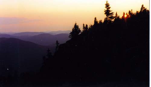
Sunset near the summit
Crane mountain in the southern Adirondacks is the most used, most appreciated and most interesting mountain in the area. All the sides you can conveniently see or get to are very steep.
Not only are there incredible views from the summit, but there is also a very beautiful pond on its shoulder. At the right season it is full of blueberries. The area around the pond is a popular camping area. Just make sure to camp only in designated areas.
There are two trails to the summit (both with very steep sections) which makes a loop trip possible. The shortest route to the summit is about 1.4 miles with an ascent of about 1150 feet. This route to the summit has a ladder near the top which avoids a short scramble on a rocky pitch. There also may be another short ladder, part way up this trail. There are nice views as you ascend the trail along side trails or the trail itself at several locations, not hard to find.
The second optional trail to the summit leads directly to the pond. This direct trail to the pond crosses its outlet stream near to the pond circles part way around the pond and then climbs steeply to the top and is typically called the Putnum Trail.
In the vicinity of the pond outlet is a faint herd path going north (and a little west) out onto a shoulder of the mountain often called the Northwest Ridge.
There is also a second loop from the pond to the summit and back to the pond. The trail from the pond to the summit is probably the steepest climb on the mountain.
The pond itself is stocked with trout anualy and always provides a refreshing swim, if you can handle the cold water.
The Trailhead

Trail Sign

Final ladder
To reach the trailhead from Rt 8 in Johnsburgh turn south onto South Johnsburgh Road. Then take a right on Garnet Lake Road in the Hamlet of Thurman. Travel 1.4 miles to a right hand turn with a Brown and Yellow DEC sign poiting the way to Crane Mt. This section of road is on dirt and can be rough at times so caution is advised. Continue 2 miles to a small dirt road on the right. This road can be very bad, and is sometimes flooded by beaver activity. You may chose to park here and walk the half mile to the trailhead parking area. If you do drive this section go very slow, watch the ruts and rocks in the road. The parking area has room for about a dozen cars.
The trails

basic map of trails, and places of interest

Standing on the summit

Crane Mt. pond from above
From the trail head register (20 ft from the north end of the parking area) the sign indicates 1.8 to the summit and 1.4 to Crane Mt Pond along the right trail. The left trail leads 1 mile to the Putnum Junction and 1.9 miles to the pond.
Climbing the more direct right trail to the summit, the first view is on the left at about .5 miles on a side trail. At.7 miles a junction is reached with the trail going left .4 miles directly to the pond. Continue to the right to reach the summit. Just before the summit a ladder is placed to navigate up a rock ledge to the summit ridge. The summit is soon after at 1.4 miles. Once a fire tower stood here and the old remains of the foundation and ranger cabin are still to be found. The trail will continue over the summit ridge and drop steeply down to the pond.

Natural Stone Bridge over Putnum Brook
The trail leading left from the original trailhead leads along an old road along Putnum Brook to the Putnum Junction. The trail turns right here and heads up to the pond. At this junction make sure to check out the cave under the natural rock bridge where Putnum Brook flows under the trail. It is easy to go under the trail here, but caution must be used to descend into the cave where the stream disapears under ground. I've never been in there so have no clue what is in there but I know people do go in and explore.
From the outlet of the pond a faint herd trail leads out onto the northwest ridge. It is unmarked but relatively easy to follow. It's pretty open the entire way and great views can be found. Once you've reached as far as you can simply turn back and head to the pond.
Red Tape
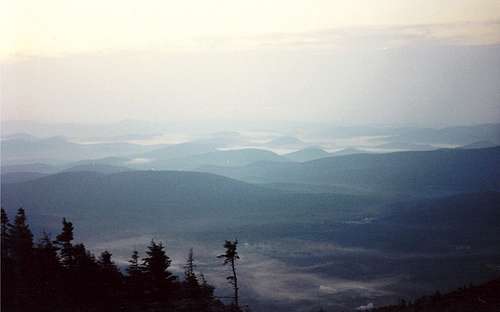
Is it an ocean view in a storm? No this is a foggy valley at dawn from Crane Mt.
1 Fire
a. No fires are permitted except for cooking, warmth or smudge. No fire shall be lit until all flammable material has been removed from its perimeter as is necessary to prevent its spread. No fires shall be left unattended until extinguished.
b. No person shall deposit lighted matches, cigars, cigarettes or other burning tobacco where they will cause fire.
c. No wood, except from dead and down trees or from supplies furnished by the department, shall be used for fuel.
2 Official signs and structures
a. No person shall deface, mutilate or destroy any department sign, structure, barrier or object.
b. No person shall throw, dump, deposit or place or cause to be thrown, dumped, deposited or placed on or in any department lands or structures any refuse, trash, garbage, rubbish, litter or any nauseous or offensive matter.
3 Camping sites
a. Areas used for temporary camping and adjacent lands under the jurisdiction of the department must be kept in a neat, clean and sanitary condition. Garbage and refuse must either be deposited in receptacles provided, or removed.
b. Camping is prohibited within 150 feet of any road, trail, spring, stream, pond or other body of water except at camping areas designated by the department.
c. No person may pollute in any manner nor deposit waste material of any kind in or on waters under the jurisdiction of the department.
4 Camping permits
a. Temporary camping in one location for four nights or more is prohibited except under permit. Except during the big game hunting season, no temporary camping permit will be issued to any person for a period in excess of 14 consecutive nights. No temporary camping permit may be renewed, or a new permit issued, to the same person for the same location in the same calendar year.
b. Temporary camping is restricted in certain posted areas and no person may camp on such areas without a permit.
c. Upon termination of camping all equipment and supplies must be removed from State land. The storage of personal property on State lands is prohibited.
d. No temporary camping permits will be issued to individuals under 18 years of age.
e. No group of 10 or more individuals may camp on State lands at any time except under permit.
External Links
NY State Department of Environmental Conservation
ADK (Adirondack Mountain Club)
Adirondack Forum
jayclimbs - Oct 24, 2010 9:24 pm - Hasn't voted
Technical Rock Routes on CraneThere are well over 100 technical rock climbing routes on Crane Mountain. Most of them are under 100', single pitch lines between 5.5 and 5.10. The most accessible routes lie on cliffs beside the main hiking trails: the Viewpoint Slabs and the Summit Ridge cliffs. However, since 2008, many stellar routes have been climbed east of the trails, along a path leading to the Black Arches Wall.
birdny - Nov 8, 2010 9:54 pm - Hasn't voted
Re: Technical Rock Routes on CraneThanks for the brief info. I dont do any rock climbing but Crane sure does have its possibilities. It would be a great addition to the page if someone could add some good info about it!