|
|
Mountain/Rock |
|---|---|
|
|
39.00726°N / 106.87634°W |
|
|
Hiking, Mountaineering, Scrambling, Skiing |
|
|
Spring, Summer, Fall, Winter |
|
|
13804 ft / 4207 m |
|
|
Overview

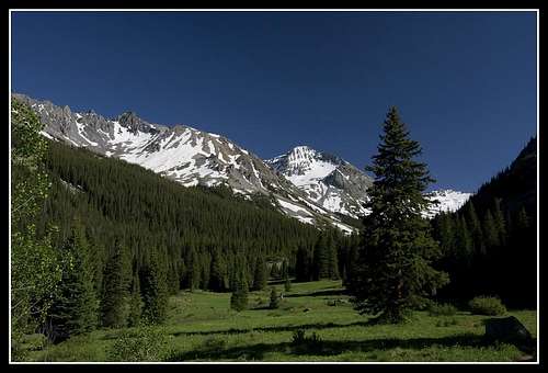
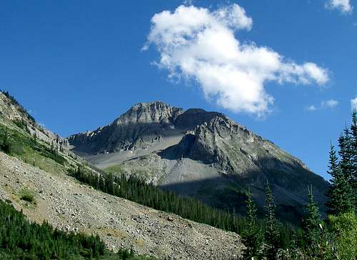
"Castleabra" is Colorado's 108th highest peak, just missing the centennial mark. This class-2 peak is often done as a pair with it's higher neighbor, Castle Peak. By mountain standards, "Castleabra" isn't hard to summit. By the Elk Mountain's standards, it is one of the easier destinations to scale in that, the generously scattered talus, scree and rotten rock is manageable. But like with most mountains in the Elk Range, nothing here is to be trusted.
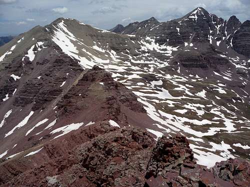
It is true that Castle Peak and Conundrum Peak get hiked and scrambled far more than "Castleabra." However, the views from this summit of the better known peaks (and I mean Fourteeners), are pretty good and not often seen. "Castleabra" lies deep within the Maroon Bells-Snowmass WIlderness Area. What this means, is that people will not have the displeasure of hearing or seeing vehicles (4x4 or otherwise), traffic, infrastructure or anything motorized or mechanical. Even drones are prohibited. This is true wilderness for all who wish to experience it.
"Castleabra" was named as an ode to it's fourteen-thousand foot neighbor. Castle Peak was named during one of the four historical Hayden Surveys during the mid-1870's because of the many spires and columns along its ridges...resembling a European castle. "Castleabra" was later named in association to this by later miners.
A minor note, any peak, mountain, point or gepgraphic feature that has its name in quotation marks is considered unofficial. "Castleabra's" official name, at least according to the USGS is Point 13,804'. This elevation is updated to account for the recent LIDAR measurements.
MAPS:
USFS- White River National Forest, Gunnison National Forest
Trails Illustrated- #128 (Maroon Bells, Redstone, Marble)
Aspen Ranger District: 970.925.3445
|
Quadrangle: Maroon Bells County: Gunnison & Pitkin Prominance: 416' (map- 423') |
YDS: class-2 Prominance Rank: 2428' Gunnison & White River National Forests Maroon Bells/Snowmass WIlderness
|
Getting There
There are several approaches to reaching "Castleabra". I'll briefly explain the details about three of the approaches/getting there: Montezuma Basin from the east, Conundrum Creek from the north which also access Conundrum Hot Springs and Cumberland Basin to the south. Each approach has its advantages and each is very different from the other. Sometimes in getting to the mountain, the approach alone is worth of a trip!
Montezuma Basin
This is a popular trail for camping, hiking, and off-road driving, but you can still enjoy some solitude during quieter times of day.
From the town of Aspen, drive west on Co. 82 to the roundabout marking Ashcroft and Castle Creek Road. Follow Castle Creek Road (paved) south to the ghost town of Ashcroft. This is about 11-12 miles. Drive past Ashcroft and after ~2 miles, turn west onto a dirt road, Forest Road #102 (This is also marked as Pearl Pass Road I believe). There are camping sites and pull-outs for passanger cars along the first half mile. After this, the road will get noticeably rougher and steeper. Four wheel drive vehicles can continue further.
After 2.6 miles, an unmarked junction comes into play around 11,130'. Last time I checked, there was a decripit, wooden sign marking this junction with "Pearl Pass" and "Montezuma Mine" scripted on the sign. Chances are good the sign is no longer there. There is additional but limited parking at this junction. Stay to the right, cross the bridge over the falls and turn onto Montezuma Mine Road and follow this rough Jeep road to its terminus to a flat but equally rough area just past the mine at 12,840'. This is the trailhead (upper). The left hand road at this junction leads up and over the infamously rough Pearl Pass (FR #129). In winter, Castle Creek Road is plowed and open to Ashcroft but this approach is rife with avalanche paths and upper Montezuma Basin is a notorious 'terrain trap'. Be advised. All told, this approach is about 4.5 miles one-way and takes in about ~2,835' of gain.
Conundrum Creek
This is a very popular area for backpacking, camping, and hiking, so you'll likely encounter other people while exploring. The best times to visit this trail are late June through mid-October. But leave the doggos at home — dogs aren't allowed on this trail.
From the town of Aspen, head northeast onto CO. 82 to the large roundabout and proceed south onto Castle Creek Road (Cty Rd. 15). Drive south for about 5 miles then turn right onto a paved road. Descend and cross over Castle Creek then take the first left after .3 miles (FR 128) at a 'T' junction. Drive southwest along this road for about 6 miles. There is a ton of private property in the area. So be advised. This is only about a ~15 minute drive.
In winter, this road is open to within .5 mile of the actual trailhead. On occasion (light snow years or early season), the plows will continue all the way to the trailhead but don't expect it. This trailhead is at 8,800'.
In summer, this is a LONG approach, something to the tune of 9 miles one-way and about 2,800' of elevation gain. In winter, the canyon is rife with avalanche paths. Most people will camp below the hot springs in the 18 semi-dispersed areas.
From the parking lot, follow the trail as it climbs out of the valley to snake over rolling grassy hills, through dense evergreen forests, and across short scattered scree fields and wide open expanses. Expect three noticeable creek crossings: the first at 2.5 miles, the second at six miles across a bridge and the third at 6.5 miles, which requires a ford straight through the creek. A final short, rocky ascent brings you to the pools overlooking Conundrum Creek Valley.
If the limited, free parking lot is full, return to Castle Creek Road where overflow parking is available. Avoid parking on Conundrum Road where parking is prohibited and cars can be towed. The trailhead is visible at the edge of the parking lot at the end of Conundrum Road. The views along Conundrum Creek are superb. Even before you reach the steaming waters of Conundrum Hot Springs, thick, shady groves of towering Aspen’s give way to sprawling grassy meadows of wildflowers.
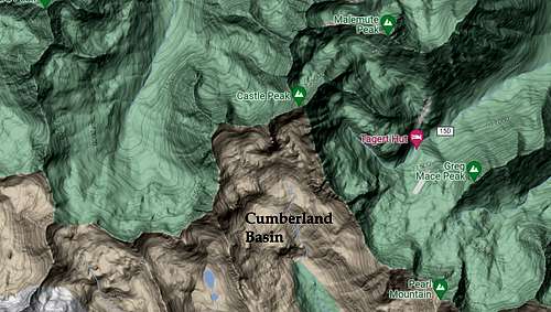
Cumberland Basin

For those truly wanting a backcountry, wilderness experience where the trail is merely a suggestion, Cumberland Basin to the south is the answer.
Starting from the intersection of highway #135 & #738 just south of Crested Butte, follow county road #738 for a total of 12.8 miles to the Cumberland Basin Trailhead.
You will pass the Brush Creek/Crested Butte airport and Brush Creek Trailhead along the way as #738 veers northeast and eventually north on a good 2WD dirt road. The Brush Creek Trailhead is 6.2 miles from the intersection with hwy. 135.
Continue north for an additional 6.6 miles to an unofficial trailhead for Cumberland Basin on the left. The road degrades slightly but should be no problem for a stock truck or Jeep. It's easy to miss, so drive slow.
Cumberland Basin Trail (#579) starts off heading north up the valley paralleling Middle Brush Creek. The primitive trail stays to the ast of the creek and meanders through the willows until it disappears completely in the upper basin.
The entire ridge bordering the basin to the north is usually referred to as, The Ridge of Gendarmes and extendes from Point 13,550' to Castle Peak to the east.
Red Tape
"Castleabra" lies in the Maroon Bells/Snowmass Wilderness Area. Regulations are strict and prohibitive. But in general, here are a few guidelines and rules for visits to our Wilderness areas:
![]()
- Plan ahead & prepare
- Minimize & follow current campfire restrictions and impacts
- Dispose of waste properly
- No fireworks
- Respect Wildlife
- Be considerate of other & future visitors
- Firearms (certain restrictions apply).
- Pets are not permitted in Wilderness
- Of course, leave no trace and pack out all trash.
Below are some general safety tips for making your trip to a national forest or grassland a memorable experience:
- Travel with a companion. You don't want to be by yourself in case of an emergency. Leave a copy of your itinerary with a responsible person. Include such details as the make, year, and license plate of your car, the equipment you're bringing, the weather you've anticipated, and when you plan to return. If you'll be entering a remote area, your group should have a minimum of four people; this way, if one is hurt, another can stay with the victim while two go for help. If you'll be going into an area that is unfamiliar to you, take along someone who knows the area or at least speak with those who do before you set out. If an area is closed, do not go there. Know ahead of time the location of the nearest telephone or ranger station in case an emergency does occur on your trip.
- Be in good physical condition. Set a comfortable pace as you hike. A group trip should be designed for the weakest member of the group. If you have any medical conditions, discuss your plans with your health care provider and get approval before departing. Make sure you have the skills you need for your camping or hiking adventure. You may need to know how to read a compass, erect a temporary shelter, or give first aid. Practice your skills in advance. If your trip will be strenuous, get into good physical condition before setting out. If you plan to climb or travel to high altitudes, make plans for proper acclimatization to the altitude.
- Think about your footing while traveling near cliffs. Trees and bushes can't always be trusted to hold you. Stay on developed trails or dry, solid rock areas with good footing.
- Wear appropriate clothing for the trail conditions and season
- Learn basic first aid so you will know how to identify and treat injuries and illnesses. Carry a first aid kit with you. Learn how to identify the symptoms of heat exhaustion, heat stroke, hypothermia, and dehydration, and know how to treat them.
- Make camp before dark. Traveling after darkness has resulted in many accidents from falls, so travel only during daylight. Set up camp well away from the edge of cliffs, and learn the terrain during daylight. If you have to leave camp after dark, stay in areas you have seen in daylight, go with a friend, and always use a good flashlight.
- Be alert for slippery areas and take your time to avoid tripping. Low-hanging branches and variable terrains make running unsafe, and leaves can hide slippery areas underneath.
- Alcohol and cliffs don't mix! If you drink, stay away from the cliffs. Judgment, agility, and balance are all reduced by alcohol consumption.
- Think before you drink! No matter how clean or pure stream water looks, it's likely to contain water-borne parasites and microorganisms that can cause discomfort and sometimes serious illness. Pack your water in, or purify through chemical treatment.
Camping
Cement Creek Campground- Located within 16 miles of Crested Butte, Cement Creek CG lies within the Gunnison National Forest. This area oddly, receives relitively few visitors. Which is kind of odd considering: fishing, off-roading, hiking, mountain biking and ATV can be had here.
The campground is $16 per night or $4 for day-use. There are 13 sites and reservations are not required, first come, first serve; as are many national forest campgrounds. There are two vault toilets but no water. The Forest Service operates this campground from early June to late September (approximate).
Drive 7.5 miles southeast on 135 to Cement Creek Road (FSR 740). Turn left and follow for another 4 miles to the camping area. This is a good option for a southern approach via Cumberland Basin.
Montezuma Basin- Not a formal campground per se, the end of forest service road 102 brings you to a high perch/rocky plateau at 12,800'. This small area is as high as one can get by vehicle. It is littered with small rocks, some small clearings, cold at night but with absolutely stellar views.
Castle Creek Road to the north starts off as paved, switches to hardpack dirt at 12.5 miles and gets progressively rougher whereby, at the junction for Pearl Pass, even stock trucks & Jeeps will have a tough time at it. From Pearl Pass, Montezuma Basin is only another .7 miles.
Using this northern approach, you also have the option of doing Castle Peak and for motivated folks, Conundrum Peak as well. In case driving all the way to the end of the road isn't in the plans, there are some spots along upper Castle Creek Road that provide dispursed camping. But you'll have to look for them. They are few in between.
Conundrum Hot Springs- This special place is located at 11,180' deep in the Maroon Bells-Snowmass Wilderness. It has recently seen a flurrly of protective measures put in place by the forest service to prevent further damage by overuse and thoughtless hikers/campers.
Even though most people hike the 8.4 miles to the hot springs only, camping here is decent (some sites) and provides access to "Castleabra's" north side. You will gain roughly 2,400' to the hot springs/camping area in that distance.
There is a permit system in place, mostly for the hot springs but obviously, the camping is part of that. Campfires and dogs are NOT ALLOWED. This is the backcountry. So don't expect toilets or picnic tables. Bury human waste or pack it out. Permit fees are $6.00.
Compared to most National Forest camping area's, this fee is nothig. Please be respective of these senstive places. The Conundrum Hot Springs is an extremely popular and busy place in the summer. Oh, and black bears are present. Remember that when camping.
External Link

Trip Report: Conundrum Creek Epic by: SarahT
14ers.com TREASURE TROVE OF BETA

Topographic Map