
|
|
Mountain/Rock |
|---|---|
|
|
38.45764°N / 119.81541°W |
|
|
Alpine |
|
|
Hiking |
|
|
Spring, Summer, Fall |
|
|
9942 ft / 3030 m |
|
|
Overview
Located within the Carson Iceberg Wilderness, Airola Peak's distinctive pyramid shape rises dramatically along the ridge separating Arnot and Highland Creeks. The peak is often climbed in conjunction with nearby Hiram, Folger and Iceberg Peaks. Views from the summit are good, if not quite as dramatic as other Sierra Peaks. The vista encompasses Desolation and Mokleumne Wilderness to the north, Dardnelles Cone to the southwest, Stanislaus and Sonora Peaks to the south and Highland Peak to the East.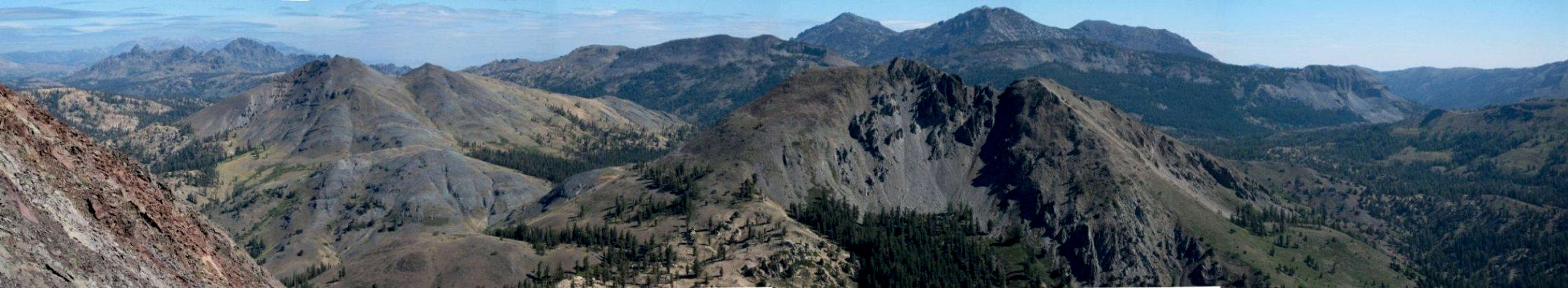  |
The peak itself is completely hidden from view at Highland Lakes, but standing just shy of 10,000 feet its presence is unmistakable within a short hike around Hiram Peak.
Airola Peak is composed primarily of volcanic rock like many of the other peaks in the region. Due to erosion over millions of years the rock can be very unstable with much scree and talus.
Most of the approach to the peak is along light use trails and much class 2 cross country travel.
 Airola from the use trail.
However, there is one section along the north ridge that requires some very easy class 3 climbing. If not for the unstable rock composition of this portion, a class 3 rating would be a stretch.
 Class 3 section on the north ridge.
Getting There
The HighwayAirola peak is located several miles off of CA Hwy 4. About 16 miles east of Bear Valley and 1.5 miles west of Ebbets Pass turn onto Highland Lakes Road (FS 8N01). Proceed 5.5 miles. The last 3-4 miles are unpaved but passable by passenger cars.
The Hiking
To reach Airola, one can follow at least two different approach routes both of which end at the foot of the north ridge of the peak:
1. Follow a faint use trail that begins from the parking area at the western end of Highland Lakes. The trail starts along the south side of Highland Creek (opposite from the main trail). This route contours along the northern flank of Hiram Peak, ultimately dumping the climber at the foot of the north ridge. Approx 2.25 miles one way and 1,300 feet of elevation gain.
2. From the summit of Hiram Peak descent the west face and descend to the wooded saddle between the peaks. Approx 3 miles one way and 1,000 foot gain to Hiram and another 1,200 feet from the saddle.
The north ridge is very easy to follow and good views of the peak and surrounding landscape can be seen. At about the midway point along this ridge a short class 3 section must be passes. The climbing is quite easy but the lousy quality of the rock may give some pause.
Red Tape
Airola Peak lies within the Carson Iceberg Wilderness Area. Permits are not required for day hiking, but they are for overnight visits. Permits can be obtained at the following Ranger District offices.Calaveras Ranger District
P.O. Box 500
(Highway 4)
Hathaway Pines, CA 95233
(209) 795-1381
FAX (209) 795-6849
TDD (209) 795-2854
Stanislaus National Forest
19777 Greenley Road
Sonora, CA 95370
(209) 532-3671
FAX (209) 533-1890
TDD (209) 533-0765
More information can be found at the forest service website.
Camping
There are numerous developed campgrounds in the vicinity.Highland Lakes Campground
Bloomfield Campground
Hermit Valley Campground
Dispersed camping is also available with appropriate overnight permits. Information can be found on the Forest Service website.
Etymology
"John and Emma Airola homesteaded 160 acres near Frogtown in the 1890s. The family has been in the cattle business since 1909 (Browning 1986)"Erwin G. Gudde, California Place Names