-
 111039 Hits
-
 97.08% Score
-
 65 Votes
|
|
Mountain/Rock |
|---|---|
|
|
49.66222°N / 125.747°W |
|
|
Mountaineering |
|
|
7208 ft / 2197 m |
|
|
Overview and History
 The Golden Hinde from the North Ridge of Mt Burman The Golden Hinde from the North Ridge of Mt Burman |
The Hinde lies roughly in the centre of Strathcona Provincial Park between the Wolf and Burman River watersheds, far from the nearest road in any direction. An approach to and ascent of the mountain from any direction is, therefore, a committing 4-7 day trip involving some engineered trail but a lot more rough boot-path, steep bush, snow and ice on the approach and technical, sometimes loose, basalt rock on the mountain itself.

Original 1937 survey marker
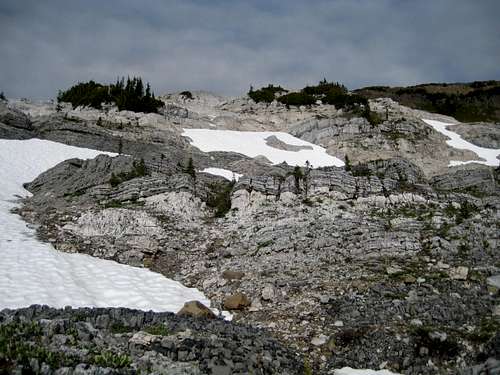
The geology of Vancouver Island is hugely complex and nowhere more so than on the southern and especially eastern approaches to the Golden Hinde. About 130 million years ago, the seabed south of the equator slid north and collided with the west coast of North America. The buckling process that followed thrust up areas of the sea floor that ultimately became Vancouver Island, the Queen Charlotte Islands and part of the Alaska Panhandle. The seabed is still there today, complete with its marine fossils, in the form of incredible and incongruous limestone strata. Sometimes these will be found as contiguous areas, such as the “Limestone Cap” on the eastern approach and sometimes embedded between layers of granite. It’s often hard to grasp the reality of what you’re looking at. The experience certainly brings home the fact that humanity and all its works are but a blip in the history of the planet.
The first ascent of the Hinde took place on an un-recorded day in 1913 or 1914 by E. Anderson and W.R. Kent during the course of the initial survey of Strathcona Park. The mountain received its second ascent the next day when W. W. Urquart, Kent’s survey partner, insisted that Anderson take him up as well. It wasn’t until the N.C. Stewart re-survey of 1934-38 that the mountain received its third and subsequent ascents. Stewart’s 1937 brass survey marker is still on the summit, although it is confusingly labelled “27”.
The mountain was initially known as the “Rooster’s Comb” as a result of its silhouette from the northeast or southwest. By 1939 it was well recognized that the mountain was the highest on the Island and a Captain R.P. Bishop decided that it should enjoy a grander title rather than one with barnyard connotations. He suggested the Golden Hinde after concluding that Sir Francis Drake had seen Vancouver Island during his voyage of 1579 from his flagship of the same name. Stewart agreed and together they convinced the Geographic Board of BC to accept the new official name.
The Golden Hinde did not receive its first winter ascent until 1993 when P. Stone, C. Barner and R. Slieker climbed the SE Gullies route directly from the Wolf River Valley.
Getting There
Vancouver Island can be reached by air from Toronto, Vancouver, Seattle, Calgary and Edmonton to Victoria, Nanaimo, Comox or Campbell River and by ferry from Port Angeles to Victoria on The Coho and on BC Ferries from Vancouver to Victoria or Nanaimo. Public transport on the Island is notoriously poor and anyone arriving by air would be advised to rent a car.The Hinde can be approached from three directions: the north, south and east, each with their own sub-variations. No one I know seems to go exactly the same way and argument rages over the best choices. The routes can even be interconnected, allowing the climber to approach from one direction and leave by another.
Initial access in all cases involves driving only on paved roads, so a normal 2WD sedan is fine.
Approaches
Approach from the south.
Considered by many to be the easiest and quickest approach.
From Campbell River, at the end of the freeway section of the Inland Island Highway 19, take highway 28 west towards Gold River. After approximately 30km the road meets Upper Campbell Lake with the first views over the mountains and after 47km you will enter Strathcona Park at Elk Portal. Exactly 1km further on highway 28 makes a right turn over the bridge at Buttle Narrows. Ignore the turn and carry straight on down the paved Buttle Lake Parkway (also known as Westmin Mine Road). This runs south down the east shore the whole length of the lake and offers ever improving views. About 39km south of the Buttle Narrows bridge, the road swings west over a bridge around the end of the lake. Pass the gravelled Jim Mitchell Lake Rd on the left, drive 6km up the hill, through the Westmin mine site and into the BC Parks parking lot on the far (west) side of the mine.
From the parking lot walk 50 metres SW on the gated gravel road that accesses the Westmin Mine powerhouse to the trailhead signed for Phillips Ridge/Arnica Lake. Follow the well-engineered and contoured trail up to Arnica Lake in 3-5 hours. There are tent platforms and an outhouse at the north end of the lake. However, this tends to be a very buggy area and you might want to push on for another hour or so, to get higher and into some breezes on Phillips Ridge above.
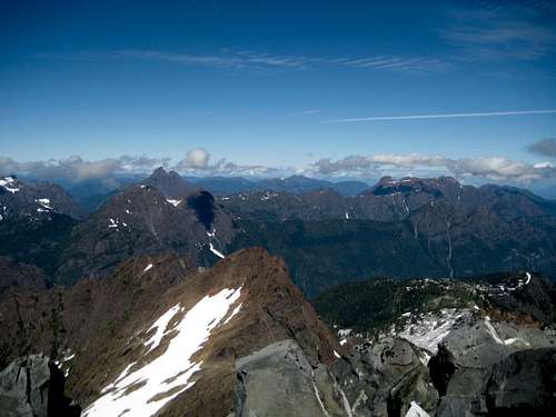
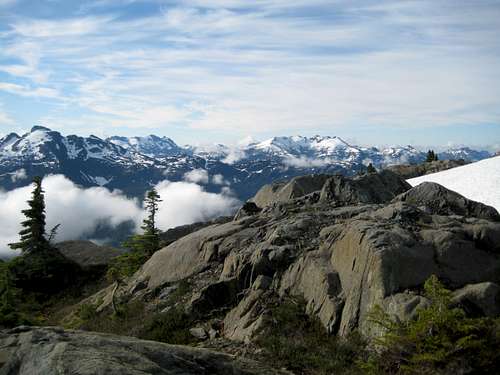 Peaks to the south of lower Phillips Ridge | 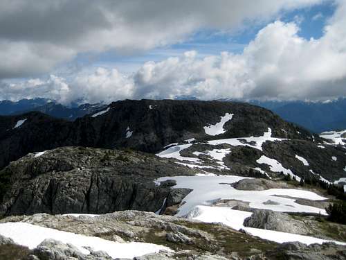 Peak 1732 | 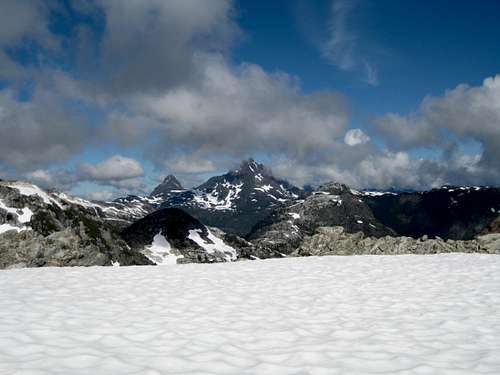 The Golden Hinde from Phillips Ridge |
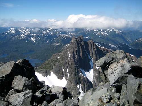
 View N approaching the low point of Phillips Ridge | 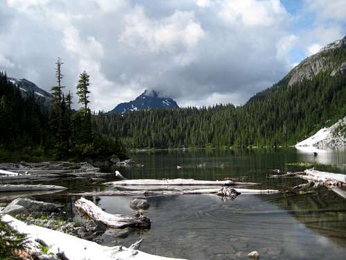 The Golden Hinde from Carter Lake | 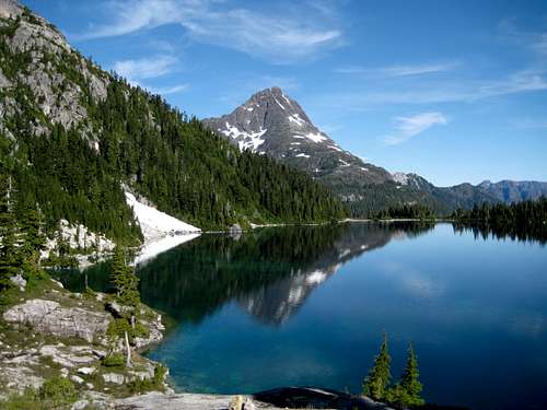 The Golden Hinde from Schjelderup Lake |
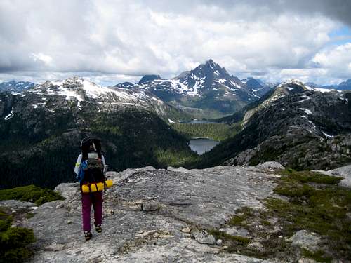
Option 1. From the low point on Phillips Ridge at GR 520991 descend a steep gully to the unnamed river flowing out of Carter Lake and up to the lake on a flagged, bushy route. Then along the west shore of Carter, over the drainage divide between Carter and Schjelderup Lakes and along the west shore of Schjelderup to its outflow. Excellent trail ascends a bench under the north ridge of Mt Burman and puts one on this ridge below some obvious bluffs. From this point, or indeed from Schjelderup Lake itself, the Hinde can be summited as a day trip with light packs. The option to proceed towards the mountain to further shorten summit day certainly exists.
Continuing with the approach (with full or light packs); descend the north ridge of Mt Burman all the way down to the head of Burman Lake at 1150 metres. The last 50 vertical metres are very steep, part of it down a tree root “ladder”. This is the ill-conceived “BC Hydro chasm” another of the mad insults that government and industry have foisted on this delicate area over the decades. This one was designed to re-direct the outflow of Burman Lake down the Wolf River Valley to the north and feed a hydro plant on Upper Campbell Lake. Fortunately, it was nipped in the bud before it got going. You can still see some heavy cable used in the construction in the deep cleft between the Hinde’s lower south ridge and the north ridge of Mt Burman. Needless to say, this deep, moist chasm provides a fertile breeding ground for millions of mosquitoes. You’ll want to move as quickly as you can through the area.
Climb out of the chasm onto the lower south ridge of the Golden Hinde and up to the south bowl below the south face. You’ve now joined the northern approach. The climbing routes are generally considered to start from the south bowl.
Option 2. From the low point on Phillips Ridge noted above climb the next bump on the ridge and look for a series of interconnecting snowfields that lead down to the head of Schjelderup Lake. Go down these snow ramps. Some steep forest must be descended after the snow runs out and, of course, there will be seasonal variation in this route. At the head of Schjelderup you’ve joined the first option.
Option 3. Proceed even further along Phillips Ridge, over two more bumps and almost to the junction with Greig Ridge at the bump known locally as Mt Judy. Drop 450 metres directly down to the outflow of Schjelderup Lake. The route is flagged/cairned but, as always, there are choices to be made in the fine details and I have heard of parties having to rappel sections of this route. Join the other options at the outflow of Schjelderup.
 Descent Option 1 Descent Option 1 |  Descent Options 2 & 3 Descent Options 2 & 3 |  Descent Options 1, 2 & 3 Descent Options 1, 2 & 3 |
Refer to the photos above for clarification of the three options.
Approach from the north
From Campbell River, at the end of the Island Highway 19, take highway 28 west towards Gold River as described for the south approach. At the Buttle Lake bridge make a right turn in the direction of Gold River. Drive approximately 20km passing the Kings Peak (left) and Crest Mountain (right) trailheads before arriving at the Elk River Trail (ERT) on the left.
The ERT is in the fee-required core area of Strathcona and, depending on placement of your first camp, money might be due for the first night. Refer to this map for clarification.
Proceed south initially on the well-engineered trail past the exit points for Elkhorn Mountain and Mt Colonel Foster and, eventually up to Elk Pass, between Rambler Peak and the Colonel. Long before reaching the pass – just after the turn-off for Landslide Lake – the way has degraded into a marked route. After crossing Elk Pass you can see the Hinde in the far distance.
Proceed south initially on the well-engineered trail past the exit points for Elkhorn Mountain and Mt Colonel Foster and, eventually up to Elk Pass, between Rambler Peak and the Colonel. Long before reaching the pass – just after the turn-off for Landslide Lake – the way has degraded into a marked route. After crossing Elk Pass you can see the Hinde in the far distance.
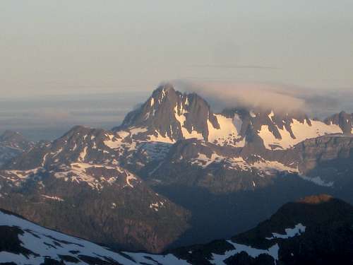
 Elk Pass | 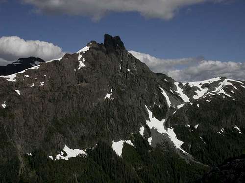 The Behinde |
As may be obvious from the foregoing, self-sufficiency, wilderness navigation and route finding skills need to be well to the fore on this and, indeed, any approach to the Golden Hinde.
Approach from the east.
You need a canoe or kayak for this one. Proceed as described above for the south approach. 21 Km after passing the turn-off for Gold River, park at the Augerpoint day use area. Cross the lake to the outlet of Phillips Creek, where there is a marine camp site with facilities. Avoid a late afternoon crossing when winds funnelling up the valley can make the lake very rough.
From Phillips Creek, Parks’ excellent, switchback trail takes you in about 4 hours up to Marble Meadows. The name says it all about this beautiful but delicate area. Tread carefully amongst the flowers!
Good trail leads west across the meadows south of Marble Peak in 1-2 hours to the A-frame Wheaton Hut – the only such hut in Strathcona Park – with Wheaton Lake nearby. Most parties camp here the first night.
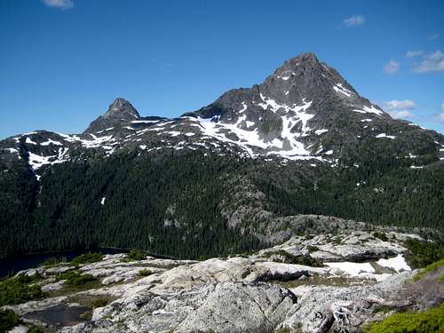
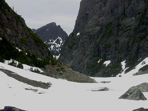
 Head of Marblerock Creek | 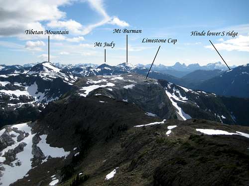 Hinde E Approach from Morrison Spire | 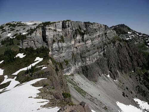 Limestone Cap | 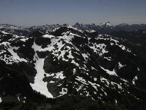 Crystal Mountain from Tibetan Mountain |
Ascend on the left of the crest aiming for the waterfall coming off the ridge that connects Morrison Spire and Mt McBride. Climb up to the ridge on the right of the waterfall on snow or loose rock and then angle south to Morrison Spire. The Spire is easily ascended as a side trip if desired.
Once you are on the ridge crest the Hinde is in continuous and awe-inspiring view.
From Morrison Spire the route heads generally south over several bumps before reaching its junction with Greig Ridge. There is good camping in the saddle between the 1800 and 1720 metre bumps, known locally as Tibetan Mountain and Crystal Mountain, before reaching Greig Ridge – consult the 1: 50 000 topo. Most parties camp here on the second night.
From the second camp proceed south and then west before arriving at the summit of “Mt Judy” the highest bump above Schjelderup Lake on Phillips Ridge. This is option 3 of the descent points from Phillips Ridge described in the south approach above. Descend to the lake and join the other routes at the outflow.
  |
Overview of Summit Routes
The SE Gullies; 4th Class, 250 metres. The standard route up the HindeThe South Face; 5.4, 300 metres, 5 pitches
The West Ridge; 4th Class, 500 metres
The West Face; 4th Class, 300 metres
The Northwest Ridge; 4th Class, 400 metres
The North Ridge; up to 5.9, 300 metres
Refer to the Island Alpine guidebook – see “Suggested Reading” below.
Red tape, safety and other considerations
There is a $5/person/night fee for camping in the so-called core areas of Strathcona Park, of which the Elk River Trail is one. You’ll likely not get anything for your money but you’ll have to stump up anyway if you’re planning on camping anywhere north of the Landslide Lake turn off on the northern approach. There are no formalities required on either of the other two approaches.Be aware that BC Parks does not operate an intentions system. Make sure, therefore, that you have left a detailed trip plan with someone responsible. The RCMP and the appropriate SAR agency will respond in an emergency but it is up to you to have the mechanism in place that will initiate the call-out process if it becomes necessary.
There is line-of-sight from the summit of the Hinde to the cellular repeater tower on the summit of Mt Washington and, therefore, full service from there. There is no service anywhere else on any of the approaches or sub-summits described above.
Camping
Anywhere you like. The only formality you may run in to is the need to pay a fee if choosing to camp in the vicinity of the ERT – see Red Tape above.Fires are strictly prohibited, so you must pack a stove. Bear and cougar frequent the mountains and forests of Vancouver Island, so proper back country methods – hanging food bags out of reach, cleaning up all cooking scraps, good toilet practice etc – are essential. Giardia is well documented throughout Strathcona Park, so boil or treat all water.
Weather
Nearest point forecastAdditional Information
Maps required for this trip are the government 1:50 000 topographical map sheets 92F/12, “Buttle Lake” (south and east approaches) and 92F/13 “Upper Campbell Lake “ (north approach). Advance copies can be ordered at BC Government Maps on-line. Copies are usually readily available in good bookstores and outdoor stores throughout the Island.Suggested Reading
Island Alpine – A Guide to The Mountains of Strathcona Park and Vancouver Island, Philip Stone, Wild Isle Publications, 2003, ISBN 0-9680766-5-3 and/or visit Island Alpine Climbing Guide
Beyond Nootka – A Historical Perspective of Vancouver Island Mountains, Lindsay Elms, Misthorn Press, 1996, ISBN 0-919537-29-4 and/or visit Beyond Nootka
Hiking Trails III A guide to the mountains and trails of northern Vancouver Island.