
-
 11334 Hits
-
 86.85% Score
-
 23 Votes
|
|
Mountain/Rock |
|---|---|
|
|
47.65244°N / 14.23862°E |
|
|
Hiking, Scrambling, Via Ferrata, Skiing |
|
|
Spring, Summer, Fall, Winter |
|
|
7835 ft / 2388 m |
|
|
Overview

On the east ridge
Seen from the east, from the very frequented Wurzeralm, Warscheneck catches ones eyes with its horizontal bands appearance. These are especially picturesque when covered with first snow, when shadows and light on these rock structures make a true graphical masterpiece.
First of all Warscheneck is a hikers mountain. On a nice day people come on its top from various sides. Some ascents, as for example from Wurzeralm, or from any of the other two supporting mountain huts, are not very long. You need to overcome less than 1000 altitude meters. But, as elsewhere in Totes Gebirge all one-day ascents from the surrounding valleys are much longer and require good endurance. Marked paths on top are mostly easy, they can also be combined in various crossings of the summit of Warscheneck. Over the steep south-east ridge also an easy ferrata reaches the top.
The whole area is very attractive also in times of tour skiing. Many notches and mountain shoulders can be the goal of a ski tour, the very summit of Warscheneck can be reached with skis from the north, from Zeller Huette.
Wurzeralm

Brunnsteiner See

On Wurzeralm
Summit Panorama
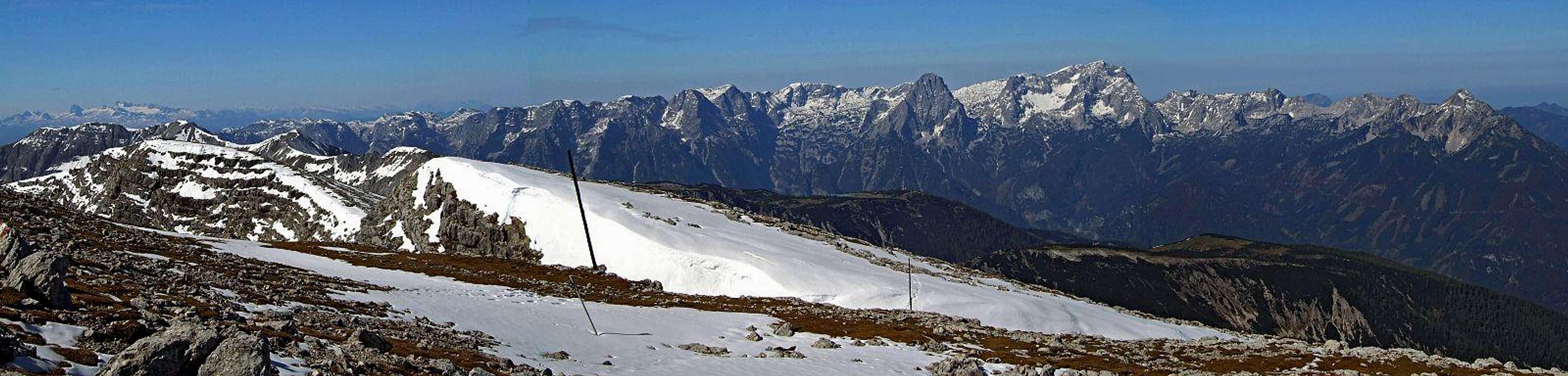
Totes Gebirge massif from the SE, from the summit of Warscheneck

Summit
Getting There
The most obvious trailhead for Warscheneck ascent is Wurzeralm. It can be reached from the road below Pyhrn Pass (on the NE side) by a special 'train cable-lift', a fast device which takes some 80 people some 600 meters higher in minutes. In summer it starts operating at 8:30 a.m. and the last drive in the valley is at 4:30 p.m. (2007). The bottom station lies by the road over Pyhrn Pass, so you exit Pyhrn highway on any side of the pass and drive up or over it. Otherwise on the southern side bigger towns are Liezen and Rotenmann, on the northern side Spittal am Pyhrn and Windischgarsten. Wurzeralm means the eastern approach.Northern approaches go from Stodertal. We start the ascent either in Hinterstoder or in Vorderstoder or in some of other places on the road, which connects Pichl (by Pyhrn highway) and Hinterstoder. All these approaches reach first one of the two mountain huts, which support ascents from the north and north-east.
South-western ascents are much longer. They come over broad karst plateaus from Liezener Huette, along the long crest, connecting Warscheneck with the rest of Totes Gebirge massif.
Map: Alpenverein-karte 15/3, Totes Gebirge Ost.
Routes Overview
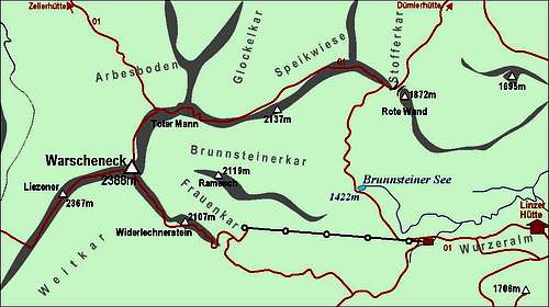
A self-made map of Warscheneck
Hikes And the Ferrata
1. From Duemlerhuette. 3h.
2. From Wurzeralm by the east ridge. 3h.
3. From Wurzeralm by the SE ridge ferrata. 3h.
4. From Wurzeralm over Windlucke and by the west ridge. 4h.
5. From Zellerhuette. 2 h 30 min.
Ski Tours
1. Through Unteres Loigstal to Windlucke. (Ascent also possible from Wurzeralm.)
2. Through Oberes Loigstal to Wetterlucke and Pyhrner Kampl. (Ascent also possible from Wurzeralm.)
3. Gasthof Schoiswohl, 680m - Zellerhuette, 1575m - Warscheneck, 2388m.
You can see a detailed map (1:50000) on-line on: http://www.austrianmap.at/.
 SE ridge SE ridge |  E ridge E ridge |  SE ferrata SE ferrata |
Mountain Huts

Linzer Haus on Wurzeralm, 1371m. Opened from mid May till end of October.
Wurzeralmhuette, 1407m. Opened from June till end of October.
Zellerhuette, 1575m. Opened from start of June till end of September. In May and October also on weekends. Ascents from Vorderstoder or Rossleithen to the hut require 2 hours.