
-
 35538 Hits
-
 76.48% Score
-
 7 Votes
|
|
Mountain/Rock |
|---|---|
|
|
40.80692°N / 121.62629°W |
|
|
Shasta |
|
|
Mixed |
|
|
Summer |
|
|
7863 ft / 2397 m |
|
|
Information on the Peak
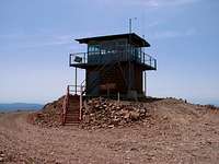
Burney Mountain at 7,863 feet is one of the most beautiful mountain peaks in Northern California. There is a road that takes you to the summit of the extinct volcano. At the summit there is a fire lookout tower that helps spot wild fires during the summer months. It was built in 1934, and rebuilt in 1960. It is still used to this day.
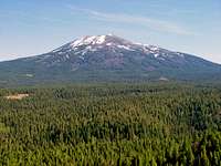
The image to the left was taken at a vista point near Tamarack Road. If you enlarge the image you can see the lookout tower, it appears to be nothing more than a tiny black dot on the mountain.
While at the summit you get awesome views of Mount Shasta to the north, Lassen Peak to the south, Black Butte, Castle Crags, Crater Peak, Soldier Mountain and many other peaks so bring you camera!
This mountain is usually ignored due to its bigger neighbor to the south, Crater Peak. At 8,677 feet it is only 814 feet taller than Burney Mountain, not that much taller at all, but people still dont give Burney Mountain a chance. They dont know what there missing when they pass up this beautiful peak!
The ride up to the summit of the mountain is one of the most scenic roads that one might ever take! The trip up is something that the whole family will enjoy and will probably never forget, it is just that great of an experience! It is one of the areas best kept secrets!!
For even more info about the mountain click on the link below.
Burney Mountain Info
How to get to the summit
From Redding take Highway 299 east for about 50 miles. Then take a right
on Tamarack Road right across the street from the Serria Pacific
enterance. This road is paved just for a little bit then turns into a
rough dirt road because logging trucks use it daily. Keep following this
road, passing Dry Lake in the process, until you find a road to the left
named Forest Route 34N19. Take this road for a few miles and then make
another left on Forest Route 34N23. Keep following this road until you
find a sign telling you that the (Burney Mountain lookout) summit road is
to the right. Follow the road and you will end up at the summit! The road
is about 7 miles long and usually takes an hour to get to the top becasue people like to stop and check out the breathtaking scenery.
*Note: The summit road requires a 4x4 vehicle!!*
The image above is the lookout tower on the summit of the mountain.
Lodging/Camping
The best place to stay at is the Shasta Pines Motel in Burney. You get a
great view of Burney Mountain and there is a nice swimming pool.
shastapinesmotel.com
You can also camp around the mountain. For info on camping go to the
Lassen National Forest website.
fs.fed.us/r5/lassen
McArthur-Burney Falls Memorial State Park
http://www.parks.ca.gov/?page_id=455
Mountain Conditions/ Webcam
A good place to go for current weather conditions is the Burney Chamber ofCommerce website.
burneychamber.com
For live pictures of Burney Mountain click on the link below
The CasselCam View of Burney Mountain
Best Months for an Ascent
The best time to go up Burney Mountain is from June to October, dependingon how much snow it got in the winter. It usually gets alot of snow in the
winter so it takes a while for it to melt off the road.