
-
 17349 Hits
-
 95.67% Score
-
 54 Votes
|
|
Mountain/Rock |
|---|---|
|
|
44.07530°N / 114.6111°W |
|
|
Custer |
|
|
Hiking, Mountaineering, Scrambling |
|
|
Summer, Fall |
|
|
11302 ft / 3445 m |
|
|
 Lonesome Peak from Antz Basin
Overview
Lonesome Peak is located in the heart of central Idaho’s White Cloud Mountains. The summit is most often viewed from “Antz Basin Divide” by hikers looking northeast as they head from Fourth of July Lake to the Born Lakes. Also, anyone who visits the Boulder Chain of Lakes will see this rugged peak standing at the far western end of the beautiful string of lakes. With an elevation of 11302’, Lonesome Peak is ranked number 68 amongst Idaho’s Highest Peaks, and is listed as the fourth tallest on the White Cloud Peak List.One of the main attributes of the White Clouds that make the range appealing to scramblers is the abundance of high and traversable ridgelines. Those who enjoy ridge walks are rewarded with numerous challenging and enjoyable traverses throughout the range. Three such ridges converge at the summit of Lonesome Peak. The shortest of the three is the west ridge, which only loses about 700’ feet at the first half-mile from the summit, but then plummets quickly thereafter into the Warm Springs Creek drainage. The northeast ridge is the most complex of the three, with no recorded ascents. It drops briefly to a 10400’ col before tying into a large c-shaped crest, which is home to six other eleven thousand foot peaks and encircles the Big Boulder Lakes. The south ridge is also very impressive, and is home to the “Devil’s Staircase”. The staircase is a steep chute, full of loose rock, used by many hikers to connect the Born Lakes with Windy Devil Pass. Those who choose to traverse the south ridge from Devil’s Staircase to the summit will experience a long ridgewalk, with an abundance of boulder hopping.
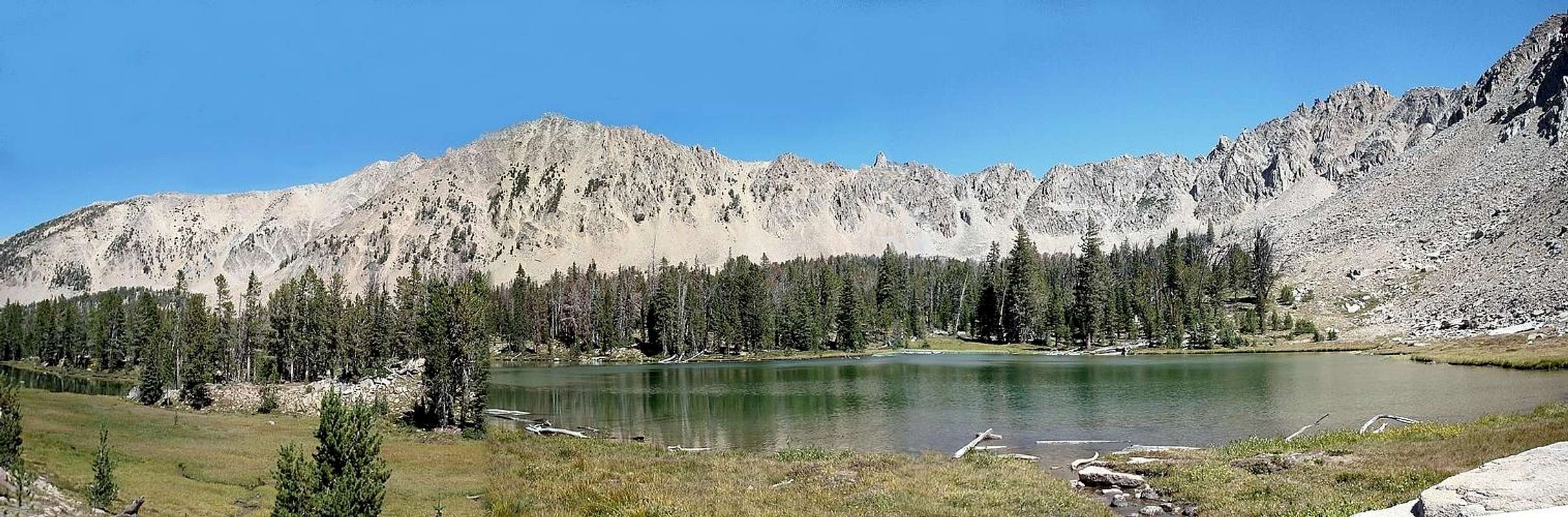  |
 Lonesome Lake
The unofficially name “Lonesome Peak” was applied by Rick Baugher, who made the first recorded ascent on October 10, 1999. The name “Lonesome Lake Peak” has also been used. The peak is indeed lonesome, with very few people venturing to its summit. But probably the main reason behind this title is that the peak forms a rugged backdrop to Lonesome Lake, which is the highest of the Boulder Chain of Lakes, and is the second highest lake in all of Idaho, with an elevation of 10435’. The rock-lined lake may not be very hospitable, but it is quite beautiful when viewed from the summit of its namesake “Lonesome Peak”.
Summit Views
With a lofty elevation and a central location within the White Clouds, the summit of Lonesome Peak is a commanding position for viewing the rest of the range. All seven of the other White Cloud 11ers are visible (Castle, Caulkens, David O Lee, Peak 11272’, WCP-9, Peak 11202’, & WCP-10). Looking down the Boulder Chain of Lakes located to the east of Lonesome Peak is a definite highlight. And it’s also a great vantage point to check out Antz Basin, Blackman Peak, and Patterson Peak. Northern White Cloud 11ers Northern White Cloud 11ers |
 Boulder Chain of Lakes Boulder Chain of Lakes |
 Castle Peak & Serrate Ridge Castle Peak & Serrate Ridge |
Getting There
 Boulder Chain View
 South Ridge
 Lonesome Routes
 Antz Basin View
 View of West Ridge
 Southwest Face
The most likely starting point for a climb of Lonesome Peak is at the Fourth of July Creek trailhead. This is the most popular trailhead in the White Clouds because it gives access to many scenic destinations including Fourth of July Lake, Born Lakes, and Four Lakes Basin. It is also the starting point for scrambles of several nearby peaks such as Blackman Peak, Patterson Peak, and Fourth of July Peak to name a few.
Another option for reaching Lonesome Peak is to do a multi-day trip into the Boulder Chain Lakes starting at the Livingston Mill trailhead on the East Fork of the Salmon River. However, the descriptions below only apply to the Fourth of July Creek approaches.
The Drive
To reach the Fourth of July Creek trailhead, follow Highway 75 about 17 miles south from Stanley (or 45 miles north from Ketchum), then head east on the gravel Fourth of July Creek Road. Continue 10 miles up the road to the trailhead. There you’ll find a good-sized parking lot and an outhouse. The road is pretty rough and wash-boarded, but high clearance isn’t required.Approach(s)
Most of the routes on Lonesome Peak can be accessed from the Forth of July trailhead. Whatever route is chosen, you must first make your way to Born Lakes. The most common option to get there is to head up the trail to Fourth of July Lake, turn on the trail that heads north up and over the divide to Antz Basin (formerly “Ants Basin”), then continue east to the Born Lakes.An alternative route to Born Lakes is to climb Blackman Peak along the way (see Blackman’s southwest ridge route page for specifics). From the summit of Blackman Peak, descend the peak’s east ridge off of the summit block, then drop down to Antz Basin, and pick up the trail leading to Born Lakes. This is about a half-mile shorter distance than the trail option, but with about 400 feet more elevation gain. You’ll be rewarded with some awesome views.
Route Overview
Below are a few route suggestions for Lonesome Peak. Additional ones could probably be devised as needed, but these are the most obvious choices. It is highly recommended to make a loop out the climb by returning to the trailhead using a different route from the one that brought you in. This would allow you to sample even more of the fantastic White Cloud scenery.| Route | Description | Trailhead (Topozone Link) |
Mileage (One Way) |
Difficulty |
| Southwest Face | Ascend one of the gullies southwest of the summit until gaining the west ridge a couple hundred feet below the highpoint. | Fourth of July | 5.0 | Class 2/3 |
| South Ridge | Gain the ridge using Devil's Staircase, then make the boulder hopping traverse to the summit. Great views in both directions. | Fourth of July | 5.2 | Class 3 |
| West Ridge | The least technically challenging route, but the longest approach of the Fourth of July options. | Fourth of July | 5.3 | Class 2 |
| East Ridge | Make base camp at one of the Boulder Chain Lakes, then scramble to the summit via Lonesome Lake. | Livingston Mill | 11.2 | Class 3 |
Camping
 Scoop Lake
 The sun setting on Lonesome Peak.
 Hummock Lake
Camping at the Fourth of July Creek trailhead is a possibility, but there isn’t a ton of space, and no improved camping is available (i.e. no picnic tables, fire rings, etc). There are a few campgrounds across Highway 75, with the closest being at Petit Lake or Alturas Lake. Accommodations are available in Stanley, or closer to the trailhead at the Smiley Creek Lodge.
If you enjoy backpacking, then campsite options are plentiful on the approaches to Lonesome Peak. You can’t go wrong at Fourth of July Lake or one of the Born Lakes if starting at Fourth of July Creek. Choices abound in the Boulder Chain of Lakes as well, with great campsites at Hummock Lake or Scoop Lake near the to of the string, or at Hatchet Lake down towards the bottom. Those definitely aren’t the only options, just a few of the best ones.
Red Tape
No permits, parking passes, or any other kind or red tape to worry about. Just tread lightly and respect the fragile nature of the local ecosystem.When to Climb
The summer climbing season in the White Clouds is typically from July until the snow flies in October. Climbing Lonesome Peak earlier in the year is certainly feasible, but the approach could be much longer depending on how early the road to the trailhead melts out. The best time for a visit is probably late mid July, after the snow has melted and when the wildflowers are most abundant.Mountain Conditions
- Sawtooth National Forest - NF Current Conditions.
- NOAA Pinpoint Forecast – Weather.
- Idaho Outdoors Forum – Message board monitored by many local climbers.
Guidebooks
There are no route descriptions available in print for Lonesome Peak that I am aware of, but the following to guidebooks are full of information about the White Clouds.
 | Idaho: A Climbing Guide by Tom Lopez – This is far and away the premier mountaineering text for the state, with an entire section devoted to the White Clouds (maybe we’ll see Lonesome Peak included in the next edition. |
 | Trails of the Sawtooth and White Cloud Mountains by Margaret Fuller – Detailed descriptions of hikes in the White Clouds and neighboring Sawtooths. Includes approach information on how to get to Born Lakes and other nearby destinations. |
External Links
- MountainVisions.Com - Check out the “Ants Basin Divide” Pano for a good view of Lonesome Peak.
- Dave’s Hiking Page - Trip Report.
- ClimbingIdaho.Com - Click the “Lonesome Peak” link to see a big batch of photos.
- Peakbagger.com - Has mostly correct information, other that the elevation value (confused with nearby Peak 11202’).