
-
 25183 Hits
-
 95.67% Score
-
 54 Votes
|
|
Mountain/Rock |
|---|---|
|
|
37.73047°N / 119.57369°W |
|
|
Hiking |
|
|
Spring, Summer, Fall, Winter |
|
|
7214 ft / 2199 m |
|
|
Overview
| "… in the spring of 1903, Mr. Roosevelt boarded a train for a trip out West … where he ditched the press to go tramping like a boy through Yellowstone … where he hiked in Yosemite with John Muir and woke up atop Glacier Point delighted that their camp was covered with snow … where he demanded that the townspeople in Santa Cruz take those stupid advertising posters off a stately redwood tree and keep California's beauty unmarred by the folly of man." |
| – Jim DiPeso, Policy Director for Republicans for Environmental Protection during a keynote speech at the 21st annual "Public Interest Environmental Law" conference in Eugene, Oregon; March 6, 2003 |
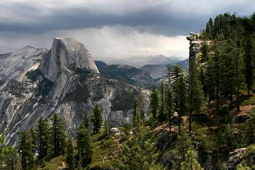
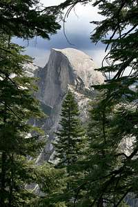
Glacier Point in Yosemite National Park is perhaps the epitome of a “take-your-breath-away” scenic view. It is a rocky outcropping more than 3,000 feet above Yosemite Valley, which many consider to be the prettiest location on Earth.
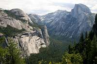
From Glacier Point’s lofty perch, one has dramatic views of Half Dome, Clouds Rest, North Dome, Yosemite Falls, Vernal Falls, Nevada Falls, Tenaya Canyon, and much, much more. However, it is no longer that spectacular wilderness view that delighted Teddy Roosevelt when he camped on it with John Muir. Rather, today a well-traveled road leads to the top, and the valley below is filled with a Disney-esque atmosphere of tourism and entertainment, the “folly of man” as it were. During a summertime visit, one can expect to share the experience of visiting Glacier Point with dozens, perhaps even dozens of dozens, of others who are gawking at their magnificent surroundings. But, the purpose of this page isn’t to lament the loss of solitude in one of the most visually stunning locales on the planet. It’s rather to tell the reader how he might recapture a little piece of that experience that so delighted Teddy Roosevelt one spring morning in 1903.
Getting There
Glacier Point is located in Yosemite National Park, CA. Getting there is thoroughly discussed on the SP Yosemite National Park page Getting There and Public Transportation Section. Exactly where you want to get, however, depends on how you want to get to the top of Glacier Point. That is further discussed below, depending on your decision.
Red Tape
Yosemite National Park requires an entrance fee or an entrance pass. The options are thoroughly discussed on the SP Yosemite National Park page in the Red Tape Section. In addition, there is no backcountry camping in Yosemite without a wilderness permit. The procedures for obtaining a permit are also explained on the Yosemite National Park page in the Wilderness Permit Reservations Section. These procedures do not affect day hikers; a permit is not required. Specific procedures for wintertime users via Badger Pass are provided below.
Camping
Yosemite National Park has numerous campgrounds and lodges. While these are usually filled to capacity during the tourist season, there are also numerous commercial campgrounds and hotels in nearby towns (expect an hour or so drive to Yosemite Valley). Visit the SP Yosemite National Park page Camping Section and Lodging Section for further information.
Routes
Yosemite National Park is riddled with hiking trails, and it’s entirely possible to create an itinerary that will afford a unique experience. However, this page will present one of the more popular ones, and provide descriptive information and links for several others. But, first …
Driving/Riding the Bus
As previously mentioned, one can drive to the top. Or, one can even take a bus to the top (There is a fee for the ride from the Yosemite Valley floor). While I wouldn’t encourage one to drive or ride both to the top and back down, certainly using a car or the bus as a one-way option to shorten the day (and perhaps enjoy the easier downhill path for the hike) may prove handy.
Driving Directions to Glacier Point: From Mariposa, drive east on Highway 140 to the Arch Rock Entrance Station. Continue six miles to Highway 41/Wawona Road. Turn right and travel nine miles to Glacier Point Road. Turn left and drive 16 miles to the parking area. The road to Glacier Point is closed once winter sets in.
Guided Tour Bus to Glacier Point: From late spring to early fall, the tour bus departs from Yosemite Lodge at specified times each day. The return trips from Glacier Point are also on a specific schedule. For additional details, or to may make reservations to ride to the top prior to your arrival in the park, visit here. You may also visit any Tour and Activity Desk in the park for additional information and reservations.
| A note about the Climber's Log: Please sign the Climber's Log only if you've climbed, hiked, skied, skated, snowshoed or biked (on the paved road) to Glacier Point, or from Glacier Point to points elsewhere. No two-way car/bus drivers/riders please. |
Four Mile Trail
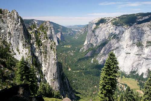
Four Mile Trail starts on Yosemite Valley floor and ascends 3220-feet in 4.6 miles (it was extended to make it less steep) to end at Glacier Point. During the first half of the ascent, it provides spectacular views of Yosemite Valley, Yosemite Falls, El Capitan, Cathedral Rocks, Sentinel Rock and the Merced River. Later in the hike the views of Half Dome, Clouds Rest, North Dome, and Tenaya Canyon are unparalleled. Near the end of the hike the view of Glacier Point and Half Dome will completely take away what little breath you have left. Stunning is an inadequate description. One must experience it to truly appreciate it. It is the primary reason that it is best to hike from the bottom to the top: If one starts with this view first, everything afterwards will be diminished.
 Half Dome and Glacier Point from Four Mile Trail.
Start your hike at the Swinging Bridge at road marker V18. Because this is a popular trail (during the summer months, anyway), you shouldn’t have any difficulty finding it. If the small trailhead parking area is full, you can park at one of the nearby public parking lots and take a Yosemite shuttle bus to the trailhead for free.
The trail begins with a short hike across a grassy field, and then continues with a gentle ascent up the face of the valley wall. After a short distance you will begin a series of switchbacks that will have nice views of the Merced River, El Capitan, Cathedral Rocks and Sentinel Rock. If you’re hiking during the tourist season, expect to see at least a few dozen other hiking parties. However, if the weather is foul, you may be blessed with complete solitude on the trail: Bring your raingear! You will have many places where you can see Yosemite Falls, though in the later months of summer it may not be very impressive.
As you ascend higher the trail has fewer switchbacks. It is mildly rocky, but not too much so. About three miles out you will reach the trail gate, where the trail is closed during the winter months. If you are able to continue to the top, and it’s tourist season, you’ll probably start to see hikers headed down. Many of them will be off the tourist bus, and will only be traveling a short distance along this trail before turning around. Once you reach the top, you’ll be very close to the gift shop (on your right, and where just about everyone buys an ice cream cone – one advantage of having this be a popular destination), and Glacier Point itself (about one hundred yards past some rocks to your left).
Other Routes
Panorama Trail
A longer, but far less crowded option to hiking the Four Mile Trail, this 8.5-mile (one-way) trail offers a similar 3200-foot ascent.

Park at Camp Curry in Yosemite Valley (if hiking up) and take the shuttle to stop #16 to access the Happy Isles trailhead. To reach the Panorama Trail, take the trail to Vernal and Nevada Falls from Happy Isles. Once you reach the Vernal Falls bridge (with a gorgeous view of the falls), you can take either the Mist Falls Trail (steeper, but takes you to the top of Vernal Falls) or the John Muir Trail (less steep, but views may not be as nice). You'll find the fork for the Panorama Trail at the top of Nevada Falls. It continues along the Panorama Cliff, and crosses beautiful Illilouette Fall. The Panorama Trail offers some incredible, panoramic views of Yosemite Valley. Don't miss the short (100-yard), unsigned side trail to Panorama Point (it's marked on the USGS quad topo extract and the Trails Illustrated® map #206, Yosemite National Park Trail Map). Panorama Trail is closed in the winter. Many folks combine this trail with the Four Mile Trail to form a large loop with beautiful views of different parts of the park.

Ledge Trail
(Note: Much of this taken from Bob Burd's route page)
The Ledge Trail, sometimes called One Mile Trail, was built in the 1930s by the CCC as a short, Class 3 route between the Yosemite Valley floor and Glacier Point. It runs along a fairly wide shelf diagonally up and to the right (west) directly behind Curry Village, and two-thirds of the way up to the Valley rim. From there it intersects a steep gully that angles up and to the left, taking one to within a 1/4-mile of Glacier Point. Officially, the trail does not exist because of the high rock slide potential (two significant rock slides as recently as October 2008). In many places there are paint stripes to mark the old trail. Warning signs at both ends of the trail indicate "Trail Closed". Bob Burd explains on his route page that this just adds to the charm.
Glacier Point Apron
The Glacier Point Apron, behind Curry Village, has a number of technical climbing routes, some of which lead to Glacier Point itself. Unfortunately, recent and ongoing rockfalls in this area have caused the park service to recommend against further climbs (two significant rock slides as recently as October 2008). In addition, some areas around Glacier Point are closed due to nesting Peregrine Falcons (more info). For more information about the risks and routes for climbing in this area:
o Rock falls from Glacier Point above Camp Curry, Yosemite National Park, California
USGS report about the history and continuing problem of rockfalls above the Glacier Point Apron.
o Rockclimbing.com Glacier Point Apron Climbing Route Listing
A listing of technical climbing routes on the Glacier Point Apron. Some of the routes lead to the top of Glacier Point.
Badger Pass
In the wintertime, Glacier Point is accessible via a 21-mile (roundtrip) journey along intermediate, groomed ski trails from Badger Pass. These trails are suitable for the adventurous skier or skater. The trail from Badger Pass to Glacier Point provides a great opportunity to enjoy wonderful wintertime views of Yosemite Valley, Half Dome and the Yosemite high country. In general, winter wilderness users may camp one mile away from any road and out of sight of any trail, water source or summer use area. A wilderness permit (free in winter) is required. Reservations are not required in the winter.
Guided ski packages are also available for overnight trips ending at the rustic accommodations of the Glacier Point Ski Hut. The hut includes a dining area, a common area surrounding a wood stove, lavatory facilities and a large bunk area that accommodates up to 20 skiers. You can learn more about the hut and other ski packages at this website:
o National Parks Reservations for Badger Pass Ski Area
Provides detailed information about Badger Pass Ski Area, including guided ski trips to the Glacier Point Ski Hut.
External Links
o NPS Yosemite National Park Website
Official NPS website for the park.
o Trails Illustrated® map #206, Yosemite National Park Trail Map
Excellent topo map of the park.
o Rock falls from Glacier Point above Camp Curry, Yosemite National Park, California
USGS report about the history and continuing problem of rockfalls above the Glacier Point Apron.
o Rockclimbing.com Glacier Point Apron Climbing Route Listing
A listing of technical climbing routes on the Glacier Point Apron. Some of the routes lead to the top of Glacier Point.
o Half Dome Quadrangle Topo Map (.tiff)
Quick link to the USGS Half Dome quadrangle that includes Glacier Point. This large file is used under the Creative Commons License.
o National Parks Reservations for Badger Pass Ski Area
Provides detailed information about Badger Pass Ski Area, including guided ski trips to the Glacier Point Ski Hut.