
|
|
Mountain/Rock |
|---|---|
|
|
47.43390°N / 121.7418°W |
|
|
Hiking |
|
|
Spring, Summer, Fall, Winter |
|
|
1880 ft / 573 m |
|
|
Overview
Cedar Butte
Elevation 1880 ft
Cedar Butte, a smaller summit near the Iron Horse Trail, is a classic hiking destination. Though the mountain is overshadowed by the closeby mountains of Rattlesnake Mountain, Mount Si, Little Si and Mount Washington, Cedar Butte features decent views from the summit and a good set of YDS class 1 trails around and to its summit. It should be noted that as of 2011 the trail to the summit has been renovated and is in very good shape. The trail to Boxley's Blowout is quickly becoming overgrown. It is often used for people either going on their first hike (YDS Class 1, 3 miles roundtrip), people wanting a good evening hike or a bad weather hike.
The Route
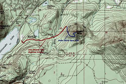
Cedar Butte Trail Map
The easiest way to get to the summit is to take the Iron Horse Trail from Cedar Falls Road head up the Iron Horse Trail (a former railroad gauge converted over to a walking path) about 0.8 miles. Roughly a quarter mile past Boxley Creek you want to look for a sign marking the route up Cedar Butte on the right. Take this trail all the way to the fork about 0.3 miles from the Iron Horse Trail. Merge to the left to head to the true summit or make a right to if you want to do a loop and head toward Boxley's Blowout. There was no major view by Boxley Blowout that I saw, just an interesting shot down at a blowout that not only knocked out a railroad gauge but a small town as well.
Views from Cedar Butte
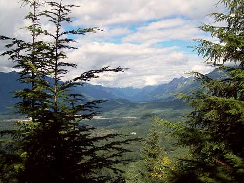
The main trail will continue until it reachs another 4 way intersection roughly 0.2 miles from the summit. Make a left here and head to the summit. Once on the summit enjoy the views northeast to both Mount Si and Mailbox Peak. The shot below taken by ericnoel is a good example of the views seen on Cedar Butte. The trail has recent been fixed up and now is very easy to follow as of 2012.
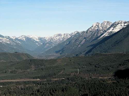
View taken by ericnoel of the summit of Cedar Butte towards the Cascades
Getting There
VIA THE IRON HORSE TRAILHEAD: From I-90 get off on Exit 32 and head south (Cedar Falls Road). Stay on the road and head past the Rattlesnake Mountain Parking area on your right hand side. The Iron Horse Parking Area will be on your left hand side about four and a half miles from the road.Weather Conditions
This is worst-case senario weather summit conditions for Cedar Butte. alt="Click for Snoqualmie Pass, Washington Forecast" height=60 width=468>
This weather is likely what to expect for mountain trailhead conditions.
 alt="Click for Bellevue, Washington Forecast" height=60 width=468>