
-
 36685 Hits
-
 89.42% Score
-
 30 Votes
|
|
Mountain/Rock |
|---|---|
|
|
54.52387°N / 3.01575°W |
|
|
Cumbria |
|
|
Mountaineering |
|
|
3117 ft / 950 m |
|
|
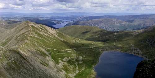
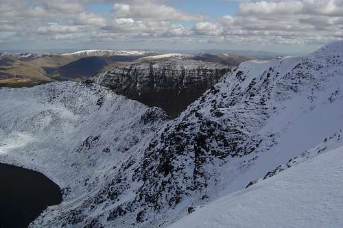
Looking down from Helvellyn over Red Tarn to hole in the wall
Overview
Helvellyn, (“Yellow Upland” in Cambric) is the third highest mountain in the Lake District.
It is the most famous and most climbed and walked of all the Lakeland fells.

Helvellyn especialy holds a place of honour in my list of mountains. It is one of the higher hills, yes it has lots of features, and yes it is a beautiful mountain, especialy seen from the eastern aspect. But the main reason for me, is that it was my first. It was the place that truly started my ambition to get high. Not on drugs, but on mountains.
On a frosty day during a cottage holiday, I went on a walk with two friends. I didnt pay much if any attention to the detail on the map (yes I had one) I just looked and set off on a circular route. It turned out to be
a fantastic discovery. A grand mountain with unexpected features and challenges. It also was a frosty clear day ending with a red sunset and a temp inversion. My day ended coming down Swirral edge at dusk, with the peaks poking through a layer of soft cloud illuminated by the setting red sun.........I loved it and now the mountain constantly draws me back, for a scramble over one of its crags, striding edge, or a winter gully climb.
The peak of Helvellyn is the highest on the north-south ridge situated between the Thirlmere valley to the west, and Patterdale to the east. This ridge continues north over Helvellyn Lower Man, White Side, Raise, Stybarrow Dodd, Great Dodd and Clough Head, and south leads to Nethermost Pike and Dollywaggon Pike.
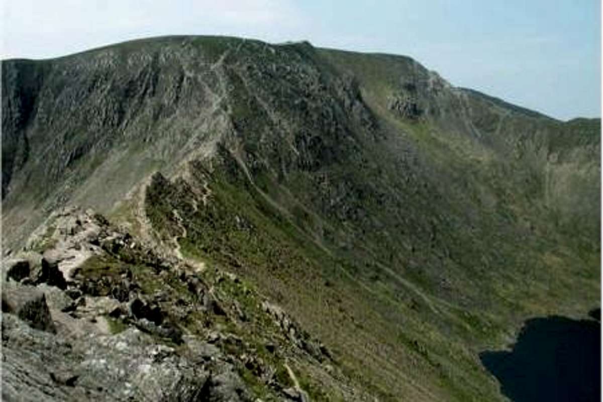
The eastern side of the fell is geographically the most dramatic. Two sharp arêtes lead off the summit, Striding Edge and Swirral Edge, either side of Red Tarn. The knife-edged Striding Edge provides one of the best-known scrambles in Lakeland, while the Swirral Edge ridge leads to the conical summit of Catstye Cam.
Nestling between the encircling arms of Helvellyn's two edges, is Red Tarn. This pool is named for the colour of the surrounding screes rather than its water, and contains brown trout and schelly, a fresh-water herring. The depth of Red Tarn is now about 80 ft, although in the mid 1800s it was dammed with boulders to increase capacity. This was carried out to provide additional water to the Greenside lead mine in Glenridding, the water race still visible as it crosses the slope of Birkhouse Moor.
The western slopes bear witness to historic mining activity. Helvellyn (or Wythburn) mine operated from 1839 until 1880, when the land was acquired for the Thirlmere reservoir scheme. Four levels can be found along the course of Mines Gill, from where lead was extracted. Despite the sizeable workings the venture was never a commercial success.
The western slopes are relatively shallow, and partially forested, with many gills leading down to the Thirlmere valley.
The Helvellyn Range......................
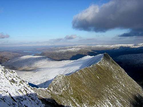
Below is a view from the south on St Sunday crag. It looks accross the front (East side of the range, from Dolywagon Pike, Nethermost and to helvellyn). You can see the ridge from Striding edge just visible on the far right skyline.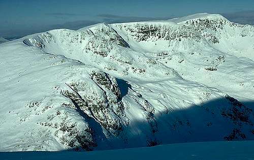
Getting There
There are two sides to approach the mountain from normally.
Depending on the route you want to take. Either make your way to the West or East side of the mountain.
The West side
You need to get to thirlmere. On the A591 South from Keswick, North from Ambleside. There is a carpark about half way along the lake at Swirls. There is a toilet. Or less interesting but shorter, Wythburn near Nethermost Pikes rear end.
The East Side
At the southern end of Ulswater on the A592. You can pick a route from either Glenridding (normally) or Patterdale village. There is parking at Either although it can get very busy, so you may have to be flexable in your choice.
Camping
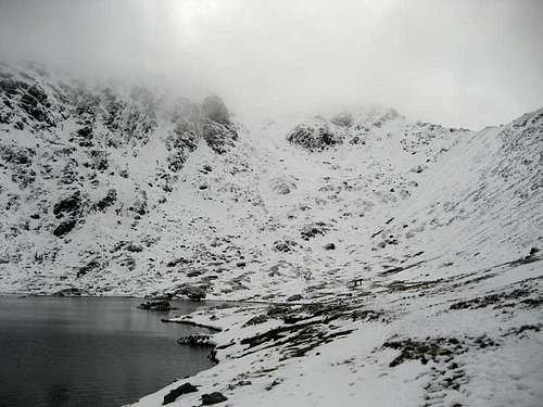
Wild Camping is often done up by Red Tarn as it is more sheltered and provides a secluded and beautiful camping spot.But remember to take away any sign of your being there.
Walking Route examples
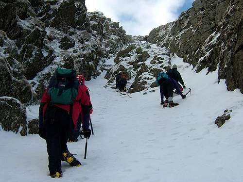
There is a wide range of routes on the Helvelyn range. It is therefore easy to find one tailored to your needs and desires. It is worth looking at some of the fantastic websites to get an idea of the terrain and sistances. Some of them are listed below.I have been up Helvellyn many times. It is worth the time to look at different routes. The normal classic way to start is of course up from Patterdale, to hole in the wall. Go along striding edge up onto the top, down Swirral and back along the hill, maybe taking in Catsye cam on your way to the car. But the range has so much more. Try going around from Grisdale tarn and once up onto Dolywagon following the tops all the way along to Swirral again. There are also scrambles to be had on Eagle crag and Nethermost Pike, as well as the Striding edge classic. So take a long look and try something. There are a few examples below.
Walk route 1: Swirls - Browncove Crags path - Helvellyn - Browncove Crags path - Swirls
Distance: 4.75 miles Ascent: 2,540ft Time: 3 hours 20 minutes
---------------------------------------------------------------------------
Walk route 2: Patterdale - Grisedale - Ruthwaite Lodge - Ruthwaite Cove - Hard Tarn - east ridge - Nethermost Pike - Helvellyn - Swirral Edge - Catstycam - Red Tarn (Helvellyn) - Birkhouse Moor - Lanty's Tarn - Grisedale - Patterdale
Distance: 10.50 miles Ascent: 3,300ft Time: 6 hours 30 minutes
---------------------------------------------------------------------------
Walk route 3: Swirls - Browncove Crags path - Helvellyn - Helvellyn Lower Man - White Side - Raise - Sticks Pass - Stybarrow Dodd - Watson's Dodd - Great Dodd - Calfhow Pike - Clough Head - Threlkeld Knotts - Hilltop Quarries - Wanthwaite
Distance: 10.75 miles Ascent: 4,000ft Time: 6 hours 45 minutes
---------------------------------------------------------------------------
Walk route 4: Wythburn - Whelpside Gill - Brownrigg Well - Helvellyn - Swallow Scarth - Nethermost Pike - Dollywaggon Pike - the head of Raise Beck - Seat Sandal - Dunmail Raise - Wythburn
Distance: 7.00 miles Ascent: 3,450ft Time: 5 hours 15 minutes
---------------------------------------------------------------------------
Walk route 5: Glenridding - Lanty's Tarn - Grisedale - Grisedale Tarn - Dollywaggon Pike - High Crag, Grisedale - Nethermost Pike - Helvellyn - Helvellyn Lower Man - White Side - Raise - Sticks Pass - Sticks Gill - Greenside Mine - Greenside Road - Glenridding
Distance: 13.00 miles Ascent: 3,450ft Time: 5 hours 5 minutes
---------------------------------------------------------------------------
-recomended--recomended--recomended--recomended--recomended--recomended-
Walk route 6: Glenridding - Mires Beck path - Birkhouse Moor - Hole-in-the-Wall - High Spying How - Striding Edge - Helvellyn - Swirral Edge - Catstycam - Red Tarn (Helvellyn) - Red Tarn Beck path - Glenridding valley - Glenridding
Distance: 9.25 miles Ascent: 3,020ft Time: 5 hours 20 minutes
-recomended--recomended--recomended--recomended--recomended--recomended-
---------------------------------------------------------------------------
for theese and many other walks, go to for info and pictures.
Sun or snow
The great thing about so called small mountains, is the ability to go for a long stroll in the sun with the family one month, and have a challenging winters day another..........sometimes the same month!Helvellyn sits in a location that seems to guarentee that if the lakes has snow, then it will be the best.
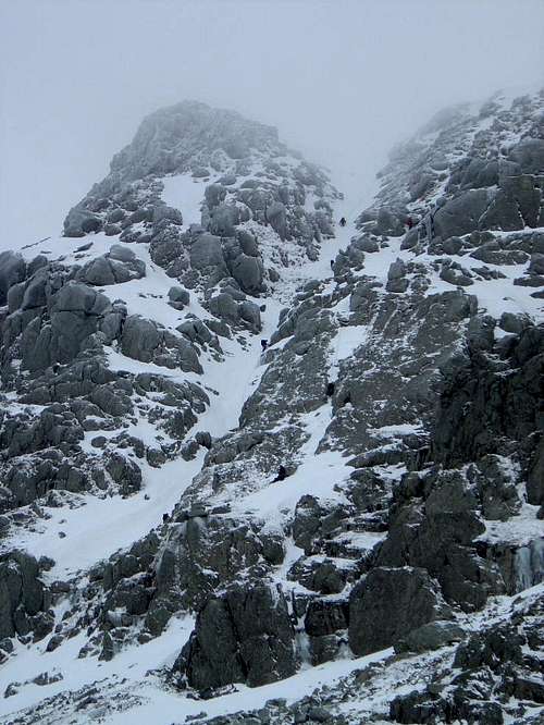
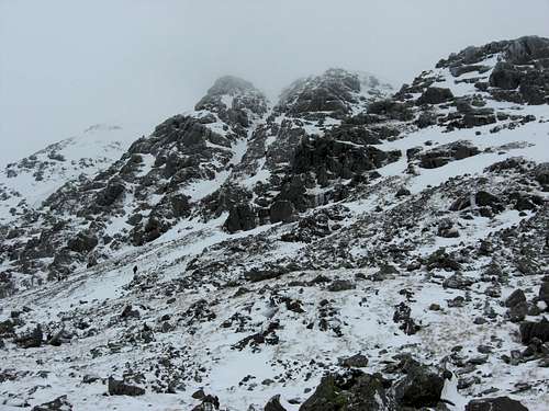
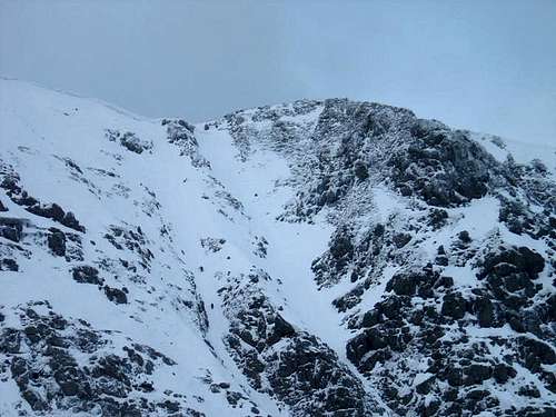
Below are three pictures. the first (1) of striding edge and Helvellyn. If you look way to the left of the ridge in the shadows you can see a gully to the top &(1a)another winter view accross the East side from the top of Swirral edge to Striding Edge.... Swallow or Nethermost gully a low grade snow climb pictured (2).
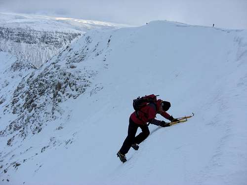
Picture (3 below) is on the West side of the mountain on Brown Cove Crag. In a easy gully. Fantastic place in all seasons. But dont forget to check the weather forecast, and of course be prepared!
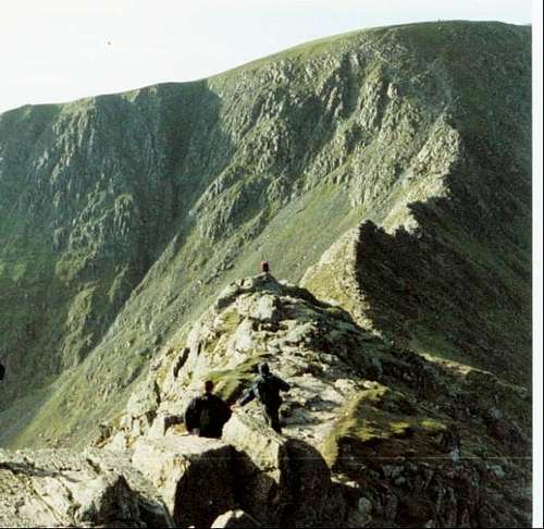
Striding Edge(1)
East Corniced edge from Swirral to Striding Edge(1a)
Swallow or Nethermost Gully(2)
The West side of the mountain, Via Brown Cove Crag
Central gully feb 09
There are two main places to start on the west side of the mountain. The most common and best is from Swirls car park (with toilet!).
The path leaved the carpark and zig zags up towards the crag. Before Brown Cove Crag is reached there is the option to go below (left) or over the crag (right). This is the normal option. But If you have any intention of a scramble, or a winter climb, dont hesitate to try the delights of this crag. It is an ideal preamble to the summit of Helvelyn. Or indeed even a location good enough to be your main destination on winter days.
Brown Cove Crags feb 09
Paralell Gullys (left of main Butress)
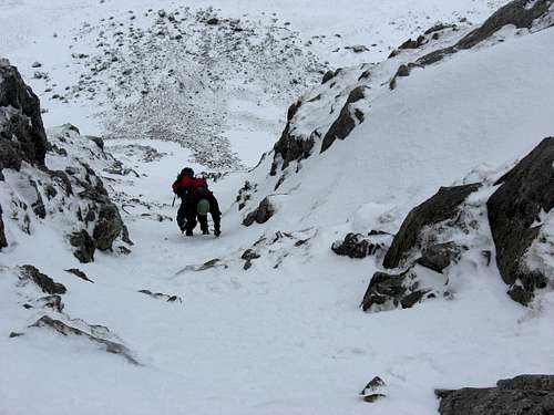
Brown Cove Crag, Right Paralell Gully(3)
Weather and External Links
The Lake District national park authority has two 'Fell top assessors' who ascend Helvellyn daily during the winter months of December to March. Their job is to check the weather conditions at the summit and write a report containing information such as temperature, windchill, windspeed, snowdepth, and any dangers such as unstable snow/avalanche hazard and icy footpaths. This report is put on the Weatherline, which is a Met Office mountain weather forecast and is available on the internet, by telephone and at local shops and tourist information centres. This information is important for people that go out winter hillwalking and climbing as it can help them plan their routes and to get an idea of the mountain conditions---------------------------------------------------------------------------
Helvellyn Website. Containing area info, shopping,walks, pictures,places to stay and more...... www.helvellyn.com
---------------------------------------------------------------------------
Leanys lakes Some great info and pictures
---------------------------------------------------------------------------
Striding Edge website Area info, Helvellyn page
---------------------------------------------------------------------------
YHA yha lakes
---------------------------------------------------------------------------
Lakes weather Forecast www.escape2lakedistrict.com
---------------------------------------------------------------------------
Mountain Conditions + daily picture (winter)http://www.lakedistrictweatherline.co.uk/