
-
 15285 Hits
-
 89% Score
-
 28 Votes
|
|
Mountain/Rock |
|---|---|
|
|
32.01420°N / 109.3248°W |
|
|
Cochise County |
|
|
Hiking |
|
|
Spring, Summer, Fall, Winter |
|
|
7310 ft / 2228 m |
|
|
Overview
Sugarloaf Mountain is a gentle dome standing quietly above the hoodoo-studded magic of Chiricahua National Monument, called “The Land of Standing-Up Rocks” by the Apache. Hikers reaching the summit take in 360-degree views of the surrounding canyons, valleys and peaks. From the summit, hikers can look into and across numerous canyons including Echo Canyon to the south, Rhyolite Canyon to the southwest and Lost Canyon to the west. The San Simon Valley is visible to the southeast while the Sulphur Springs Valley sprawls to the west. Peaks visible from the summit include Cochise Head to the northeast and the Dos Cabezas Mountains to the northwest beyond Apache Pass. The Dragoon Mountains lie in the distance to the west, across the Sulphur Springs Valley.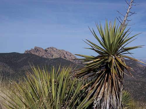 Cochise Head from the summit of Sugarloaf Mountain
Chiricahua National Monument, Arizona, USA
18 Feb 2008
Cochise Head from the summit of Sugarloaf Mountain
Chiricahua National Monument, Arizona, USA
18 Feb 2008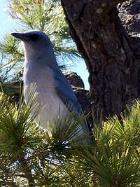 Camp Robber Jay hoping for handouts in Chiricahua National Monument
18 Feb 2008
Camp Robber Jay hoping for handouts in Chiricahua National Monument
18 Feb 2008 The gentle hump of Sugarloaf Mountain crowned by a fire lookout tower
Chiricahua National Monument, Arizona, USA
18 Feb 2008
The gentle hump of Sugarloaf Mountain crowned by a fire lookout tower
Chiricahua National Monument, Arizona, USA
18 Feb 2008Getting There
Chiricahua National Monument is located 120 miles southeast of Tucson and 240 miles from Phoenix. The nearby town of Willcox is 35 miles northwest of the monument. Take I-10 east from Tucson to the first exit for Willcox. Travel 3 miles into town to the stoplight and turn right. Follow Arizona State Highway 186 for 32 miles to the junction of Arizona State Highway 181. Turn left and within 4 miles arrive at the Chiricahua entrance station. From the visitor's center follow the Bonita Canyon Drive for approximately 7 miles. The turnoff for Sugarloaf/Echo Canyon will be on the driver's right. Proceed a short distance to the Sugarloaf Mountain Trailhead parking. Summit lookout tower on Sugarloaf Mountain
Chiricahua National Monument, Arizona, USA
18 Feb 2008
Summit lookout tower on Sugarloaf Mountain
Chiricahua National Monument, Arizona, USA
18 Feb 2008Red Tape
No pets are allowed on the Sugarloaf Mountain trail. Per technicolorNH, as of 2018 an entry fee is no longer in place. Updated details from the National Park Services, which manages National Monuments, can be found here: https://www.nps.gov/chir/planyourvisit/fees.htm
Chiricahua National Monument is open year round. The monument visitor center is open daily from 8:00 a.m. to 4:30 p.m., closed Thanksgiving Day and December 25. Remember most of Arizona does not use Daylight Savings Time.
![USGS Marker, Sugarloaf Mountain Summit]() USGS Marker, Sugarloaf Mountain Summit
Chiricahua National Monument, Arizona, USA
18 Feb 2008
Bonita Canyon Campground is located within the National Monument. It supplies 22 individual campsites, available first-come, first-served; no reservations are accepted.
Primitive camping is available in the surrounding Coronado National Forest. Visit www.fs.fed.us/r3/coronado or call the Douglas Office for more information (520-364-3468).
Numerous hotels can be found in nearby Willcox (35 miles away) including:
USGS Marker, Sugarloaf Mountain Summit
Chiricahua National Monument, Arizona, USA
18 Feb 2008
Bonita Canyon Campground is located within the National Monument. It supplies 22 individual campsites, available first-come, first-served; no reservations are accepted.
Primitive camping is available in the surrounding Coronado National Forest. Visit www.fs.fed.us/r3/coronado or call the Douglas Office for more information (520-364-3468).
Numerous hotels can be found in nearby Willcox (35 miles away) including:![Sulphur Springs Valley from Sugarloaf Mountain Summit]() Looking out across the vast Sulphur Springs Valley from the Sugarloaf Mountain Summit
Chiricahua National Monument, Arizona, USA
18 Feb 2008
Fall, winter and spring are the best seasons to visit Chiricahua National Monument. Winter brings mild, sunny weather with highs typically in the 60s and lows in the 20s (Fahrenheit). Anticipate snow between November and March. Spring and fall are warm and sunny.
Summer begins with baking heat (May and June are hot and dry) and then July ushers in the monsoon, with daily thunderstorms lasting through early September.
Looking out across the vast Sulphur Springs Valley from the Sugarloaf Mountain Summit
Chiricahua National Monument, Arizona, USA
18 Feb 2008
Fall, winter and spring are the best seasons to visit Chiricahua National Monument. Winter brings mild, sunny weather with highs typically in the 60s and lows in the 20s (Fahrenheit). Anticipate snow between November and March. Spring and fall are warm and sunny.
Summer begins with baking heat (May and June are hot and dry) and then July ushers in the monsoon, with daily thunderstorms lasting through early September.
Camping & Lodging
 USGS Marker, Sugarloaf Mountain Summit
Chiricahua National Monument, Arizona, USA
18 Feb 2008
USGS Marker, Sugarloaf Mountain Summit
Chiricahua National Monument, Arizona, USA
18 Feb 2008- Best Western
- Days Inn
- Super 8
- Royal Western Lodge
- Desert Inn of Willcox
Seasons
 Looking out across the vast Sulphur Springs Valley from the Sugarloaf Mountain Summit
Chiricahua National Monument, Arizona, USA
18 Feb 2008
Looking out across the vast Sulphur Springs Valley from the Sugarloaf Mountain Summit
Chiricahua National Monument, Arizona, USA
18 Feb 2008
technicolorNH - Sep 11, 2018 4:18 pm - Hasn't voted
Chiricahua National MonumentThe area is now free to enter. Campsites still require a fee but the Visitor Center and entire area are free for day visitors and hikers.
Sarah Simon - Nov 25, 2018 4:45 pm - Hasn't voted
Re: Chiricahua National MonumentI appreciate the update and am revising the page accordingly!