

-
 13869 Hits
-
 90.13% Score
-
 31 Votes
|
|
Mountain/Rock |
|---|---|
|
|
46.44543°N / 9.72290°E |
|
|
Mountaineering, Skiing |
|
|
Spring, Summer, Fall |
|
|
10384 ft / 3165 m |
|
|
Overview
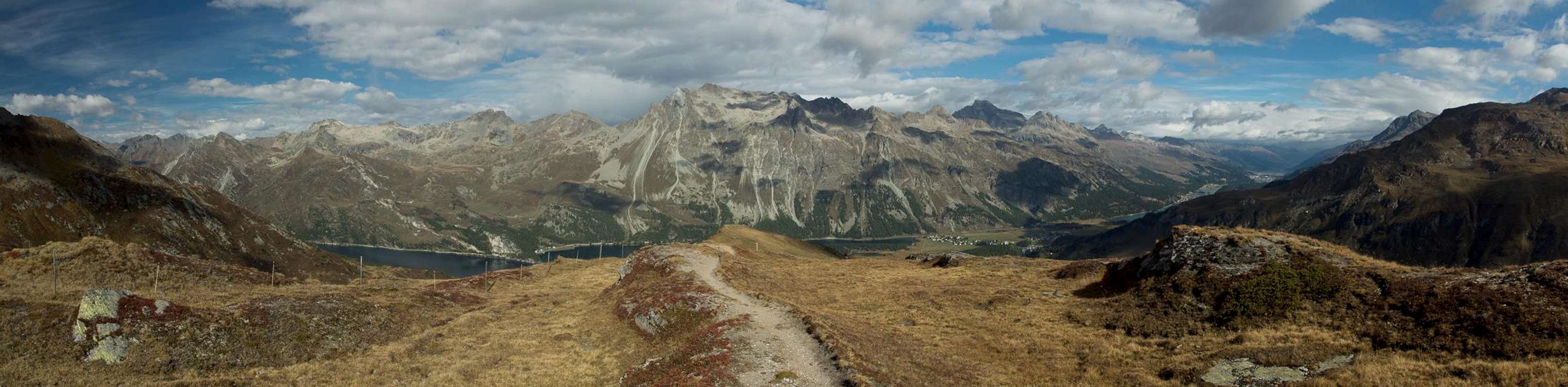
 Piz Lagrev above Lej da Segl Piz Lagrev above Lej da Segl |
Piz Lagrev is the highest mountain of the southernmost subgroup of the Albula Laps. At 3165m it is not exactly impressive in height but the sheer bulk of the mountain makes up for it. Seen across Oberengadin Valley it dominates the surrounding mountains by its wide summit ridge which gradually runs up to several summits, all above 3100m. Beyond these summits sheer drops separate the mountain from its neighbours on its southern side.
 |  |  |
Piz Lagrev is located rather centrally in the triangle which is created by three of Europe's oldest mountain passes, all being used in Roman times already. Maloja-Pass to the south separates it from the Bernina Group, Septimer pass to the east separates it from the Platta Group while Julier Pass separates it from the bulk of the main subgroups of the Albula Alps.
 |  |  |
It is in this latter part, that the most frequently used route to Piz Larev's summit starts, a long scramble across rock and boulder fields and a small glacier with a long panoramic ridge traverse at the end. The route is mainly done as a ski tour in winter, when the snow cover hides the most uncomfortable sections in the boulder fields. However, the north side of Piz Lagrev is avalanche prone, so that you need to inquire into current conditions before you start. The ski tour usually ends at the winter summit at 3109m, a small saddle and rouhgly 50m of elevation away from the main one.
 |  |  |
As the highest point of its subgroup, Piz Lagrev is an excellent lookout, famous for its views towards Bernina and its southern satellites in the Val Massino Alps. On the other hand its prominence ensures the mountain itself is visible from all sides, which makes it a very popular target for photography. Especially the view across Lej da Segl offers stunningly different aspects of the mountain.
Getting There
  |
The usual trailhead for Piz Lagrev is at or near Pass dal Güglia / Julierpass at 2050m. Alternatively you can start at Alp Güglia at 2160m. The pass can be easily reached from St. Moritz, which itself can be reached by
- B27 from Zernez in the north
- B29 from Valtellina (Italy) across Berninapass from the south-east
- SS37 / B3 through Val Bregaglia / Bergell from Chiavenna (Italy) in the south-west
- B3 from Chur in the north-west.
Route
 Piz Lagrev with the upper part of the route across the glacier and along the ridge
Liz Lagrev is mainly a ski touring mountain. A classic tour leads to its summit from Julierpass / Pass dal Güglia with about 1000m elevation gain. The same route can also be climbed in summer but large scree and boulder fields as well as the crossing of the little Vadret Lagrev glacier limits its attractivity. However, if you aim for a solitary ascent, this is the mountain to go to.
Start at the Julier Pass Road, descending to about 2000m, before crossing the creek on a bridge and following the signs to Lej da Tscheppa. The path switches back and forth, also with quite some ups and downs until it reaches the beautifully colourful (in the summer) lake.
In the next stage follow the lake to its northern end on its eastern shore. From there head for the small glacier, Vadret Lagrev, heading for an obvious summit, already in reach of the glacier where you find a large signboard introducing the nature preserve in this part of the Albula Alps. Head across the morraines towards the tip of the glacier.
 |  |  |
The glacier can be traversed anywhere. It is not too steep and contains only few crevasses. In its topmost part head for its eastern tip, from which you'll reach a foresummit at 3085m which carries a weather station. Now, follow the ridge towards the north summit (3109m), which is the usual end of the ski tour. Stay on the ridge to head for the main summit at 3164m.
Difficulties:
- Summer route: L-WS (F-PD)
- Ski tour route: ZS-
Accommodation
 |  |  |
Weather Conditions
 Piz Lagrev above the clouds
Maps & Books
Maps
Digital Maps
Regular Maps
- Julierpass
Swisstopo Map LK 268 T
1:50000
ISBN: 978-3302302683
- St. Moritz
Swisstopo Mao LK 1257
1:25000
ISBN: 978-3302012575
- Oberendagin / Alta Engadina
Kompass Verlag
1:40000
ISBN: 978-3850269094
Books
- Bündner Alpen 6
Manfred Hunziker
Sac Schweizer Alpenclub
ISBN: 978-3859021877
- Oberengadin - St. Moritz, Zuoz, Pontresina
Rudolf Weiss, Siegrun Weiss
Rother Verlag
ISBN: 978-3763340422
- Unterengadin. Scuol - Zernez - Münstertal
Rudolf Weiss, Siegrun Weiss
Rother Verlag
ISBN: 978-3763340439
- Skitouren Graubünden Süd: Oberhalbstein / Albula / Davos / Engadin
Vital Eggenberger
Sac Schweizer Alpenclub
ISBN: 978-3859023017
In Memory of Cyrill Rüegger
 A note from the SP staff
Cyrill Rüegger, the member we all used to know as Cyrill and Digitalis, died on June 13th 2009 in an avalanche on the summit ridge of Piz Palü together with his wife Tanja and a common friend. They were swept down by the avalanche into a couloir underneath the east summit and died instantly. Their bodies were retrieved from the Palü Glacier by helicopter a day after the accident.
Cyrill joined SP in March 2006 and soon was one of the most prolific contributors on the site with almost 70 mountain and 5 range pages to his profile. He was an accomplished climber, bagging almost 1000 summits in not quite seven years. Among them are 35 4000ers and 272 3000ers, almost all of them in his home country Switzerland.
While contributing a lot on SP, Cyrill's real internet home was www.hikr.org where he contributed 585 mountain profiles and reports in his native language German. Cyrill also posted on www.bergsteigen.at and other climbing sites, often under his real name but also under the pseudonym Digitalis. He was a botanist by profession and also contributed his knowledge about medical plants to different websites. Cyrill will be greatly missed by all.
This page will be kept in honour of Cyrill, one of SP's most prolific members and most active mountaineers.
Rest in peace, brother!
The picture above was taken on the summit of Matterhorn on July 28th 2007.