
|
|
Mountain/Rock |
|---|---|
|
|
35.27890°N / 118.1366°W |
|
|
Kern |
|
|
Hiking |
|
|
Spring, Fall |
|
|
5203 ft / 1586 m |
|
|
Overview
Cross Mountain is part of the subsidiary Piute Range just north of Mojave in an area commonly known as the Tehachapis. Some sources cite the Piute Range as the southernmost section of the Sierra Nevada. According to the Sierra Club’s Hundred Peak Summits website, the mountain was named for a rancher and logger, Jeb Cross, who owned a ranch in the mid 1800s near the peak. Cross Mtn is often hiked with its neighboring peak, Chuckwalla, as they both appear on the Sierra Club’s HPS website. Cross is composed of interesting geological white and red rock that highlights it against the typical desert brown. And for those lucky enough to catch it after a good winter, the wildflower season is spectacular.Today, the area around Cross Mtn has earned the dual reputation as an off-road recreation spot (you may find yourself sharing the trails with motorcycles) and as part of the Tehachapi Wind Resource Area. The Jawbone Canyon area near Cross Mtn was a past host to a number of mining concerns, including the White Rock Mine where rhyolite was extracted and several mines directly south of Cross in Antimony Flats (mining antimony, of course). The most spectacular man-made site in the area is the Los Angeles Aqueduct which actually includes the original pipe (black) and the new pipe (white) that provides the water needs of thirsty Southern California. The aqueduct siphon at Jawbone Canyon is the longest of the entire pipeline dropping over 800 feet.
 Wildflowers on the southern flank of Cross Mtn (Apr 08)
Getting There
There are two approaches to Cross Mtn depending on the desired route. The primary approach, via Jawbone Canyon, is easy to find. The Jawbone Canyon Road lies 19.5 miles north of the City of Mojave off Highway 14. After turning west onto the road from the highway, proceed 6.3 miles to the point that Jawbone Canyon Road makes a sharp turn to the north. A locked gate bars further access west from this corner – park off road to access the two northerly routes (see current warning below).The remaining route is accessed through a convoluted approach (reasonable clearance vehicle required) via Lone Tree Canyon Road, 14 miles north of Mojave off Highway 14. Head west crossing under the new aqueduct pipe and then over the old pipe. Immediately turn right after crossing the old pipe to the end of the canyon where the road takes a 180 degree as it climbs out of the canyon (ignore two previous forks unless you want to examine aqueduct vents). At the top of the canyon, once again execute a 180 degree left returning to roughly a northerly direction (do not go straight). When the road makes a right turn and begins descending, take the fork to the left instead of following the main road. At this point the road becomes a bit rough but follow it up and over a bump finally parking at the point where the road wants to drop to the right again. The parking spot is obvious and lies at the foot of the steep ridge that marks the beginning of South Ridge route up to Chuckwalla Mtn. The trail to Cross Mtn actually begins after you hike to the top of this ridge. More detailed directions can be found here.
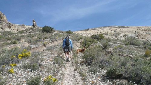
Starting up the steep slope
Routes
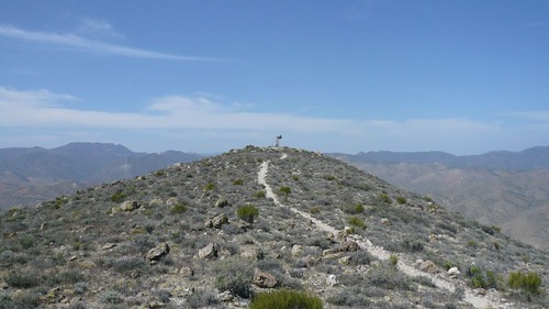
There are three common use trails that access the summit of Cross Mtn. All routes have roughly the same elevation gain but the two north approaches are considerably shorter. As of May 2008, the approach to the north facing routes is prevented by a security guard (at the locked gate) for the Los Angeles Department of Water and Power’s Pine Tree Wind Development Project. Although the mountain does sport several cliff bands, it can literally be approached from any direction. A traverse of Cross and its two subsidiary peaks is possible but the center peak is a near monolithic rock protrusion of unknown quality. This peak would require technical gear for both the ascent and descent.South Slope: Class 1. This is a straight forward hike on a good use trail from the west shoulder of Chuckwalla Mtn. Follow the road west down and then back up a bump. Turning north at the top, descend the ridge to the cabin ruins in the canyon south of the Cross massif. Hike up the canyon (take the left fork when it branches) to an old concrete pad and water tanks. Continue up the right canyon branch (the tank is in the left branch) until a steep use trail veers right up the south side of the southwest ridge. Follow the trail to the top of the mountain.
Northeast Slope: Class 1. This route starts at the locked gate at Jawbone Canyon. Follow the road west for 1.6 miles turning south to follow an old jeep trail up the ridge. Veer left to Cuddle Spring and take the obvious use trail up the slope of the mountain. This route is best used as a descent due to the large amount of scree on the upper slopes of Cross Mtn.
North Ridge: Class 1. This route is the same as the previous but instead going to Cuddle Spring, continue up the north ridge to the summit.
Looking back at the Cross highpoint
Red Tape , Camping, and Conditions
There are currently no permits required to access Cross Mtn. However, the approaches do cross Department of Water & Power property and closures may occur from time to time.Camping is best done in the canyon immediately south of Cross Mtn although sources of water may be limited.
Hiking can be done in almost any season but the late fall and spring time is best from a temperature perspective. Summer time will involve hiking in hotter high desert temperatures while a wet winter brings the danger of flash floods. Check for current weather.
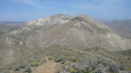
Cross Mtn on the far side
External Links
Trip Reports:HPS Trip Reports
Pictures:
My pics