-
 32097 Hits
-
 77.48% Score
-
 8 Votes
|
|
Mountain/Rock |
|---|---|
|
|
38.16652°N / 79.31392°W |
|
|
Augusta |
|
|
Hiking |
|
|
Spring, Summer, Fall, Winter |
|
|
4463 ft / 1360 m |
|
|
Overview
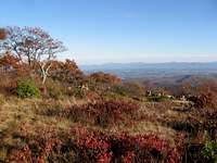
With its 4,463 foot elevation, Elliott Knob is the highest point in Augusta County, Virginia. The knob is actually the crest of a long ridge known as Great North Mountain and is also listed as the highest point in the George Washington National Forest. The partially open summit affords views stretching up and down the Shenandoah Valley from Massanutten to the Peaks of Otter.
The summit is also home to one of the few remaining fire lookouts in Virginia. Follow this link for more information on the fire lookout. Below the summit is a transmission station that is hard to ignore.
Despite the presence of so many man-made distractions around the summit, as well as the large, wide gravel access road that climbs its east side, the flanks of Elliott Knob are home to an Inventoried Roadless Area of nearly 10,000 acres. These are areas that have been identified as potentially meeting the definition of a Wilderness Area as set forth in the Wilderness Act of 1964.
Getting There
There are multiple approaches to the summit. Each is easily accessed from Buffalo Gap. Buffalo Gap can be reached by traveling approximately 10 miles west from Staunton on VA-254, or south from Churchville and US-250 on VA-42.
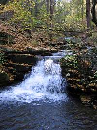
The most well-known route is the Falls Hollow Trail. This trail can be reached off of VA 42 south of Buffalo Gap. Park at a small pull-in and gate - there is a stop sign with the number '291' attached to it. The trail follows an old forest road through several small clearings and then drops into the hollow to follow Falls Run upstream. After leaving the stream, the trail slabs across the mountain until reaching an access road. Follow the steep access road to the summit area.
Distance: 4.25 miles one way
Elevation Gained: 2,425 ft.
Another route begins at Dry Branch Gap and follows the North Mountain Trail (sometimes referred to as the Elliott Knob Trail) to the summit area. Dry Branch Gap can be reached by accessing SR-688 from VA 42 just west of Buffalo Gap and following it to the ridge and trail head. Hike the North Mountain Trail south from Dry Branch Gap until reaching the summit area.
Distance: ~4 miles one way
Elevation Gained: 1,870 ft.
The North Mountain Trail also reaches the summit from the south, and can be reached by taking Hite Hollow Road. Follow VA-42 south from Buffalo Gap to Augusta Springs where Hite Hollow Road leaves on the right.
Distance: ~4 miles one way
Elevation Gained: 1,300 ft
The final hiking option is the Cold Springs Trail. Follow the directions to Dry Branch Gap but continue on SR 688 to Cold Springs Road (FDR 77). Turn Left and follow for 3.6 miles to where the trail leaves on the east side of the road.
Distance: 2.2 miles one way
Elevation Gained: 2,100 ft.
Red Tape
The fire tower and transmission stations are off limits (though it is obvious that the fire tower is accessed frequently by visitors). Check with the National Forest Service (link below) for seasonal restrictions such as campfire bans.
Camping
The summit is open and good sites can be found in the area around the fire tower. There is also a spring below the summit above a small pond just down the access road. The fire tower itself is off limits.
External Links
George Washington National Forest home page
Information on the Elliot Knob lookout on firelookout.net
Elliott Knob is also a stop on the Virginia Birding and Wildlife Trail.
technicolorNH - May 12, 2019 6:04 pm - Hasn't voted
MileageThe Falls Hollow TH is located 3.1 miles from Buffalo Gap. As of the time of this posting the stop sign, the gate, and #291 were still visible.