
-
 10051 Hits
-
 83.1% Score
-
 16 Votes
|
|
Mountain/Rock |
|---|---|
|
|
47.40877°N / 11.34179°E |
|
|
Hiking, Skiing |
|
|
Spring, Summer, Fall, Winter |
|
|
8428 ft / 2569 m |
|
|
Overview
 South slopes in winter
 Karwendelklamm
Pleisenspitze is the westernmost mountain of the Karwendel main ridge. Therefore the mountain is accessible in quite short time compared to the other summits of the main ridge. Additionally it is the only one of the higher mountains of the Karwendel which can be climbed in winter easily. Since it isn' t exceptional high it offers perfect views into all directions especially towards the rest of the Karwendel main chain.
About half way to the top, the Pleisen hut is a perfect place for a rest and to enjoy the views towards Scharnitz. The hut was built in the early 1950ies by the famous Toni Gaugg (called "Pleisen Toni") who is burried next to the hut he built all alone. During the summer months and on winter weekends the hut is open and well visited. The possibility to split the ascent to Pleisenspitze into two days increases the number of people climbing it.
The easiest way to ascent Pleisenspitze is via Pleisen hut and the "Hintere Pleisengrat"-ridge. During the summer months this route doesn' t offer any difficulties. If you plan to ascent this mountain in winter using your skies you' ll have to wait for secure avalanche conditions, since the part above Pleinenhut is quite steep and highly dangerous due to avalanches.
Since the mountain is frequently visited I recommend starting early in Scharnitz to be "in front of the crowd" to enjoy the summit alone. According to my experience most people start from the hut at about 9am and summit about 2-3h later. You can shorten the ascent by using your bike from Scharnitz to Pleisenhut.
Maps and routes overview
Maps:
Routes:
|  Vorderer Pleisengrat Vorderer Pleisengrat Steinmandl Steinmandl |
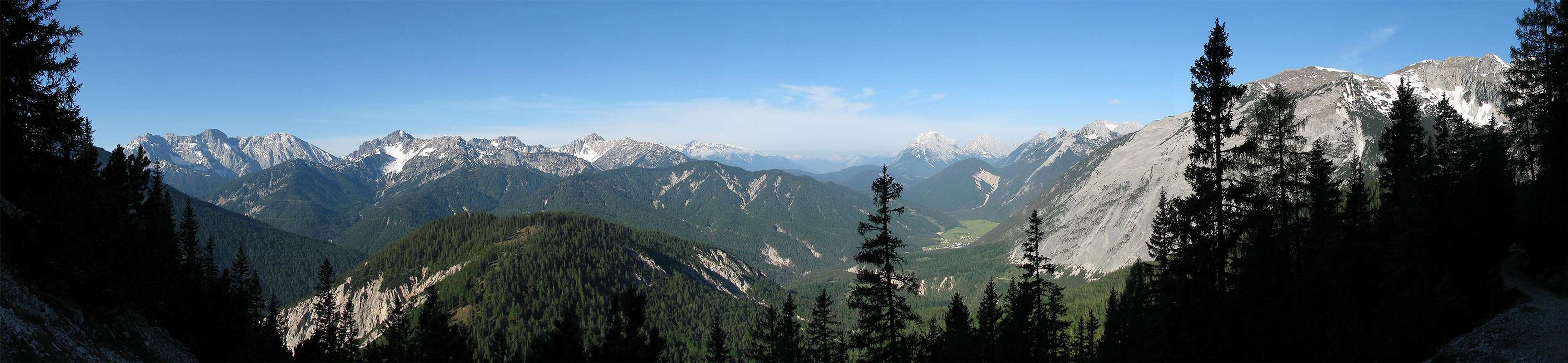
Panoramic views
  |
 |
Mountain conditions
Weather:
- www.wetter.com
Precise, but sometimes inaccurate weather forecast for the city of Scharnitz. - ZAMG
Not as detailed as the link above, but quite accurate forecasts. - OEAV weather forecast
Weather forecast especially for mountaineering porpuses. Unfortunately this page is available in german only. - Avalanche report (Tyrol/Austria)
As noted before, this german internet page offers the current avalanche report for Tyrol.
Webcams:
 | Webcam at Seefeld looking up to Ross-hut (1751m/5745ft), about 10km from Pleisenspitze. |
Getting There
| By car: | To reach the trailhead, you have to drive to the city of Scharnitz at the Austrian/German border. Road 177 and B2 which connects Innsbruck (Austria) and Garmisch-Partenkirchen (Germany) runs through Scharnitz. From Garmisch-Partenkirchen you have a highway connection to Munich and Innsbruck provides a conenction to Italy (Brenner). After reaching Scharnitz you' ll have to drive to the parkinglot of the Karwendel (watch for the signs close to the bridge at Scharnitz). Parking is not free and you' ll have to pay 3Euros per day. |
| By train: | If you go to Pleisenspitze by train your trailhead is the train station at Scharnitz. About every hour the train from Garmisch-Partenkirchen (Germany) to Innsburck (Austria) stops there. From Garmisch-Partenkirchen you have access to the trains to Munich, Ehrwald (Austria) and Rheutte (Austria). Innsbruck is the gateway to Italy (Bozen/Bolzano, Verona). |
Camping
The area around Scharnitz is very touristic with tons of hotels and places to stay. For more information visit the multilangual homepage of the area of Seefeld. Innsbruck and Garmisch-Partenkirchen aren' t far away as well.
Because of the nature reservation area Karwendel, camping on the mountain is forbidden. Additionally you should carry everything back down with you and leave only footprints. If you plan to stay on the mountain for a night, Pleisenhut is the only hut in the area.
Red Tape
There are no permits, fees or seasonal closures.
There is a parking lot at the beginning of the Karwendel valley which costs 3 Euro per day with a maximum parking of three days.
Pleisenspitze is part of the nature reservation area Karwendel and therefore it is forbidden to camp on the mountain. Additionally you shouldn' t pick up flowers and don' t leave anything but footprints.
Page history
| 8/Jun/2008 |
|