
-
 29623 Hits
-
 88.61% Score
-
 27 Votes
|
|
Mountain/Rock |
|---|---|
|
|
48.51806°N / 114.01972°W |
|
|
Flathead |
|
|
Hiking |
|
|
Spring, Summer, Fall, Winter |
|
|
5236 ft / 1596 m |
|
|
 The Apgar Mountains and Lake McDonald
Layout designed for best viewing on a "1024 x 768" screen.
The Apgar area in Glacier National Park was named after Dimon Apgar, who settled in this area in the late 1800’s and built a home at the foot of Lake McDonald. There are a number of trees in the area that are not native and they were part of his homestead.
The photo on the left was taken near Apgar Village and Campground. It is in this area that Dimon Apgar built his home.
There are services available in this area. Eddie's Resturant makes a killer burger and shakes after a long day of climbing. The Apgar Ranger Station is also found here.
Overview
Apgar Lookout is located on the Southeast end of the Apgar Mountains on the outlet end of Lake McDonald. The Apgar Mountains are a series of small points on the map. On the northwest end of the Apgar Mountains stands Huckleberry Mountain and its lookout which is 6,593 feet in elevation. About seven miles to the southeast is Apgar Lookout which sits at 5,236 feet.The total distance in this trip is 3.4 miles by trail to the lookout and another .25 miles to the highest point. Total elevation gained is 2,019 feet. The elevation gained to the lookout is listed as 1,835 feet.
 Smoke from a Montana Forest Fire
 Forest fire, posted by mrh, photo by A. Hiebert.
Please click on the linked text for more photos.
Much of the hike occurs through the remnants of the 2003 Roberts Fire which came within a few hundred yards of the Apgar Lookout. The Roberts Fire was man caused and it rapidly grew to over 3,200 acres in the first 24 hours. As it grew it combined with the lightening caused Wedge Fire and between the two fires a total of over 110,000 acres were burned. In Glacier National Park alone these two fires burned almost 75,000 acres. The town of Hungry Horse as well as Apgar itself were threatened by these fires.
I personally remember looking to the North from the Flathead Valley and seeing a tremendous plume of smoke which turned out to be the initial blow-up of the Roberts Fire. The fire itself caused incredibly smoky conditions throughout Northwestern Montana and on the West side of the continental divide in Glacier as well. Climbing that year in the park produced surreal experiences of walking above clouds of smoke with just a sea of peaks sticking out.
Upon reaching the Fire Lookout tremendous views of Lake McDonald and the numerous peaks of Glacier National Park await you. Here is an interesting story about how Lake McDonald got its name.
According to the National Park Service it all happened in about the year 1878. A man named, Duncan McDonald, son of a Hudson's Bay Company factor, Angus McDonald, visited this lake, which was then known as "Terry Lake," for General Terry, an outstanding Indian fighter of the west. Duncan, who had the job of freighting a large amount of supplies to Canada, had intended to go up the North Fork of the Flathead, probably over the present Kishenehn trail route, but, upon finding his way blocked by a band of unfriendly Indians, he swung eastward and started up the next adjacent valley paralleling the North Fork. At the close of day, accompanied by a group of Flathead Indians, he came to the shores of this lake and camped there overnight. While in camp that evening he carved his name upon the bark of a birch tree. The next day he continued his journey, reaching Canada safely. The tree bearing his name remained for many years near the present village of Apgar. People who saw the name on the tree gradually began to call it "McDonald's Lake," and so the name became fixed.
Getting There
 |  |
|---|
|
To visit Glacier National Park is to visit a place
were Heaven touches earth affording brief glimpses into the Wonders of Creation. |
Apgar Mountain and Lookout are located just a short distance from the West Entrance of Glacier National Park near West Glacier, Montana.
The "Crown of the Continent" is located in northwestern Montana and shares a border with Waterton International Peace Park in Canada. Driving the world renowned Going-to-the-Sun Road to Logan Pass is a great way to see Glacier. Typically Logan Pass and Going-to-the-Sun Road opens near the end of June but it can be as early as the middle of June and as late as after July Fourth. The road isn’t open in the winter but you can ski there.
Directions to the trailhead:
Apgar Lookout Trail is reached by taking the Apgar Horse Corral Road, halfway between Apgar and West Glacier Entrance. The signage is clearly marked on the Going-to-the-Sun Highway. If you reach either the Entrance Station or the three-way stop near Apgar turn around and look for the sign from the other direction. After turning onto Apgar Horse Corral Road follow road past the left hand turn to the Glacier Institute to a Y-intersection at the Quarter Circle Ranch, keeping to the left along the horse corral/pasture, follow the road to the Quarter Circle Bridge which crosses McDonald Creek at the confluence of the Flathead River and follow the road for approximately one mile. There is another trailhead on the left side of the road that follows the Flathead River for 4.8 miles to a Ranger Station at Glacier Rim. (This 4.8 mile trail is unusual for Glacier as it is also open for biking).
Continue on the road until reaching the trailhead sign in another half mile. Click here for a Map to Trailhead and Route
Other Travel Information:
Glacier National Park began offering a free Shuttle Service in 2007. This is a great option for exploring the park.
Click here for Road Information regarding conditions, repairs and delay schedules as well as estimated opening dates.
Red Tape
 The Grizzly Warning sign at the trailhead
For current National Park Entrance Fees: Current Park Information
For all the Rules and Regulations governing Glacier National Park look at the Rules and Regulations. You can find a PDF files here with a lengthy treatises about what you can and can't do but it could keep you out of jail.
You do not have to register for day climbs in Glacier National Park but it is recommended. Backcountry travel regulations can be found at Backcountry Travel. There is also information from the Park Service on Mountain Climbing in Glacier.
As with all hiking and climbing in Glacier National Park use caution and practice good manners with the wildlife. You are in bear country. Carry your bear deterrent, don’t hike alone and make some noise. For more information please go to the Park's website for Bear Information. The U.S. Forest Service also has helpful information on Grizzly Bear Management.
Route Information
 The Trailhead Sign, really the trail ends in 2.8 miles.
 Vantana and Montanarendonk on the trail
 Map of trailhead and route.
The route to Apgar Mountain and Lookout initially begins as a dirt road. After about 1 mile, near Rubideau Springs, the trail begins to climb through burned trees from the 2003 Roberts Fire via three long switchbacks. Upon reaching the third switchback most of the elevation gain is completed.
The trail flattens out and in just a few hundred feet the lookout can be seen. A Climber’s Log can be found on the west side of the Apgar Lookout building in a box near the stairs. There are numerous views to enjoy and even some flowers.
To reach the highest point near the lookout it is necessary to go off trail for a few hundred yards. The elevation at the highest point near the lookout is 5,420 feet. This is a simple bushwack. To return to the trail proceed downhill angling slighly to the left. This is not the highest point in the Apgar Mountains. The highest point is on the northern end of this string of points at Huckleberry Mountain.
The entire route is rated as a Class 1 climb according to GNP standards.
Views of Apgar from other peaks:

|

|

|
|---|
Special Considerations: The rock in Glacier Park is widely varied and it is not unusual to find several different types of rock on any given route. Know your rocks and be certain of your safety. J. Gordon Edwards has an excellent section in his guidebook on rock and climbing safety. Be safe and know your limitations as well as those who are climbing with you. Also refer to the following links for further details: GNP Rock and Grading System and the GMS Climbing Guidelines.
When To Climb
This climb can be done at any time of the year. If the preference is for no snow plan on doing Apgar anytime between May 15th and the end of October. McGee Meadows and peaks beyond McGee Meadows and peaks beyond |
 St. Nicholas St. Nicholas |
Camping and Essential Gear
The nearest National Park Campground is located at Apgar on the shore of Lake McDonald. Apgar campground is the largest campground in Glacier National Park. It is near Apgar Village, where you will find the Apgar visitor center, gift shops, a camp store, and a casual restaurant. Horseback ride reservations, boat rentals, a shuttle service, and Red Bus tour reservations are also located in Apgar Village.Apgar Campground is open for primitive camping April 1 through May 1 and again in the Fall from October 14 through November 30. Primitive camping is $10.00 per night.
There is also a campground at Fish Creek Campground which is near Apgar. Fish Creek campground is located just off the Camas Road approximately 2.5 miles from Apgar Village on the west side of Glacier National Park. It is the second largest campground in the park.
Both of these campgrounds are very nice and it is easy to reach Columbia Falls for supplies.
Gear Recommendations:
Since this is a trail to the lookout the only gear needed is sturdy hiking boots or tennis shoes, a map, water, a camera and bear deterrent spray.
Weather
Montana gets its share of interesting weather. In June of 2008, we had over 2” of snow in the Flathead Valley and up to 24” inches of new snow in the Glacier National Park high country.In Montana it is said “If you don't like the weather just wait a half hour” or you can check out what’s up with the local weather.
External Links
Apgar Cam with Peaks Identified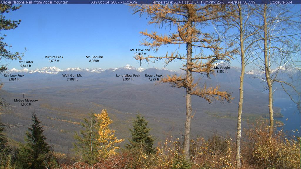
Apgar Webcam Page
Glacier National Park in Pictures
Glacier Mountaineering Society
Logan Pass Trails
Visit Montana