
-
 19539 Hits
-
 84.2% Score
-
 18 Votes
|
|
Mountain/Rock |
|---|---|
|
|
37.09420°N / 105.1918°W |
|
|
Costilla |
|
|
Hiking, Mountaineering |
|
|
Summer |
|
|
13723 ft / 4183 m |
|
|
Overview of Peaks
Most climbers are familiar with at least part of the history surrounding the property around Culebra Peak. They know its private, and they know that until recently the peaks had been closed by the then owner of the land. The new owners, Bobby Hill and family out of Texas, have worked to re-establish climbing access, even going as far as to rename the property Cielo Vista Ranch to break ties with the previous owners and their policies. For a fee, climbers can now climb Culebra Peak and legally and legitimately finish the Fourteeners. For an extra fee, Red Mountain can be added for those wishing to complete the Centennial list as well.But what about the other peaks that are on Cielo Vista Ranch property? In particular, Vermejo Peak (13,723') and Purgatoire Peak (13,676') are Bi-Centennial Thirteeners, the 135th and 160th ranked peaks in Colorado respectively, and anyone with aspirations for finishing that list has one question: Can those be legally climbed as well? The answer I am happy to share with you, is "yes".
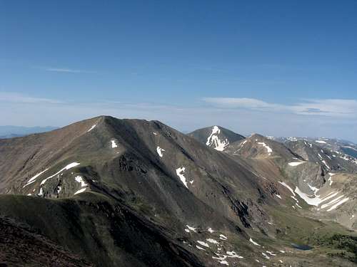
Vermejo is the taller of the remaining peaks on Cielo Vista Ranch, and like its neighbor to the north Red Mountain, is named for the color of its rock. Vermejo translates to "Vermillion", and the orange and red scree on this peak make this an appropriate name. At 13,723' it is Colorado's 135th highest peak. The summit is located 1 1/3 miles to the south of Red Mountain, and rises with 761' of prominence.
Purgatoire Peak is named for Purgatoire Creek on the east side of the range. It is Colorado's 160th highest peak, and stands at 13,676'. It is located 1.85 miles to the south of Vermejo with 849' of prominence. It has the distinction of being the farthest south 13er in the state of Colorado, and lies barely 5 miles from the New Mexican border. There are no higher peaks to the south in the Rockies until you reach the volcanoes of Mexico.


"Alamosito" lies inbetween the two bi-centennials and is 13,466' high. It is the 276th highest peak in Colorado and has 557' of prominence from its parent, Vermejo. Because the saddle is higher on the Vermejo side, Vermejo is its parent despite being closer to Purgatoire. Alamosito gets its nickname from Alamosito Creek and is the first peak you see when entering the basin.
Nearby also exists unnamed 12er PT 12754. With 454' of prominence this peak is Colorado's 817th highest, and can easily be added to your descent if the weather holds. This peak is surprisingly rugged and offers some mild scrambling to its small enjoyable summit.
Red Tape
These peaks are probably most famous for their "red tape". I won't even try and match the wonderful history of the ranch that Grant provided on his Culebra Peak page. Check it out for additional information.For climbing Vermejo, Purgatoire and neighboring "Alamosito" peak, you must first contact Cielo Vista Ranch. The contact information changed in early 2014, and the ranch has set up a new website for booking climbs: Cielo Vista Ranch, at this time it is unsure how they are handling booking for trips to climb Vermejo and Purgatoire peaks. They typically only allow one or two trips up these peaks annually as they are much less popular than Culebra Peak and Red Mountain to the north. The cost for this climb was $150 for all three mountains in 2014, no pricing or schedule has been released for 2015 at this time, contact the ranch for information regarding access.
A minimum of 5 climbers is typically required. The ranch begins taking climbing reservations usually sometime in early May. The date of the climb will likely be in Mid-July, and is subject to the ranch's discretion. Our climb was on July 12, 2008 and we were originally reserved as a group of 7, but two additional climbers were added to our group by the ranch.
In the past the ranch has offered an "all you can climb" special rate, however, in 2008 when I inquired about this deal they said they were not doing so this year. If they allow this in the future, it can be an excellent opportunity to climb these and the other peaks on their property. Not sure if such an opportunity will ever re-present itself, but might be worth an inquiry. We were able to secure reservations for a group to climb the 13ers north of Culebra in 2011, future such trips would be at the ranch's discretion. Interested parties should inquire with the ranch.
As with Culebra and Red, there is NO access to these peaks from the east side of the range.
NOTE: For 2011 the ranch had two planned hikes for these peaks, and will hopefully continue to do so in future years. Please contact the ranch for more information and to make your reservations!
Getting There
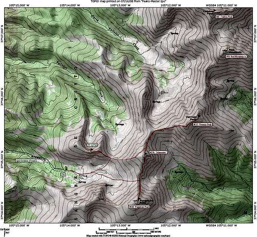
All climbers must first register and pay their fee at ranch headquarters, therefore you must meet the ranch representative at the main gate. This is the same access point for climbing Culebra and Red.From Fort Garland (along US 160 between Alamosa and Walsenburg) travel south on CO 159 to the small town of San Luis. From here, turn left (east) on the P6 road and follow it for 4 miles to the town of Chama. Turn left (east) on the L7 road and follow for approximately 3 1/2 miles and turn right (south) onto the 25.5 road immediately after a bridge. Follow for 1/2 mile to the M5 road and turn left. After just under a mile you will reach the gate.
In order to reach the trailhead for these peaks, the ranch representative will escort you to the south gate and let you into the ranch and give you directions to reach the trailhead. When we climbed these peaks we were escorted back out through the town of Chama and through the nearby town of San Francisco to the gate. From this point we followed the ranch representative to a small parking area at a road junction. Beyond this point 4WD is required to reach the upper trailhead.
The road is rough, but managable in stock SUVs and pickups provided they have 4WD (NOT AWD). The road is rocky and rutted in spots and mostly has been grown over with grass. We followed the left forks along the way, basically paralleling Alamosito Creek on the north side to reach the upper parking in a small log strewn parking area at approximately 11,600'. However, I have been told that the right forks are easier!
In speaking with the ranch manager and people who climbed these peaks in 2011, this year climbers were escorted to the trailhead and that the route has been altered from our climb. Please take the information in this section as a guide only, and to follow the instructions of the ranch manager when you arrive.
Accommodations/ Provisions
For climbers with reservations, camping is allowed at the ranch gates the night before your climb. Other options for camping exist at nearby Sanchez Reservoir. The San Luis Inn offers climbers a special rate when mentioning they are climbing on the ranch for those looking for indoor sleeping options.There is a grocery store in San Luis for all of your food provisions, I did not see a mountaineering/outdoor shop.
There are a handful of small restaurants in both San Luis and Fort Garland as well as gas stations with convenience stores in both towns.
Route Information
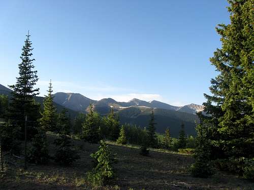
Please note the following description is from our route when we climbed in 2008, according to the ranch manager and people who climbed in 2011, there were some modifications to the route that they did this year. Please take the information in this section as a guide only, and to follow the instructions of the ranch manager when you arrive.Our route climbed these peaks with "Alamosito" from the head of Alamosito Creek. With a climb of PT 12754 our round trip mileage clocked it at around 8 miles and 4500' of climbing. Not bad for four ranked peaks! The high trailhead is essential to success, due to the ranch check-in policies and the fact they do not open the main gates until 6am, it is difficult to start this climb before 8am. In monsoon season that is a REALLY late start!


Our climb started by following along the creek through open trees to a beautiful meadow. Climb to the 12,827' saddle between Purgatoire and "Alamosito" and then ascend the steep grass and talus north ridge to Purgatoire's summit. Retrace your steps and climb the gentler south ridge to the summit of "Alamosito". The route to Vermejo is visible from here. Descend a steep loose step and then continue along the gentle ridge over a few mild bumps to the 12,909' saddle. Ascend the moderate talus ridge to Vermejo's southwestern (false) summit and then traverse to the true summit. It is not necessary to completely reclimb "Alamosito" on the return. There is a nice traverse across a bench at 13,200' that gets you over some nasty scree. Others in our party descended below this scree and across the basin to the NW of "Alamosito", then ascended to the 12,300' saddle between "Alamosito" and PT 12754. For "extra credit" climb the narrow rocky ridge on PT 12754 to its summit, or just descend from this saddle back to the meadow and your vehicles.
See the attached map for additional topographical information. (Click to enlarge)
Conditions/ When to Climb
Contact Cielo Vista ranch for current conditions and information on when the mountain is available to climbers. As of this time, I only know of summer ascents being allowed on these peaks. For weather forecasts check out this link: NOAA Forecast2008 Plane Crash on Vermejo
Unfortunately on the evening of December 20th, 2008 a small private plane crashed into the northeast face of Vermejo Peak, killing both people on board. The plane was spotted by helicopter the next day. Yet another reminder of how precious life is, and how dangerous the mountains can be. Best wishes to the families of those who lost their lives in this crash.A link to the Denver Post article is below.
Plane crash on Vermejo