
-
 19008 Hits
-
 77.79% Score
-
 9 Votes
|
|
Mountain/Rock |
|---|---|
|
|
39.71630°N / 105.4317°W |
|
|
Clear Creek |
|
|
Hiking |
|
|
Fall |
|
|
9568 ft / 2916 m |
|
|
Overview of the Mountain and the trail.
Ever get tired of driving up I-70? Ever get sick and tired of sitting in traffic, going 0-5mph? Ever sit there, right before you go downhill heading west at Floyd Hill and wonder what that peak to your left (south) is, and why you just don't hike that and then go home, avoiding all of this tedious, expensive driving?Well, you can have a small answer. The mountain is Saddleback Mountain, a Clear Creek County ranked peak with 348' of prominence. There are 64 ranked peaks in CCC, and a few people have climbed all of them. Being so tied into the neighborhood, you'd expect access issues, but there is a nice small public trail in Clear Creek County Open Space (CCCOS), which has a terrible website, in case you check.
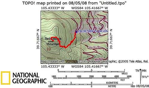
Route from parking area.
The trail can be hiked year-round, but possibilities exist of deep snow in February-April.
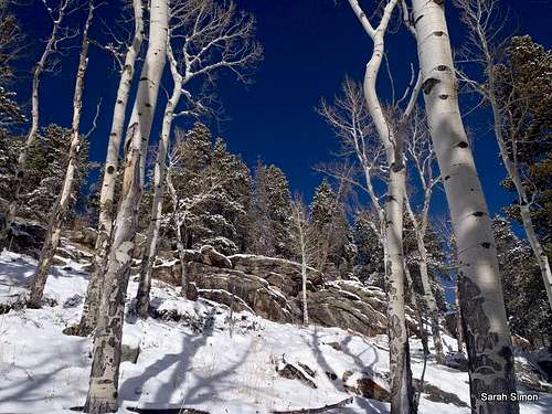
Snow slopes. Courtesy Sarah Simon.
The trail is a simple use trail; that is, it has seen very little in the ways of development. No one went through with picks and shovels and leveled the path. It slopes where the mountain slopes, and simply follows the gradient to the summit. It is lined here and there with the occasional dead tree and cairn to show you the way, but you won't find it in the snow. It wanders nicely through a few aspen groves and back and forth into the pines, teasing you with their fragrance. The last 200 vertical feet it curves around gently to the north side, then curls back to the summit. You can expect to gain about 800' on the trail, and expect something in the vicinity of 2 miles round trip. The summit is a nicely distinct pile of several outcroppings of gneiss. I have not seen a register on this little gem, but maybe someone will install one.
Getting There
To get to the Clear Creek Open Space trailhead take the Beaver Brook exit off of I-70 (exit 248) and head west on US-40 (frontage road) before crossing the highway to the south (left while heading west). Take a right on Saddleback Drive. Follow this as it switchbacks its way up the hill. Continue until you hit Saddle Ridge Drive. Follow this road and at a prominent switchback just below a large white house there is a tiny (2-3 car max) parking area with a sign designating this as Clear Creek County open space. The road dead ends shortly past this switchback, so you will know if you've gone too far.Some parts courtesy of Ryan K.
[img:770206:aligncenter:medium:Start in winter.
Courtesy Sarah Simon]
There is really only 1 main trail to the summit, but part of recent improvements seem to be small little spur trails that give a couple of options for steepness and adding a bit of length. Going uphill, both right hand trails are steeper and shorter. The left hand trails are slightly mellower and not as steep, but a bit longer. Makes a nice loop to go up both right hand trails to reach the summit, then continue past the summit, after touching it of course, north and follow the trail as it heads west and back down, eventually meeting up with the steeper trail. Makes it a bit of a double-bubble loop hike while still ascending and descending most of the same trail.
Red Tape
Biggest red tape would probably be the extremely limited parking - there is only room for 2-3 cars at best in summer, fewer in winter.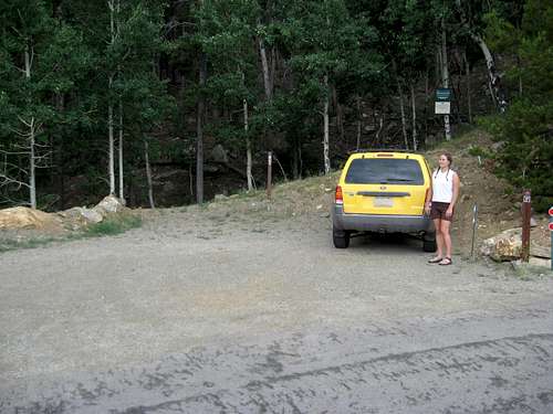
Summer parking.
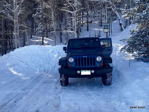
Winter parking. Courtesy Sarah Simon.
Camping
There is no camping available anywhere near this TH and peak. The nearest camping might be in Golden Gate Canyon State Park, or some of the camping that can be reserved at White Ranch Open Space Park (Jefferson County). There is also some "camping" available in some "campgrounds" (re: trailer parks), but I shudder to think of those. There is one of them in Golden, just off of Clear Creek at the west end of town.Really, though, there are better places and peaks for camping. This peak is more of a metro Denver day-hike.
External Links
Peak Info on listsofjohn.comCCCOS
Sarah Simon - Jan 9, 2012 1:06 pm - Voted 8/10
Winter PhotosJeremy, I've added a few winter photos to this mountain page. Feel free to include them in the page content if you so desire. Sarah
Jeremy Hakes - Jan 11, 2012 10:42 am - Hasn't voted
Re: Winter PhotosDone!
Steven Cross - Jun 10, 2012 2:01 am - Voted 10/10
Trail being improvedCCCOS is improving this trail. They are laying logs along the trail. They have finished laying logs down to a junction. Not sure where the other trail leads, I suppose it's another trail head. I added a photo of stacked logs which they are using to improve this trail.
Jeremy Hakes - Jun 28, 2012 2:15 pm - Hasn't voted
Great! Now...I hope they build a connector trail over to Sante Fe Mtn!
Steven Cross - Jul 13, 2012 5:53 pm - Voted 10/10
Re: Great! Now...If they did that I'd be obligated to go and hike it. That would be cool.