
-
 19060 Hits
-
 92.85% Score
-
 40 Votes
|
|
Mountain/Rock |
|---|---|
|
|
49.94436°N / 125.81331°W |
|
|
Hiking, Mountaineering, Scrambling |
|
|
Spring, Summer, Fall |
|
|
6056 ft / 1846 m |
|
|
Overview and History
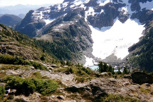
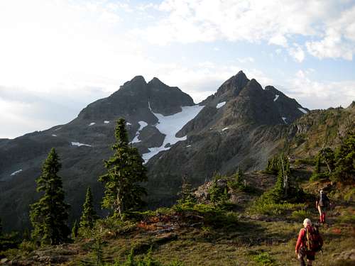 Crown Mountain from the north ridge approach Crown Mountain from the north ridge approach |
Situated in the extreme northeast corner of Strathcona Provincial Park, and above the valleys of the Salmon River to the west and Crowned Creek to the east, Crown Mountain stands high above any of its nearest neighbours and its twin summits present an eye-catching spectacle from several points along the Island Highway 19 north of the town of Campbell River.
Only as recently as the late 19th century, very little was known about the interior topography of Vancouver Island. This changed significantly in 1896 when the Bolton/Laing expedition traversed the interior of the Island on foot or by water from Alert Bay in the north to Port Alberni in the south which, at the time, defined the northern limit of exploration of the Island’s interior. The expedition’s course took it through a good deal of the alpine backbone of the north Island until, about a month after setting out the group arrived at a point where “We could see peaks without number…..and a mighty mountain with two towers……we judged the towers to be 8,000 feet high”.
Bolton was writing, in fact, about the Golden Hinde and its neighbour to the west, the Behinde. The group was, indeed, amongst the highest and most spectacular alpine scenery on the Island.
From this point the expedition’s course took it to what Bolton called “Balloon” and “Ice” Lakes to the east of the Hinde and thence down the “Mosquito River” to Buttle Lake. Today these features are known as Burman and Schjelderup Lakes and the Wolf River respectively.
After building a raft to negotiate Buttle Lake (and after re-supplying) the expedition travelled south along Flower Ridge, down to Margaret Lake and on to Drinkwater Creek, Great Central Lake and finally, two months after starting out, to Port Alberni.
This astonishing journey, in a time of no roads and with only minimal foreknowledge of the terrain around them, has never been repeated.
Bolton wrote extensively on his journey in the ensuing years and one of his most avid readers was Sir Richard McBride the premier of the fledgling province of British Columbia. McBride had become interested in establishing a park in the province as a result of encouragement from Earl Grey, then Governor of Canada and by 1909, and mostly as a result of Bolton’s glowing reports, had decided that it would be on Vancouver Island.

1910 Climbing party

Myra Ellison
Government enthusiasm for the new park was high and only a month after its proposed incorporation the Minister for Lands, Price Ellison, decided that he would go and see the area for himself.
“The Chief” as he was known took a large party of 23 by steamer from Victoria to Campbell River on July 7, 1910. Amongst the party was the Chief’s daughter, twenty year old Myra, Colonel William Holmes, a Provincial Land Surveyor, Harry McClure Johnson, the Chief's nephew and, as historian and guide, the same William Bolton who had traversed the Island nearly 15 years previously.
Since it lay at the northern apex of the park, Crown Mountain was selected as the expedition’s first objective.
To this end a base camp was established on Upper Campbell Lake and a climbing party of nine selected to find and attempt a route to the summit. The party left their base camp on July 24 and took 4 days to traverse several drainages to the west to a point from which they felt the summit could be attempted.
On July 29 the party climbed Crown Mountain by the east ridge, the only difficulty being a bluff 400 feet below the summit which was by-passed by means of a convenient snowfield. None of the party was accustomed to climbing snow and the photograph of them doing so is full of tentativeness and trepidation and has become a historical treasure amongst Island alpinists, not the least reason for which is that Myra is wearing a skirt!
On the summit the group built a cairn and placed in it a brass cartridge in which was recorded the statement.
“Crown Mountain.
Ellison Peak,
Friday, July 29th, 1910
A party of the Provincial Government Expedition, headed by the Chief Commissioner of Lands, the Hon. Price Ellison, M.P.P. for the Okanagan District, and organized for the purpose of exploring the region surrounding Crown Mountain and Buttle's Lake with a view of setting aside the same as a Provincial Park, reached the summit this day, at 7:45 a.m. Miss Myra King Ellison, the Chief's daughter, was first to reach the topmost point, and there waved the Union Jack. The party ate lunch. Then at 8:23 o'clock, with the words, "I hereby name you Ellison Peak, Crown Mountain." Miss Ellison broke a bottle of Champagne over a cairn of rocks erected by the party, at the same time the Union Jack over the Star Spangled Banner of the United States being held above her head by the Chief. Then the Chief led in singing, "God save the King," and H. McC. Johnson in singing the first verse of "My Country, 'Tis of Thee."

East ridge snow in 1910
Sadly no trace of this famous artifact has survived.
After returning to camp and re-joining the rest of the party, the expedition proceeded a few days later to Buttle Lake, south up the Price Creek valley, over Price Pass and down to Margaret Lake where they joined Bolton’s route out to Great Central Lake and Port Alberni.
The expedition was adjudged a huge success and with the Minister for Lands as its most effective proponent, plans were soon afoot to develop Strathcona as an alpine resource along similar lines to those adopted in the Rockies and in Europe. Roads were planned and surveying initiated with great enthusiasm. Everything, however, came to a grinding halt with the outbreak of the First World War in 1914.
Although some resources were eventually developed, Strathcona to this day remains principally an area of untrammeled and pristine wilderness.
Those of us that love the Park are grateful simply for its continued existence in the midst of the industrial carnage that encroaches upon it from all directions. Pressure to log and mine within the Park by modifying its boundaries is unrelenting and requires constant vigilance by all parties interested in preserving the values that the Ellisons and their colleagues saw nearly a century ago.
Price and Myra’s enthusiasm can still be felt and is enormously valued by modern alpinists. Without their ascent of Crown Mountain and subsequent progress through the area, Strathcona may well be a shadow of its current self. A trip to Crown Mountain today is almost as much a pilgrimage as it is a climb.
Like all real pilgrimages expect to suffer a little in order to attain your goal.
There is no trail up Crown Mountain. There is no trailhead. There is only minimal route marking. A total ascent of almost 2,500 metres is required to reach the summit and return even though it’s only a net 1,200 from the highest point to which you can drive. Only those with well honed wilderness navigation skills with map and compass and/or GPS should attempt this climb.
There is, however, compensation in abundance for such perceived hardships. Once you’re above the (admittedly ugly) second growth, the way lies through lovely and open old growth with scarcely a trace of the thick bush so common on the Island. Such untouched forest is likely exactly as the explorers saw it. Once above the big trees, glorious alpine ridge hiking leads to summit routes that are challenging without being difficult. Above all, you get to see what Myra, Price et al saw and to realize at first hand what infected them with a love for the area that abides in others to this day.
The summit of Crown has a hydrographic tripod, a cairn and a summit register. Since the summit register was put in place in 1986, there have been just 16 ascents, 2 of them this year (2008) including our own.
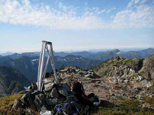
The summit of Crown Mountain.
Getting there and initial approach
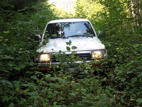
Vancouver Island can be reached by air from Toronto, Vancouver, Seattle, Calgary and Edmonton to Victoria, Nanaimo, Comox or Campbell River and by ferry from Port Angeles to Victoria on The Coho and on BC Ferries from Vancouver to Victoria or Nanaimo. Public transport on the Island is notoriously poor and anyone arriving by air would be advised to rent a car.Access in this case involves steep, rough, de-commissioned logging roads. A 4WD vehicle with high clearance is essential in order to reach the very top of the road that gives access to the mountain. Chains may also be required if the roads are still under snow. This can occur well into May.
From any point on southern Vancouver Island, drive north on the Island Highway 19 to Campbell River and beyond in the direction of Port Hardy.
 Driving SF900 | 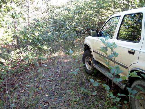 End of SF900 |
If you haven’t already done so, lock in 4WD drive here. Drive 1.7 km round the toe of the ridge and up the west side of the Crowned Creek valley to the point at which SF 900 ends in an alder thicket at N50° 00.573 W125° 46.344. The road is rough and becoming choked with alder. Put a saw in the truck in case you need to cut your way through. Starting elevation here is 620 metres.
Approach
SF 900 has been debuilt beyond the point described above but a faint path can still be followed along the bench above Crowned Creek that it once occupied. Proceed along the path for 15-20 minutes to N50° 00.285 W125° 46.561 and the site of an old, partly collapsed helipad.Head straight uphill from here up a steep, loose gully into a horrible combination of old logging slash and immature second growth. Make your painful way to the neighbourhood of N50° 00.296 W125° 46.685 where the mature forest begins.
Animal trails and flagging head up generally SW and very steeply from here. This is the first time I’ve seen a spot where even the animals have made a contoured route! With a full pack, this short section is a chore. The steepness eventually relents, however, and flagging leads to a second, higher – presumably heli-logged - clearcut.
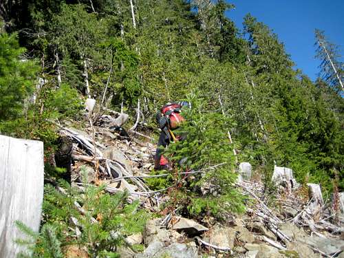 Old Slash and immature second growth | 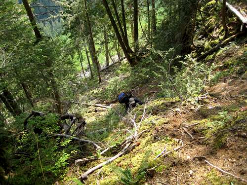 Into steep old growth | 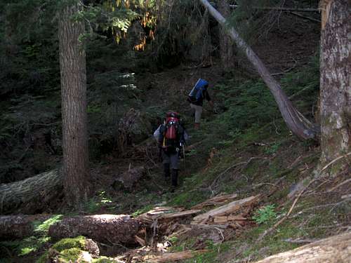 Negotiating Bluffs to the north ridge proper |
Find a steep but reasonable gully on the left of the bluffs and go up it and onto the ridge crest.
From this point it is just a matter of making the best route south along the crest keeping a careful eye on the GPS/compass. The occasional “comfort” flag may be spotted that offers assurance that you’re still on route, but don’t count on it. Although the ridge is heavily forested this is mature old growth with very little undergrowth to impede progress. Water is available at only one spot prior to reaching the alpine at a rather weedy tarn at N49° 59.373 W125° 47.681.
Eventually, about 5-6 hours from the start, the ridge breaks out of the trees and onto an open bluff at N49° 58.545 W125° 47.921 from which the route ahead can be seen for the first time. Due south of your position and across a forested saddle, the ridge crest can be seen breaking out onto open heather slopes.
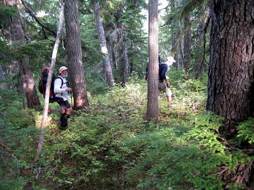 Open Old Growth | 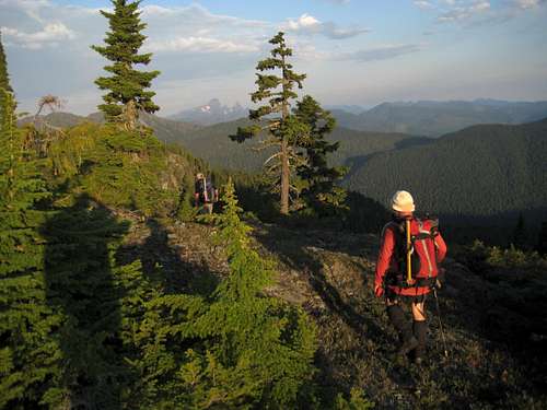 Into the alpine on the North Ridge | 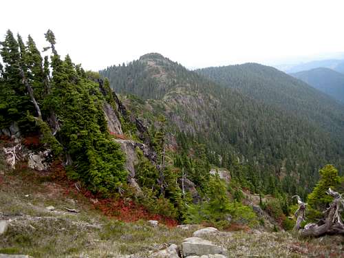 Peak 5412 |
A Mapsource GPS tracklog is available for the approach route described above. Simply email or send me a PM.
Crown on the final approach
Summary of Summit Routes
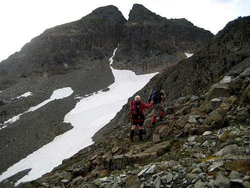
North Glacier/NW Gully; AI1/3rd Class, 200 metres.East Ridge; 3rd Class, 300 metres. The original 1910 ascent route. Approach by traversing east across the north glacier.
North Ridge; 4th Class, 150 metres. Approach by east traversing across the north glacier.
“The Cleft”; AI1, 75 metres. Early season/winter route. Climbs the narrow snow gully from the bottom of the north glacier almost directly to the main summit.
Red tape and safety considerations
Absolutely no red tape.There’s nothing resembling a trailhead and an intentions system simply doesn’t exist in this neck of the woods. Make sure, therefore, that you have left a detailed trip plan with someone responsible. The RCMP and the appropriate SAR agency will respond in an emergency but it is up to you to have the mechanism in place that will initiate the call-out process if it becomes necessary.
Although we were able to obtain strong signals on two cellular phones (Telus and Rogers) calls would not connect. Be prepared, therefore, to be totally self-reliant or to consider the necessity of a satellite phone if you are not comfortable with this.
Camping
Glorious camping anywhere at and above the first tarns as described above. Fires are strictly prohibited and you must pack a stove.Bear and cougar frequent the mountains and forests of Vancouver Island. Big animal scat and tracks are everywhere you look in this area. Proper back country methods – hanging food bags out of reach, cleaning up all cooking scraps, good toilet practice etc – are absolutely essential. Giardia is well documented throughout the Island, so boil or treat all water.
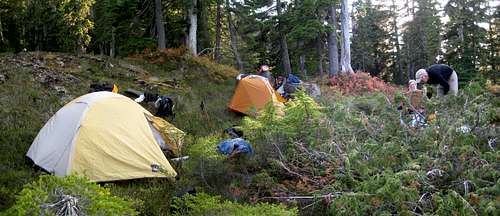
North ridge camp
Weather
Nearest point current conditions and forecast.OR
Additional Information
The correct map for this trip is the government 1:50 000 topographical map sheet 92F/13, “Upper Campbell Lake”. Advance copies can be ordered on-line at this link. Copies are usually readily available in good bookstores and outdoor stores throughout the Island.Suggested Reading
Lindsay Elms’ historical treatise on the mountains of Vancouver Island should be considered essential reading before any trip into Crown Mountain. Visit his Beyond Nootka site in general and the Crown Mountain page therein in particular.Island Alpine – A Guide to The Mountains of Strathcona Park and Vancouver Island, Philip Stone, Wild Isle Publications, 2003, ISBN 0-9680766-5-3 and/or visit Island Alpine Climbing Guide
An excellent guide to the back roads of Vancouver Island is Backroad Mapbook. Volume III: Vancouver Island
Historical Glossary
The role played by many parties in the events leading to the first ascent of Crown Mountain and the subsequent creation of Strathcona Provincial Park is commemorated in many permanent place names.Price Ellison’s name lives on in his route up the Price Creek Valley and over Price Pass to Margaret Lake – the name of Richard McBride’s wife.
Myra Ellison is with us every time we climb Mt Myra at the south end of Buttle Lake adjacent to Price Creek.
 Price Pass from Flower Ridge |  Jocelyn Hill and Holmes Peak |  Mt Myra | 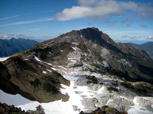 Mt McBride |
In the Gowlland Range, close to Victoria is William’s namesake Holmes Peak
Rather strangely there are no mountains or rivers named after either Bolton or Laing. There is a Mt Laing above the Cervus/Wolf divide but this is named after a Comox naturalist of this name. Perhaps a relative?
Crown Mountain Summit Panorama
  |