
-
 44029 Hits
-
 87.76% Score
-
 25 Votes
|
|
Mountain/Rock |
|---|---|
|
|
48.33124°N / 114.08149°W |
|
|
Flathead |
|
|
Hiking |
|
|
Spring, Summer, Fall |
|
|
7234 ft / 2205 m |
|
|
Overview
Layout designed for best viewing on a "1024 x 768" screen.  |
|---|
Columbia Mountain lies just east of the city of Columbia Falls in Flathead County Montana. Columbia Mountain is the northern terminus of the Swan Range. Columbia Mountain stands at 7,234 feet tall. The Alpine Trail #7 starts at this mountain, the trail runs along the Swan Range Crest for over 50 miles. It goes past many lakes and extraordinary alpine areas. This trail also passes through the Jewel Basin Hiking Area.
Fire History
The Half Moon Fire had first started west of the town of Columbia Falls in 1929. It had swept across the mountains into Glacier National Park. It burned 103,000 acres in just three days. It made a 30 mile swath that had cut across the two mountains, Columbia and Teakettle, then across the Flathead River, into the canyon and onto Apgar Mountain.
Getting There

Columbia Mountain
As mentioned earlier Columbia Mountain is located just east of Columbia Falls. There is an unmarked road on the right, just past the House of Mystery on Highway 2. It is bordered by forest service land. Turn here and drive a short distance to the trailhead on the left.
Directions from Montana Vortex and House of Mystery:
https://goo.gl/maps/YRRaim1X8K7XaEjM7
Red Tape
Columbia Mountain is located in the Flathead National Forest. This is bear country, so hike with bear spray and make lots of noise.
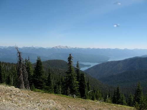
Summit Views
 |
 |
|---|
The summit views are great when it's not a hazy day. There are good views of Great Northern Mountain, Flathead Valley, Glacier National Park, North Fork Country, the Bob Marshall Wilderness, and the beautiful Whitefish Range.
 Great Northern Mountain and the Hungry Horse Reservoir
Route Information
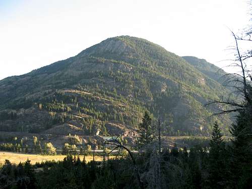
Teakettle Mountain

Columbia Mountain water source.
You should be in good physical condition before hiking this mountain. This is a brutal trail with a 4,000 feet elevation gain and a total round trip of 12 miles. There is also an elevation loss of several hundred feet in the first 2 miles and then that elevation loss is regained fairly quickly. So you are talking about a total elevation gain/loss of close to 9,000 feet in this round trip.
There are several water sources on this mountain. The last water source is about 2 miles into the hike. At the last water source there is a trail going up to a double waterfall about 200 yards directly up the mountain off of the main trail.
 Last water source |
 View to the summit ridge View to the summit ridge |
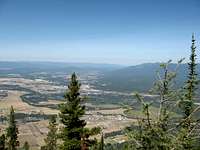 Columbia Falls Flathead Valley |
After this water source the trail starts getting rocky and it starts getting narrower. Along the trail there is an excellent camping spot, which is good for a break. There is lots of loose rock on the trail, but there are plenty of outcroppings along the trail. You are on one side of the mountain until you get onto the ridge. Until you are on that ridge you have excellent views of the Flathead Valley and Teakettle Mountain, but make sure to do this mountain on a non-hazy day and when its not hunting season. Columbia Mountain can be a popular hunting area and accidents can happen. From what my friends have said about Teakettle Mountain, Columbia's neighboring mountain, is a rough climb. Teakettle has incredible cliff faces all over it. It is in a separate range called the Whitefish Range and Columbia is in the Swan Range. Once you gain the ridge on Columbia Mountain you come to a fork. On your right is the Alpine Trail #7 and on your left is the Columbia Mountain summit. You will know when you are on the summit because there is a large cairn. At the summit you come to views of Glacier National Park, the northern end of the Bob Marshall Wilderness, the Flathead Valley, and the North Fork Country.
Equipment
In addition to Bear Spray bring: Water or a container to fill with water at some of the water sources. A filter is recommended. Also a hiking backpack of some sort and some fairly good footgear.