
-
 20044 Hits
-
 90.47% Score
-
 32 Votes
|
|
Mountain/Rock |
|---|---|
|
|
39.09890°N / 105.0594°W |
|
|
Teller |
|
|
Hiking |
|
|
Spring, Summer, Fall, Winter |
|
|
9363 ft / 2854 m |
|
|
Overview
Profile image courtesy of Jeremy Hakes.Sandwiched between Hwy 67 to the west and Rampart Range Road (FR 300) to the east, Mount Deception provides for a pleasant day outing to those in the greater Colorado Springs Metropolitan Area as well as those in southern Denver. Its slopes are heavily wooded, rocky and free from the burden of developed trail (though hints of a climbers’ route will be apparent to the astute hiker on the eastern slopes). Views from the sparsely-wooded summit are not wide open, but nonetheless worth the climb. Summit vistas include a tree-framed look at Devil’s Head and a fantastic, broad-side view of Pikes Peak and Almagre.

Pikes Peak beyond the rocky eastern slope of Mount Deception.
16 Nov 2008
Colorado Rank: 2,693rd highest mountain in Colorado
Prominence: 463
Mountain Range: Front Range
USGS Quad: Mount Deception
Trails Illustrated Map: #137 (Pikes Peak, Cañon City)
Rank and Prominence Reference: Lists of John
Getting There
Click iamge to enlarge
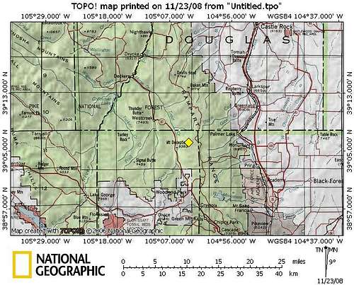
Mount Deception rises in the far northeast corner of Teller County, about 8 miles north of Woodland Park, Colorado, via Rampart Range Road (FR 300) or 5 miles north via Hwy 67. Woodland Park, 18 miles from Colorado Springs, is the nearest sizable town to Mount Deception, providing gas, restaurants, a grocery store and more.
Rampart Range Road (FR 300) is a well-maintained dirt road that runs north-south at a general elevation of about 9,000 feet from Hwy 67 to the north, south to Garden of the Gods in Colorado Springs. Hwy 67 is a paved Colorado throughway. Ultimately, how you get to Mount Deception depends on where you start. There are many ways to get here.
Route Overview
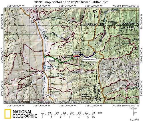
Click image to enlarge
| Route | Mileage | Elevation Gain | Special Note | Driving Directions |
|---|---|---|---|---|
| Summer Eastern Slopes | .6 miles roundtrip | 416 ft. | The shortest, most direct route with least elevation gain | From Rampart Range Road, go west on Hotel Gulch Road about 1.5 miles to a non-descript turnoff to a casual camping area and park. (Campsite turnoff is at the highpoint of the road between 2 streams indicated on the map.) |
| Shoulder Season from Rampart Range | 3.6 miles roundtrip | Net loss of 19 feet (includes 352 feet of climbing and 371 feet of descent to reach summit) | A good option when Rampart Range Road is open but Hotel Gulch is impassible due to snow/mud. | From Rampart Range Road, go west on Hotel Gulch Road. |
| Winter from Hwy 67 | 4.7 miles roundtrip | 1,602 ft. | Longest route with most elevation gain; suitable when roads to other routes are impassible | From Woodland Park, follow Hwy 67 about 5 miles north to Rt 79 turnoff. Turn east. Hotel Gulch Road will be on your right. |
Camping & Lodging
CAMPINGRustic camping in “unofficial” campsites is available throughout the Rampart Range Road area, right off the main road and spur dirt roads off of it. Most notably, there is a pleasant (albeit dry) campsite right at the eastern foot of Mount Deception. These campsites are available on a first-come, first served basis and provide no services (they are entirely rustic). Most are dry campsites and will require water to be hauled in for cooking and bathing.
Be forewarned that the proximity of this area to the urban I-25 corridor means that crowding can be an issue, especially in the summer, and that unsavory characters are known to frequent this area. Be prepared for heavy ATV use, large crowds, drunkenness and casual firearms usage.
The National Forest Service operates three general-use campgrounds in its Manitou Park Recreation Area. The Manitou Park Recreation Area is located about 5 miles north of Woodland Park along Hwy 67. Below is information about these campgrounds as provided by the Forest Service.
South Meadows Campground: Site has 64 camp sites with parking areas up to 30' long within the 8,000' elevation. Camping season is year round with a user fee of $15.00/per night/per site. The camp-ground has paved roads. Limited sites are reserved by calling 1-877-444-6777. Reservations may be made 240 days prior to arrival and there is a reservation fee. There is also a 2-night minimum stay if your reservation is for Friday or Saturday nights.
Colorado Campground: Site has 81 campsites with parking areas up to 30' long within the 7800' elevation. Camping season usually begins late May and runs until early September. The user fee is $15.00 per night/per site. This campground has paved roads. Limited site reservations can be made 240 days prior to arrival by calling 1-877-444-6777. There is a reservation fee. There is also a 2-night minimum stay if your reservations are for Friday or Saturday night.
Painted Rocks Campground: Area has 18 campsites with parking areas up to 30' long within the 7800' elevation. Camping season usually begins in May and runs through early September. A user fee of $13.00 per night/per site is charged. Limited sites are reserved by calling 1-877-444-6777 and can be made 240 days prior to arrival. There is a reservation fee.

Pikes Peak and Almagre from near the summit of Mount Deception
16 Nov 2008

Devils Head from near the summit of Mount Deception
16 Nov 2008
HOTELS
A few simple hotels (many family-run) are available in Woodland Park (elevation 8,465 feet) along with several RV sites and cabins.
For more information visit The Greater Woodland Park Chamber of Commerce Visitor Information page.
Red Tape
There are no user fees to access this area and no permits are required, nor are any special regulations placed upon climbing this formation.- Do not litter and dispose properly of human waste.
- Much of Rampart Range Road is a “no shoot” zone. That means: Shoot only in designated target ranges.
- Operate motor vehicles only on designated roadways.
- For everyone’s safety, the National Forest officials segregate street legal, licensed motor vehicle traffic from OHV traffic. Adhere to posted placards managing this traffic. (In plain English: Keep your Jeep off the trails and keep your dirt bike / quad runner off the roads.)

Humble summit cairn of Mount Deception
16 Nov 2008
Weather & Seasons
The summit of Mount Deception can be enjoyed year-round. The relatively dry Rampart Range area receives modest snow (compared to the Colorado high country) and the gently-sloping, wooded flanks of Mount Deception do not qualify as primo avalanche terrain.When little or no snow is on the ground, reaching the summit of Mount Deception can be short, pleasant jaunt with little elevation gain (if you let your 4x4 do most the work). In the winter, however, snow-packed 4x4 roads mean the mileage to the summit must be covered by foot. Furthermore, if Rampart Range Road (FR 300) is closed for the season, the mountain must be accessed from Hwy 67. The access point from Hwy 67 sits about 1,300 feet lower than the access point from Rampart Range Road (FR 300).
 | •IMPORTANT: This section of FS 300 (Rampart Range Road) is closed from roughly 1 December through 1 April annually. Exact closure dates can vary year-to-year, so please check with the Forest Service (Pike National Forest) prior to heading toward “Parachute Rock” during the transition period. •During the summer months and into early fall, the Rampart Range Road area is very, very busy. It is a popular area for OHV enthusiasts and target shooters. While “Parachute Rock” is relatively secluded in its own little nook, expect to climb with the background noise of ATVs and live fire. •In the fall, the days would be cooler and crisp, the aspen turning golden and the likelihood of afternoon thundershowers decreased significantly. |  |