
-
 9648 Hits
-
 86.37% Score
-
 22 Votes
|
|
Mountain/Rock |
|---|---|
|
|
47.42716°N / 10.72386°E |
|
|
Hiking, Skiing |
|
|
Spring, Summer, Fall, Winter |
|
|
7680 ft / 2341 m |
|
|
Overview
 Plansee
 From Plansee lake
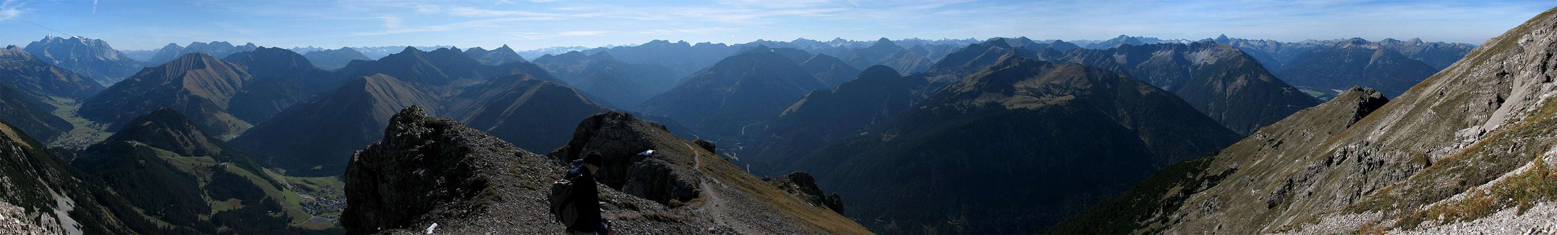
Because of its location, Thaneller is a magnificent view point and very popular. The views to the east and west are dominated by the rocky mountains of the Lechtal Alps and Wettersteingebirge. To the north the mountains become more gentle and get lower and lower. This creates a beautiful frame for the fjord-like Plansee, a lake which is quite nearby and makes the panorama from Thaneller very special. In contrast to the other directions, the view to the south provides a glimpse of the glaciated peaks of the alpine central-ridge with Wildspitze being the highest mountain visible.
As said before, the mountain is visited frequently and if the weather is nice, you have to leave the summit a bit to find a place to sit. As on many other popular peaks there are two things to do to avoid the crowds: start early and go fast to be ahead of the others. While resting at the summit you have to take care of your food, since lots of alpine coughs are waiting for their chance to get a bit of it...
Panoramic View
  |
Routes Overview
|  ascending... ascending... |
Mountain Conditions
 Winterly view
Weather
- www.wetter.at [Berwang]
Long term, but sometimes inaccurate weather forecast for the village of Berwang. - ZAMG
Not as detailed as the link above, but quite accurate forecasts. - OEAV weather forecast
Weather forecast especially for mountaineering porpuses. Unfortunately this page is available in german only. - Avalanche report (Tyrol/Austria)
This german internet page offers the current avalanche report for Tyrol. A link to the current avalanche report in english (pdf document) is on the left side.
Webcams
- http://livecam.feratel.at/cam/berwang/5515/index.jsp
Webcam at Heiterwanger Hochalm (top station of Berwang ski-area). Thaneller itself isn' t visible, but a good view to check the conditions.
Getting There
 Berwang
By car
The trailheads are easily reached by the road 179 connecting Reutte and Ehrwald. From Ehrwald you have access to Garmisch-Partenkirchen (Germany)/Innsbruck (Austria) and the Fernpass. From Reutte you have a good connection to southern Germany.By train
The Ausserfernbahn connects Garmisch-Partenkirchen with Reutte and stops at Bichlbach and Heiterwang. From Bichlbach you have a bus connection to Berwang but I don' t know when the bus leaves (I suppose its not too often). For more information about train and bus connections visit www.bahn.de or www.oebb.at.Red Tape
There are no permits, fees or seasonal closures. Parking at the trailhead at Moos (southern route) is free. I don' t know if there is a parking lot at the trailhead of Werner-Rietzler Steig.Camping
There is no hut directly on the monutain. Camping on the mountain is possible, since there are several spots to pitch a tent on the southern slopes of Thaneller. Views from there during sunset must be great!The area around Reutte and especially around Ehrwald (only some km away) offers several places to stay. For more information check out the links to the hmepages of theses areas in the External Links section.
When To Climb
Thaneller si climbed all the year. The southern route is more crowded and very hot in summer. But it is quite warm and may offer a snow-free ascent even early in winter. I' ve heard that the common ski-route is along the Thanellerkar up to the saddle between Thaneller and Rintljoch (2166m/7106ft).Maps And Books
| Alpenvereinsführer - Lechtaler Alpen alpin Dieter Seibert Bergverlag Rudolf Rother ISBN: 3-7633-1268-4 | Guide book of the hole Lechtal Alps group. The book includes the most common ascents to Thaneller. |
| Lechtaler Alpen Hornbachkette KOMPASS ISBN: 3-85491-025-8 | 1:50 000 map of hole Lechtal Alps group. The Werner-Ritzler Steig route isn' t completely visible on the map. The can be bought at http://www.kompass.at/produkte/alle_produkte/product-detail/wk-24-lechtaler-alpen-hornbachkette/. |
External Links
- www.reutte.com
Multilangual homepage of the area around Reutte - www.ehrwald.com
Multilangual homepage of the area around Ehrwald. - www.bahn.de
Information about german train connections. - www.oebb.at
Information of austrian train connection.