
|
|
Mountain/Rock |
|---|---|
|
|
57.59194°N / 5.5723°W |
|
|
Hiking, Mountaineering, Scrambling |
|
|
Spring, Summer, Fall, Winter |
|
|
3235 ft / 986 m |
|
|
Introduction
Beinn Alligin is the name given to the small collection of peaks located to the western boundaries of Torridon and to the north of the shores of Upper Loch Torridon. The peak is one of the three famous Torridonian groups of peaks, the other two being Beinn Eighe and Liathach. It is suggested that first time visitors to Torridon should attempt the traverse of Beinn Alligin first as it is less complex than its two neighbours, although to suggest that it is worthy of your attention only as an introduction/preperation for other peaks would be somewhat demeaning, as this is a truly splendid peak in its own right.
Torridon is a truly beautiful glen that has been described as 'exhibiting more of mountain beauty than any other district of Scotland, including the Isle of Skye'. The peaks here are among the oldest peaks to be found in the whole of Europe, being some 2500 to 3000 million years old, and are formed by red Torridonian sandstone with some being draped in a covering of white quartzite.
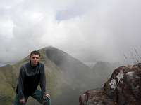
Beinn Alligin is best viewed from the south on the road connecting Torridon and Shieldaig. From this vantage point the entire topography of this mini range can be seen to good example, with the interesting features of the Eag Dubh (Black Cleft) and Na Rathanan (Horns of Alligin) clearly visible. The Eag Dubh is a large section of the cliff face on Sgurr Mhor that at some point in time gave way to the forces of gravity. This section plunges some 550m down towards the floor of the corrie, Toll a'Mhadaidh, which is littered with gigantic boulders. The Horns of Alligin are a group of three rocky pinnacles that give no real difficulty, although are narrow and exposed in places with sensational drops to their eastern side. These can be avoided via a path that skirts along the western sides. There are two easy winter climbs recorded on the horns. The first, Deep South Gully - 250m Grade 1, is in the deep gully between the first and second horns. The second, Deep North Gully - 250m Grade 2, is in the other deep gully between the second and third horns.


The peaks that make up Beinn Alligin (Translation: Jewelled Hill), (Pronounced: Byn Aaleegin) are;
Sgurr Mhor - Translation: Big Peak, Height: 986m/3235ft
Tom na Gruagaich - Translation: Hill of the Damsel, Height: 922m/3025ft
Meall an Laoigh - Translation: Round Hill of the Calf, Height: 890m/2920ft
Na Rathanan or The Horns of Alligin - Height: 866m/2841ft
The names Jewelled Hill and Hill of the Damsel among the translations give the feeling that Beinn Alligin has a somewhat feminine feel to it. Confirmation of this is only a short approach walk away, when once upon her, a true appreciation of her graceful curves and beauty will leave you in awe.
The peaks can be accessed via 2 stalkers paths that are located at the car park next to the bridge over the Abhainn Coire Mhic Nobuil. This can be found on the road that connects Torridon with Alligin. Each of the stalkers paths gives a route for a full traverse over Beinn Alligin, either clockwise or anti-clockwise. The anti-clockwise route (I used this one) scales the Horns first and the initial steep stages of this would be difficult in descent. The clockwise route climbs up through Coire nan Laogh, which is quite badly eroded in the latter stages. The latter route also supposedly offers the best lighting opportunities for photography.
The full traverse of Beinn Alligin should take the average person between 5 and 7 hours to complete.
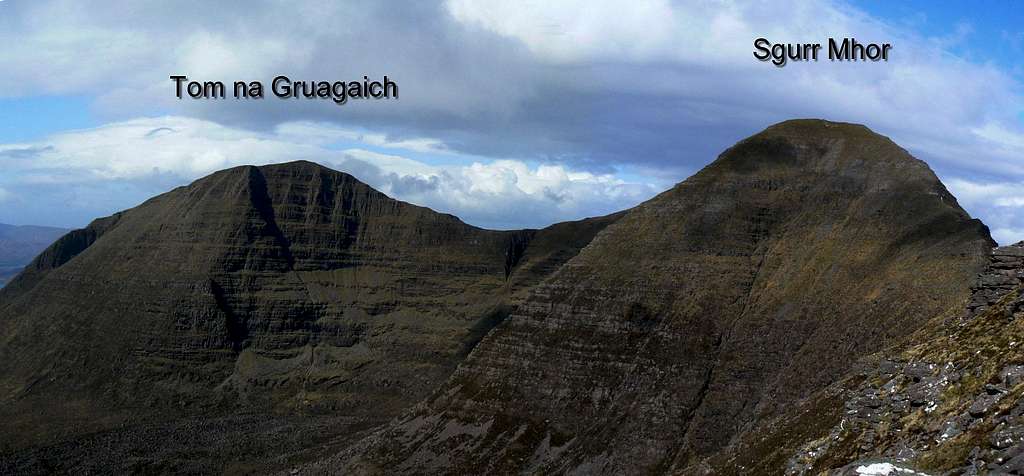
Beinn Alligin's 2 Munro peaks of Tom na Gruagaich & Sgurr Mhor. (Photo by Boydie)
Getting There
AIRPORTS
For arriving in Scotland and making your way to Beinn Alligin in Torridon, the best airports to arrive in are;
Inverness Airport
Edinburgh Airport
Glasgow Airport
Aberdeen Airport
Inverness Airport is the closest to the peaks of Torridon, a mear 50 miles away. Here are a few links for rental car companies should you require this service; Arnold Clark, Easy Car, Hertz
CAR
Car is really the best option for transport to and around the Torridon region. There is public transport available, however it is slightly limited.
From Glasgow take the M80 Stirling road until becoming the A9 road to Perth. From Edinburgh take the M90 road to Perth. From Perth follow the A9 road all the way to Invernaess.
From Inverness take the A835 signposted Ullapool. Follow until turning slightly left onto the A832 signposted Gairloch. Follow for around 25 miles until reaching Kinlochewe. Turn left onto the A896 to enter into Glen Torridon.
Detailed car directions can be inputed and given on the following website; AA Route Planner


BUS
Citylink buses run from Glasgow, Edinburgh and Inverness to Ullapool. It will be necessary to get off the bus prior to Ullapool. Any further travel will require the use of a Postbus service ran by the Royal Mail. This runs from Monday to Saturday.
TRAIN
Trains are available from all major cities and towns. Trains should be taken to Inverness. From here another train to Kyle of Lochalsh can be boarded. There are various stops in the vacinity of Torridon, but further transport will be required to reach Torridon itself. Train timetables can be found at Scotrail.
Red Tape
There is no red tape in Scotland due to the Land Reform (Scotland) Act 2003 which incorporated the Scottish Outdoor Access Code. This code, which commenced on the 9th of February 2005, has established statutory rights of access to land and inland water for outdoor recreation.
The Land Reform(Scotland) Act 2003
Scottish Outdoor Access Code
The following aspects should be taken into consideration when you are in the Scottish countryside;
- Seek local advice in regard to deer stalking or grouse shooting activities
- Ensure that all gates are closed behind you
- During the lambing season (March to May) ensure that all dogs are kept on a lead
- Please refrain from feeding or annoying any animals
- Limited parking space is available at the start of many routes, please ensure that you are not blocking a road and/or entrance
- Parking is provided at the start of some routes by the local farmers, it is polite to ask if you can use this facility
- Try to refrain from crossing fields with animals and/or crops if an alternative route is available
- Ensure that you treat the local environment with care by leaving it as you found it and by taking any litter home with you
- Any camp fires should be carefully watched and only used away from dense forest areas


The Torridon area is mainly owned by The National Trust for Scotland. The trust is a charity organisation and not a government body and depends on the subscriptions of its members and donations for the upkeep of their large estates.
Local Accommodation
There are numerous locations that are ideal for basing yourself for Beinn Alligin or any of the other Torridon peaks. Torridon itself, obviously, is the best. Other locations closeby that can be used include; Kinlochewe, Sheildaig, Lochcarron, Achnasheen or Gairloch. Below is a selection of some of the types of accommodation available.
Hotels
The Torridon Hotel - Quality accommodation in the heart of Torridon
Ledgowan Lodge Hotel - Located in Achnasheen and also provides bunkhouse and camping accommodation
Poolewe Hotel - Quality hotel in Poolewe
Shieldaig Lodge Hotel - You've guessed it! A hotel In Shieldaig
The Old Mill Highlnd Lodge - After Kinlochewe by the shore of Loch Maree
B&B's
Gairloch View - B&B in Gairloch
The Ferroch Guest House - Guest house in Torridon on the shores of Upper Loch Torridon
Hill Haven B&B in Kinlachewe
Aurora - B&B in Shieldaig
Rockvilla - B&B in Lochcarron
Hostels/Campsites
Sands Wigwams - Wigwams and camping in Gairloch
Toridon Youth Hostel - Torridon's Youth Hostel
Gairloch Youth Hostel - Gairloch Carn Dearg Youth Hostel
Gairloch Holiday Park - Camping & Caravan park in Gairloch
There are two free campsites available, although space is limited on these. The first is in Torridon itself, located next to the Youth Hostel and its toilet/shower block. The second is in Kinlochewe at Taagan. I say these are both free, but there is a possibility that at high season an honesty box will be on-site for payment/donations to be made.
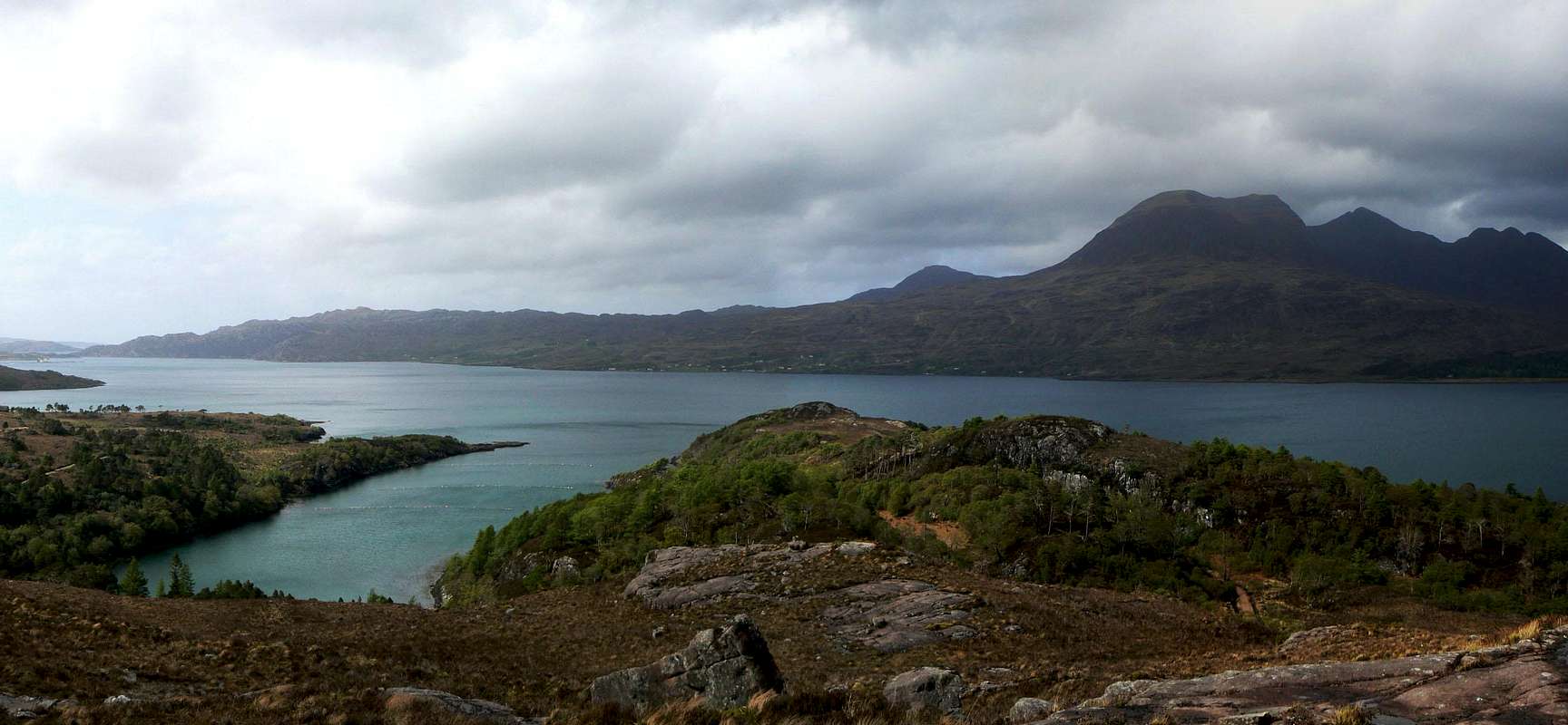
Upper Loch Torridon & Beinn Alligin from the Shieldaig road. (Photo by: Boydie)
There is also the option to wild camp. Wild camping is totally legal in Scotland, again due to the Land Reform (Scotland) Act 2003 that was mentioned earlier. Here are some of the basic rules that should be adopted when wild camping;
- The larger the group, the harder it is to keep impacts to a minimum. Keep groups small.
- Camp as unobtrusively as possible.
- Remember that noise travels from tents disturbing wildlife as well as humans.
- Enjoy the freedom of wild camping without leaving a trace of your passage. Protect our country's outstanding scenery and wildlife as well as the wilderness experience.
- Camping on the same spot harms vegetation. Aim to move frequently and do not stay for any longer than 3 nights in the same place.
- Lighting fires poses a high fire risk on peaty soils and close to tinder dry grass. A high risk of fire can exist at any time of year, and not just in times of drought.
- Watercourses and loch sides are important sites for birds and animals. Take extra care when camping near burns and lochs, and try to avoid camping immediately beside them.
- Always find a spot at least 30 metres from fresh/running water when going to the toilet.
- Bury excrement in a small hole (not under boulders). A trowel or ice axe can be used to lift a flap of turf.
- Remove all litter (even other peoples!) Think ahead and only carry in what you are prepared to carry out.
The Mountaineering Council of Scotland provides an invaluable leaflet providing a full breakdown of the dos and don'ts of wild camping in Scotland. Wild Camping, A guide to good practice.
When To Climb
Summer
Beinn Alligin is a popular destination in the summer months, especially at the weekends, when most of the winter snow has subsided. Generally between the months of May to October there will be little snow found, although any still found will mainly be in the gullies or on northern facing sides of the peak.
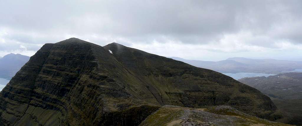
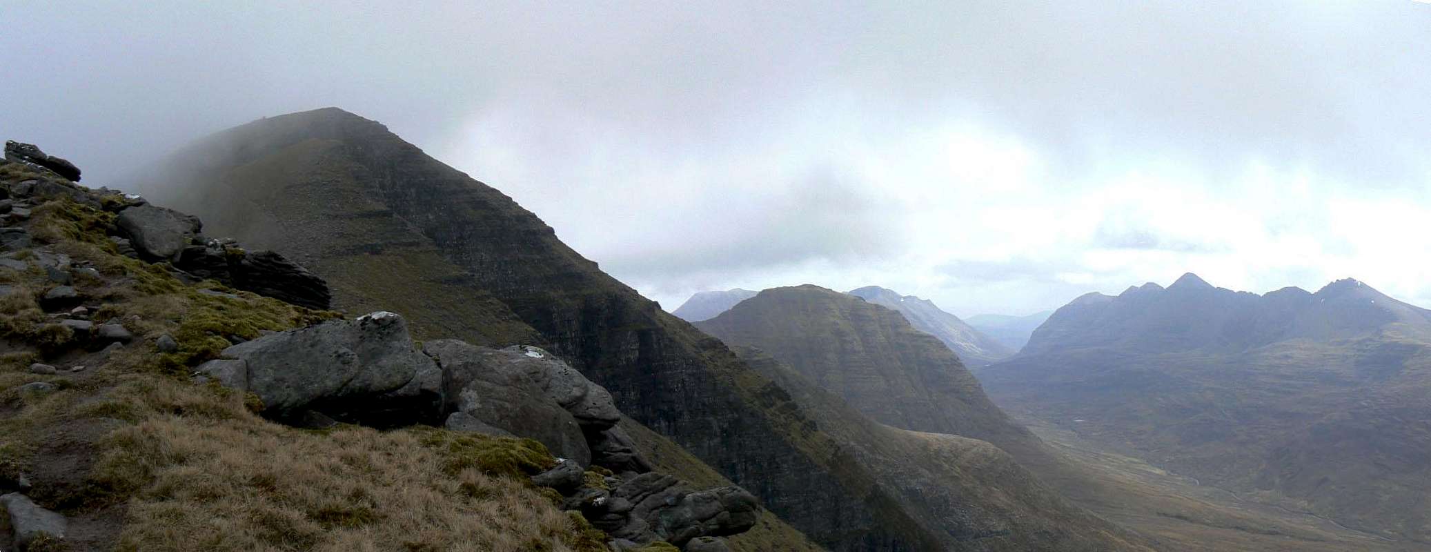
Tom na Gruagaich & Meall an Laoigh on the descent from Sgurr Mhor. (Photo by Boydie)
Winter
In winter, climbing Beinn Alligin is a serious undertaking and should not be attempted by the inexperienced. Whatever you do, do not underestimate this mountain as it has many dangers and is prone to avalanche at this time of year. The amount of daylight hours during the winter months in the area is also limited and you should therefore ensure you have allowed enough time to be completed before the sun sets.
YouTube - The Munro Show
The following video is from a vintage television programme that was shown on Scottish Television in the late 80's, called the Munro Show. This episode, obviously, is on Beinn Alligin. The video states that Tom na Gruagaich is a Munro top, however this has been elevated to full Munro since the show was made. Enjoy!
Mountain/Weather Conditions
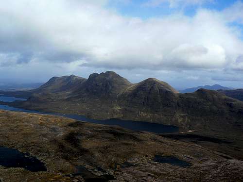
Sgurr Mhor and the peaks of Torridon. (Photo by: Boydie)
The weather conditions in the Torridon can alter rapidly due to its location close to the western coast of Scotland and you should ensure you are fully prepared for all weather eventualities. The following websites will provide invaluable information on the expected conditions for your planned trip. The first link is also posted in the Torridon visitors centre on a daily basis.
West Highlands Forecast
Torridon Mountain forecast
Avalanche forecast
General weather forecast
Books & Maps
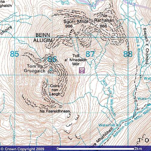
Image reproduced with permission of Ordnance Survey and Ordnance Survey of Northern Ireland.
Books
The North-West Highlands by Dave Broadhead, Alec Keith & Ted Maden
The Munros (SMC Hillwalkers guide) edited by Donald Bennet & Rab Anderson
Scottish Hill and Mountain Names by Peter Drummond
The Munros by Cameron McNeish
The Scottish Peaks by W. A. Poucher
The Munros Vol 2 - Northern Highlands and the Cairngorms by Steve Kew
Torridon by Peter Barton
Maps
Harvey Superwalker Map: Torridon
OS Explorer Map sheet: 433 Torridon - Beinn Eighe & Liathach
OS Landranger Map sheet: 24 Raasay & Applecross
External Links
Visit Scotland
Discover Scotland
Undiscovered Scotland
Walk the Highlands
The Scottish Mountaineering Club
Munro Magic
Mountain Rescue Committee of Scotland
Buachaille.com
Visit Torridon
Visit Wester Ross
Torridon & Sheildaig (A really comprehensive guide to the area)
Beinn Eighe Nature Reserve
The National Trust for Scotland