
|
|
Mountain/Rock |
|---|---|
|
|
35.03830°N / 108.3533°W |
|
|
Hiking, Scrambling |
|
|
Spring, Summer, Fall, Winter |
|
|
7515 ft / 2291 m |
|
|
Overview
El Morro is more of a hill or bluff than it is a true mountain, but it is one of the most interesting summits in New Mexico. Its name means "The Castle" in Spanish. Despite its small nature, it is my favorite summit that I have climbed in that state. Not only is the peak scenic with towers cliffs and big pine trees growing out of solid rock, but it has much historical significance as well. There are ancient Anasazi ruins and petroglyphs as well as many signatures of explorers dating back to at least 1604 (16 years before the pilgrims landed at Plymouth Rock!).
The rock itself is quite colorful and the vegetation and pools of water make an interesting site and its stand alone nature has been a beacon to travelers for hundreds or thousands of years. The views from the summit stretch for many miles.
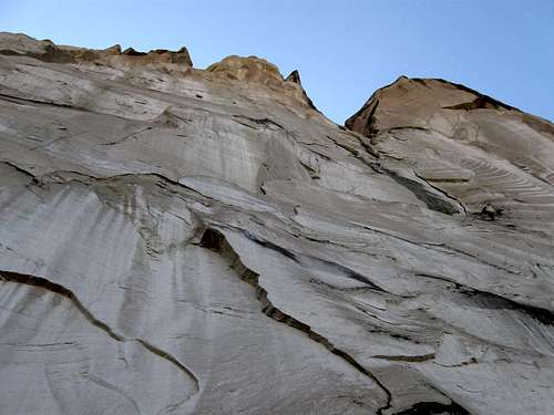 Looking straight up the face of El Morro.
Getting There
El Morro is located on State Highway 53 about 43 miles south and west from Grants or take Highway 602 south from Gallup before turning east on State Highway 53 and heading to El Morro.
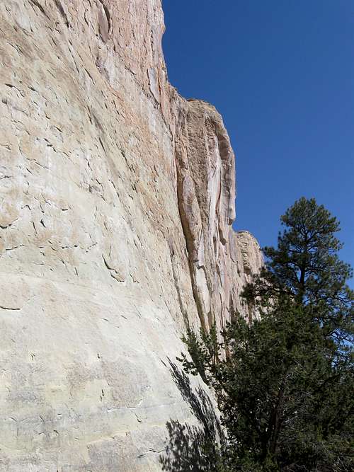 These are the lower cliffs of El Morro not far from the trailhead.
Route Overview
This summit isn’t that big, so the loop route over the top is only 2.3 miles long. You can still spend much time here viewing the cliffs, petroglyphs, ruins and enjoying the views from the summit. The NPS claims the trail is strenuous, but there is only very minor scrambling and anyone that can walk should be able to handle it.
 The trail over the summit of El Morro is marked with rock cairns.
 Red Tape
There is a small entrance fee to enter the national monument. Make sure to borrow the interpretive map that explains the signatures and other features of the peak.
Obviously, don't add any modern signatures to the rocks at El Morro.
Although the park is open until 5 PM, you aren't allowed to start the hike after 3 PM.
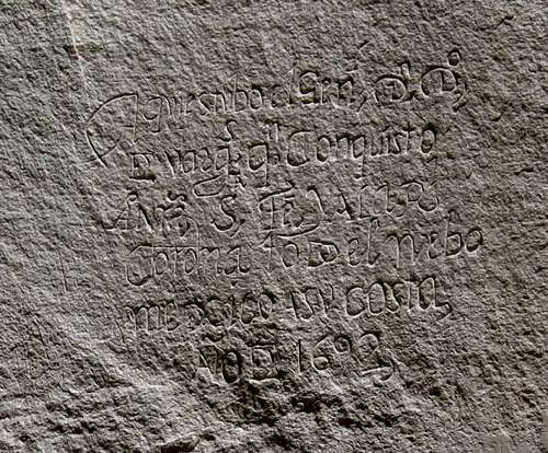 El Morro has been a landmark for hundreds or thousands of years. There are many ancient petroglyphs and explorer's signatures hundreds of years old. This one is from 1692.
Camping
There is a nice campground near the trailhead. See below for information:
El Morro Campground
When to Climb
The summit can be climbed year round, but sometimes in winter or early spring some sections can be really icy. Something like Yaktrax or Stablicers will come in handy. Summers are warm, but not extremely hot since the altitude is fairly high. Mid July through mid September is monsoon season and heavy thunderstorms are possible.
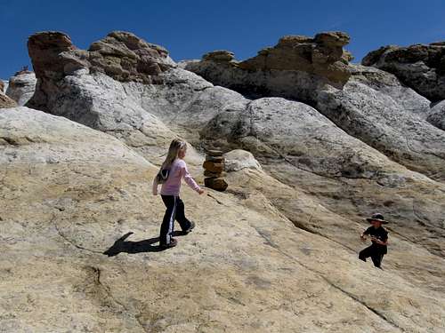
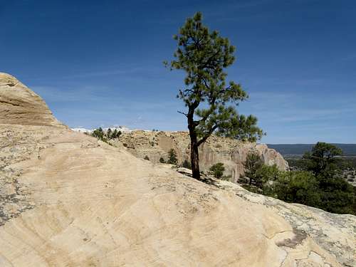 Trees grow out of the solid rock on El Morro. This is a sunny day in March.
Mountain Conditions
See below for the contacts for the NPS for current conditions:
El Morro National Monument Contacts
Click Here For El Morro Weather Forecast
Weather and climate data for El Morro Visitor Center at 7220 feet elevation is below. *National Weather Service Data 1938-2008.
| MONTH | AVE HIGH | AVE LOW | REC HIGH | REC LOW | AVE PRECIP (in) |
| JAN | 43 | 13 | 69 | -38 | 1.03 |
| FEB | 47 | 17 | 72 | -21 | 0.87 |
| MAR | 53 | 23 | 77 | -15 | 1.12 |
| APR | 63 | 28 | 81 | 3 | 0.73 |
| MAY | 73 | 35 | 93 | 12 | 0.59 |
| JUN | 83 | 43 | 104 | 23 | 0.55 |
| JUL | 85 | 51 | 98 | 34 | 1.95 |
| AUG | 82 | 50 | 97 | 33 | 2.74 |
| SEP | 77 | 43 | 94 | 21 | 1.36<TD |
| OCT | 67 | 32 | 87 | 8 | 1.13 |
| NOV | 53 | 21 | 78 | -23 | 0.77 |
| DEC | 45 | 14 | 69 | -32 | 0.99 |
Stu Brandel - Oct 22, 2021 2:48 pm - Voted 10/10
Note on Summit Trail Closing at 3 PMBecause the monument closes at 5 PM, the staff closes the summit trail at 3 PM. I got there at 3:05 and was told that they had just closed the summit loop trail. I had to plead my case that I was a fast hiker and promise to back before 4:45 (no problem for most SPers, even when spending time reading the inscriptions). This really is a special and glorious place - just get there earlier than 3 PM and avoid hassles.
Scott - Oct 22, 2021 6:07 pm - Hasn't voted
Re: Note on Summit Trail Closing at 3 PMGood info. Let me add this to the page under the Red Tape section.