
-
 23392 Hits
-
 85.87% Score
-
 21 Votes
|
|
Mountain/Rock |
|---|---|
|
|
47.46326°N / 121.34674°W |
|
|
King/Kittitas |
|
|
Hiking, Scrambling |
|
|
Summer, Fall |
|
|
5745 ft / 1751 m |
|
|
Overview

Alaska from PCT

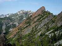
Chimney Rock Group in distance
Getting There
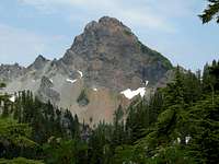
Red from PCT

Kendall Katwalk

Gravel Lake
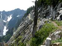
Kendall Katwalk
Hike the PCT 5 miles north to the Kendall Katwalk. Or alternatively, find the old Commonwealth Basin Trail shortly above the trailhead. Hike the PCT only about 100 yards to the intersection with an overgrown road. Head left on the road to the road end, finding an old, eroded trail heading up on the right. Follow this trail up about 700 vertical feet to the entrance to Commonwealth Basin. Hike the fine trail here for about 1/2 mile. Look on the right side for a junction with the PCT. Taking the Commonwealth Basin approach cuts 1 mile each way out of this trip, and also saves about 400 feet in elevation gain. As you climb up the PCT, you will have great views of the Commonwealth Basin peaks such as Guye Peak, Snoqualmie Mountain, Lundin Peak, and Red Mountain.
Continue past the Kendall Katwalk another mile, passing Gravel Lake on your left, and Ridge Lake on your right. Once past those lakes, dangerous snowfields can linger here into August, depending on the year. BRING AN ICE AX. Look 800 feet down to huge Alaska Lake and across Gold Creek Valley to Hibox Mountain and Alta Mountain. Continue another mile to the southeast ridge of Alaska Mountain, which is the brushy, wooded hill to your left. Climb easily to the summit.
Wonderful views of surrounding peaks will greet you. This is an easy peak and a wonderful vantage point for loftier summits.
Trip Stats: 16 miles roundtrip (14 miles roundtrip by Commonwealth Basin). About 3000 feet elevation gain with ups and downs. Mainly Class 1 except on snowfields and the final 300 feet to the summit, which is Class 2.
Red Tape

Alaska Lake

Crossing Snowfields
Camping
Mount Thompson

Gold Creek Valley
External Links

Alta Mountain

TOPO! Software Image.
District Ranger
North Bend Ranger Station
North Bend, WA 98045
(425) 888-1421
Snow conditions are available from the Summit at Snoqualmie Ski Areas (of which Alpental is one) at the following website:
Summit at Snoqualmie Snow Conditions
Also, webcams are available from the Washington State Department of Transportation at: Snoqualmie Pass Web Cam