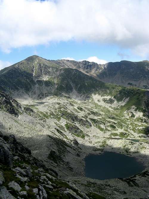
Parângul Mare (left) and Gemănarea (right) shot in 2010 by LukZem
NE face of Great Parângul
Cliffs of Gemănarea
Approaching from N
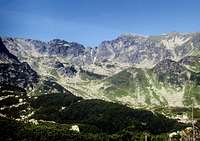
Parângul Mare (mare = great) is great indeed - it is 2519m high (or perhaps 2518m, according to some new measurements) and has as much as 2103m of prominence, which makes it the most prominent peak in Romania and the second most prominent peak in all of the Carpathians. The peak was and is still sometimes called Mândră (proud), but today this is actually the name of its secondary summit, just south of Parângul Mare. The western neighbour of Parângul Mare is the second highest peak of the Parâng Mountains, Gemănarea at 2426m.
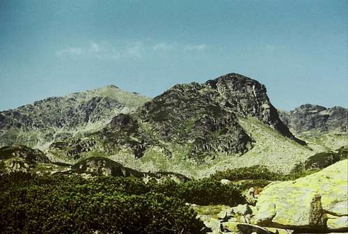
Parângul Mare (left), Pontul Roşu and Gemănarea (right) shot in 1979
Whereas most of the vast mountainous area comprising the Parâng mountain group, between the Retezat in the east and the Făgăraş in the west – is of crystalline schists, gneisses and other metamorphic rocks, and looks a bit like a rolling upland, elevated high and dissected by a handful of deep valleys, the central part of the Parâng proper is of granite and other igneous rocks, which results in the summit of Parângul Mare being so high.
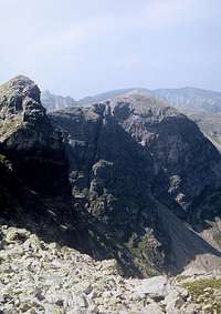
Parângul Mare shot in 2010
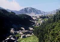
Main ridge between highest peaks
Gemănarea shot in 2010
In the two great postglacial corries over which tower the peaks of Gemănarea, Parângul Mare and its eastern neighbour Gruiu (2345m) rises the Jieţ River. The river, or rather brook, rushes north for several kilometers, takes a right angle turn to the west, cuts a narrow, nearly six kilometres long gorge just before reaching the town of Petroşani, where – as if unwilling to part with its home mountains – it merges with the Jiu de Est and soon takes another right angle turn to finally flow into the Jiu River and continue south, thus forming the west border of the Parâng Mountains.,
Wall of Jieț Gorge
N face of Gruiu
Jieţ Valley
The springs of the Jieţ River and the Pleistocene glaciers took turns to bite deep into the north side of the granite bulk of Parângul Mare. As a result, it has the classic alpine, or rather Tatra-like looks and cradles three tarns, including the biggest and deepest lake in these mountains, Lacul Roşiile aka Tăul fără Fund, meaning Bottomless Tarn (in fact 17.6 m deep).
Mândra Lake in 2010
Mândra and Roşiile lakes
Roşiile Lake in 2010
Northwest of Parângul Mare, beyond the ridge of Pontul Roşu (Red Spur) that extends northeasterly from the main summit splitting Roşiile cirque in half, at the foot of Gemănarea, sits the other half of the cirque. Here, some of the igneous rocks turn reddish in colour while weathering. The whole cirque contains the headwaters of the Jieţ River.
NW half of Roşiile cirque
Headwall of Roşiile cirque
Bygone shepherd hut
The southern and western slopes and side ridges of the Parâng Mountains, including Parângul Mare, are long, smooth and monotonous, the sub-alpine mountain pine – unlike on the other, rocky side of the main ridge – has been virtually cut down and given way to pastureland.
Graben on main ridge
Gentle W side
On SW trail
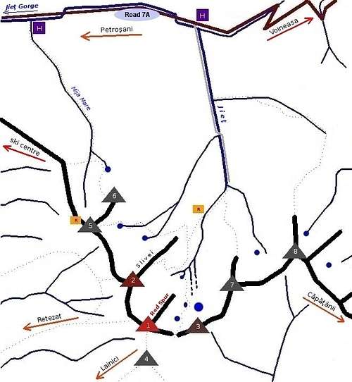
Hiking Routes & Maps
1 Parângul Mare (2519m), 2 Gemănarea (2426), 3 Gruiul (2345), 4 Mândra (2330), 5 Cârja (2406), 6 Mija (2372), 7 Ieşul (2375), 8 Coasta lui Rus (2301) R=refugeH=hut
The routes listed below are marked, but in these mountains you don't have to stick to marked routes so hiking and scrambling possibilities are endless.
A set of old maps online - from sketch to large scale representations of the most interesting sections is availablehere. An Austrian map from the 1910s, with Mândră in place of Parângul Mare, can be seen here. For the new maps please see the parent page.
From the North: from Groapa Seaca Hut (1,208m) on Road 7A (!not Groapa Seaca Pass, which is farther east): a few kilometers up a gravel road, then up a scenic glacial valley and past pretty tarns at the valley head: 5.5 hours, marked with red circles. (A similar option is a hike up the Mija valley but it doesn’t lead directly to Parangul Mare.)
From Petroşani: not the most original route, which leads from the upper end of the chair lift/car park at Hotel Rusu (1168m): 5.5 hours, red stripes. (This is actually part of the traverse of the main ridge of the South Carpathians.)
From/To the railway in the West: A fair deal for a descent rather than an ascent, especially if going to continue hiking in the Retezat or Vâlcan mountains – down one of either ridge lining the valley of the Cutreasa Stream, which has its sources on the west slopes of Gemănarea, towards the towns of Iscroni and Livezeni, a south suburb of Petroşani: 7-8 hours, waymarked with red crosses or unmarked
From/To the railway in the South-West: The train stop at Lainici (500m), south of Livezeni, 9 hours up, red circles
Other Information & Closing Note
For other information (how to get there, red tape, camping, weather forecast, external links, etc.) please see the parent page.
Emergency bivouac :) by E79
Jieţ River gorge
My tent from 1960s
After storm
Groapa Seaca Hut
I have set foot on the top of the Parângul Mare a couple of times, I actually returned to the mountain because during my first visit the previous year, while I was doing the traverse of the South Carpathians, the clouds didn't let me see much of the north side of the main ridge of the Parâng Mountains except for the hazy silhouettes of chamois in the couloirs as well as vague outlines of the tarns down below. Since all this happened well before the arrival of the digital era, this page was originally decorated only with scanned transparencies. ButLukZem, who visited the Parâng in August 2010 and brought plenty of photographs for the then created area page - can confirm what I discovered while gleaning material for this page on the Internet: Little has changed in these mountains since I went trekking there towards the end of the 1970s!
A few days before reaching Parângul Mare, Căpăţânii Mts, August 1978
Parents refers to a larger category under which an object falls. For example, theAconcagua mountain page has the 'Aconcagua Group' and the 'Seven Summits' asparents and is a parent itself to many routes, photos, and Trip Reports.


 A few days before reaching Parângul Mare, Căpăţânii Mts, August 1978